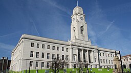
Metropolitan Borough of Barnsley
| Barnsley | |
| Storstadsdistrikt | |
| Land | |
|---|---|
| Riksdel | England |
| Region | Yorkshire och Humber |
| Ceremoniellt grevskap | South Yorkshire |
| Koordinater | 53°32′N 1°30′V / 53.53°N 1.5°V |
| Huvudort | Barnsley |
| Area | 329 km²[1] |
| Folkmängd | 246 482 (2022)[2] |
| Befolkningstäthet | 749 invånare/km² |
| Tidszon | UTC (UTC+0) |
| - sommartid | BST (UTC+1) |
| ISO 3166-2-kod | GB-BNS- |
| GSS-kod | E08000016 |
| Geonames | 3333122 |
Contains Ordnance Survey data © Crown copyright and database right, CC BY-SA 3.0 Läge i grevskapet South Yorkshire | |
Metropolitan Borough of Barnsley är ett storstadsdistrikt (kommun) i South Yorkshire i England, Storbritannien. Distriktet har 246 482 invånare (2022)[2].
Större orter är: Barnsley, Cudworth, Darton, Hoyland, Royston och Wombwell.
Större delen av distriktet (med cirka 90 procent av befolkningen) är inte indelat i civil parishes. Resten är indelat i 17 civil parishes: Billingley, Cawthorne, Dunford, Great Houghton, Gunthwaite and Ingbirchworth, High Hoyland, Hunshelf, Langsett, Little Houghton, Oxspring, Penistone, Shafton, Silkstone, Stainborough, Tankersley, Thurgoland och Wortley.
Källor
- ^ ”Estimates of the population for the UK, England, Wales, Scotland, and Northern Ireland (Mid-2022)” (på engelska) (xls). Landyta, avrundad till hela km². Office for National Statistics. 26 mars 2024. https://www.ons.gov.uk/peoplepopulationandcommunity/populationandmigration/populationestimates/datasets/populationestimatesforukenglandandwalesscotlandandnorthernireland. Läst 25 juni 2024.
- ^ [a b] ”Estimates of the population for the UK, England, Wales, Scotland, and Northern Ireland (Mid-2022)” (på engelska) (xls). Office for National Statistics. 26 mars 2024. https://www.ons.gov.uk/peoplepopulationandcommunity/populationandmigration/populationestimates/datasets/populationestimatesforukenglandandwalesscotlandandnorthernireland. Läst 25 juni 2024.
Externa länkar
 Wikimedia Commons har media som rör Barnsley.
| |||||
Media som används på denna webbplats
Contains Ordnance Survey data © Crown copyright and database right, CC BY-SA 3.0
Map of South Yorkshire, UK with Barnsley highlighted.
Equirectangular map projection on WGS 84 datum, with N/S stretched 165%


