Meridianplan
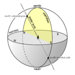
Meridianplanet avser vanligen det tänkta plan som innehåller såväl den geodetiska meridianen som den astronomiska meridianen på en planet. Det är vinkelrätt mot horisontalplanet och skärningslinjen dem emellan kallas "middagslinjen"[1][2] Middagslinjen är tangenten till jordytan i meridianplanet och definierar den sanna nord-syd-riktningen för tangeringspunkten. Meridianplanet för en punkt på jorden innehåller, förutom punkten själv, dess zenit, nadir, nordpunkt och sydpunkt, jordaxeln, båda geodetiska polerna och de båda himmelspolerna.
En punkt på jordytan ligger även i ett (geo)magnetiskt meridianplan, vilket avser det vertikala plan som en fritt hängande, perfekt balanserad, magnet inrättar sig efter. Vinkeln mellan de magnetiska och geodetiska meridanplanen i punkten kallas magnetisk deklination eller "kompassens missvisning". [3][4][5] Den fritt hängande magnetens vinkel i förhållande till horisontalplanet kallas inklination.[6]
Meridianplanen följer jorden i dess rotation kring sin egen axel.
Astronomisk meridian.

Två geodetiska meridianplan skär varandra i jordaxeln.

Det geomagnetiska fältets horisontella riktningskomponent vid jordytan. En punkts magnetiska meridianplan spänns upp av den lokala horisontella komponenten och lodlinjen.
Referenser
- ^ Middagslinje i Nationalencyklopedin.
- ^ Middagslinjen i Store norske leksikon.
- ^ How Magnets Work - Earth's Magnetic Fields.
- ^ Numerical Physics Volume II, sid 3.57. ISBN 9788187224778.
- ^ V. K Mehta & Rohit Mehta, 2013, S. Chand s Principle Of Physics -XII, 7 uppl., sid. 566. ISBN 9788121917698.
- ^ Jacob Heussi, 1861, Lehrbuch der Geodäsie, Brockhaus, §100 på sid. 138.
Media som används på denna webbplats

figure 104a of American Practical Navigator (2002 NIMA pdf edition)

Författare/Upphovsman: Tfr000 (talk) 16:56, 18 June 2012 (UTC), Licens: CC BY-SA 3.0
Diagram of the local meridian on the celestial sphere, depicting the north and south celestial poles, the zenith, the nadir, and the north, south, east, and west points on the horizon.

Författare/Upphovsman: User:Sch, Licens: CC BY-SA 4.0
The diagram shows the magnetic meridians of the Earth's magnetic field. It is centered on the point at latitude 30° and longitude 0°.
The magnetic meridians (not to be confused with magnetic field lines) follow the directions shown by a magnetic compass, that is, they follow the direction of the horizontal component of the field lines in the vicinity of the Earth's surface and thus show the shape of the field. The angle between the magnetic meridians (red) and the geographic meridians (blue, running precisely north-south) is the magnetic declination. The diagram demonstrates the irregularities of the Earth's magnetic field and the fact that in general compasses point neither towards the geographic north pole nor towards the magnetic north pole.
The magnetic field was computed using the coefficients of the International Geomagnetic Reference Field for the epoch 2010.