McKinney
| Den här artikeln behöver källhänvisningar för att kunna verifieras. (2019-12) Åtgärda genom att lägga till pålitliga källor (gärna som fotnoter). Uppgifter utan källhänvisning kan ifrågasättas och tas bort utan att det behöver diskuteras på diskussionssidan. |
| McKinney | |
| Land | |
|---|---|
| Delstat | Texas |
| Läge | 33°11′50″N 96°38′23″V / 33.19722°N 96.63972°V |
| Yta | |
| - total: | 151,5 km² |
| - varav land: | 150,3 km² |
| - varav vatten: | 1,2 km² |
| Folkmängd | 127 671 (2010) |
| Geonames | 4710178 |
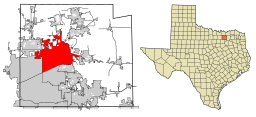
McKinneys läge i Collin County och Collin Countys läge i Texas. | |
McKinney är en stad i den amerikanska delstaten Texas med en yta av 151,5 km² och en folkmängd som uppgår till 127 671 invånare (2010). McKinney är administrativ huvudort i Collin County. Både staden och countyt har fått sina namn efter politikern Collin McKinney som var med om att underteckna Republiken Texas självständighetsförklaring.
Externa länkar
 Wikimedia Commons har media som rör McKinney.
- Officiell webbplats
|
Media som används på denna webbplats
Författare/Upphovsman: Tkgd2007, Licens: CC BY-SA 3.0
A new incarnation of Image:Question_book-3.svg, which was uploaded by user AzaToth. This file is available on the English version of Wikipedia under the filename en:Image:Question book-new.svg
This map shows the incorporated areas in Collin County, Texas. McKinney is highlighted in red. I created it in Inkscape using data from the Collin County GIS Website ([1]) and the North Central Texas Council of Governments Website ([2]).


