Maseepho Community

Maseepho Community
Gemenskap
LandLesotho Lesotho
DistriktQacha's Nek
Höjdläge2 251 m ö.h.
Koordinater30°00′46″S 28°32′47″Ö / 30.0128°S 28.5465°Ö / -30.0128; 28.5465
TidszonCAT (UTC+2)
Geonames7576622
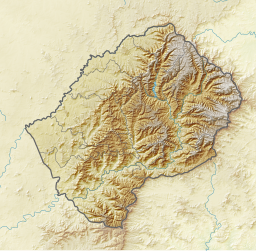
Läge i Lesotho
Läge i Lesotho
Läge i Lesotho

Maseepho Community är en gemenskap i Lesotho.[1] Den ligger i distriktet Qacha's Nek, i den centrala delen av landet, 130 km sydost om huvudstaden Maseru.

Kustklimat råder i trakten.[2] Årsmedeltemperaturen i trakten är 15 °C. Den varmaste månaden är januari, då medeltemperaturen är 22 °C, och den kallaste är juni, med 6 °C.[3] Genomsnittlig årsnederbörd är 1 072 millimeter. Den regnigaste månaden är december, med i genomsnitt 195 mm nederbörd, och den torraste är juli, med 11 mm nederbörd.[4]

Maseepho Community
Klimatdiagram (förklaring)
JFMAMJJASOND
 
 
179
 
31
12
 
 
172
 
29
12
 
 
151
 
24
11
 
 
52
 
21
8
 
 
12
 
17
5
 
 
18
 
11
1
 
 
11
 
13
1
 
 
29
 
17
4
 
 
57
 
25
7
 
 
88
 
29
8
 
 
108
 
32
10
 
 
195
 
31
12
Genomsnittlig temperatur i °C (max. och min.)
Nederbörd i mm. Årsnederbörd: 1 072 mm.
Källa: [3]

Källor

  1. ^ Maseepho Community hos Geonames.org (cc-by); post uppdaterad 2010-10-26; databasdump nerladdad 2016-10-20
  2. ^ Peel, M C; Finlayson, B L; McMahon, T A (2007). ”Updated world map of the Köppen-Geiger climate classification”. Hydrology and Earth System Sciences 11: sid. 1633-1644. doi:10.5194/hess-11-1633-2007. http://www.hydrol-earth-syst-sci.net/11/1633/2007/hess-11-1633-2007.html. Läst 30 januari 2016. 
  3. ^ [a b] ”NASA Earth Observations Data Set Index”. NASA. Arkiverad från originalet den 11 maj 2020. https://web.archive.org/web/20200511075542/https://neo.sci.gsfc.nasa.gov/dataset_index.php. Läst 30 januari 2016. 
  4. ^ ”NASA Earth Observations: Rainfall (1 month - TRMM)”. NASA/Tropical Rainfall Monitoring Mission. Arkiverad från originalet den 10 maj 2020. https://web.archive.org/web/20200510015436/https://neo.sci.gsfc.nasa.gov/view.php?datasetId=TRMM_3B43M. Läst 30 januari 2016. 

Media som används på denna webbplats

Robot icon.svg
Robot icon
Lesotho relief location map.svg
Författare/Upphovsman: , Licens: CC BY-SA 3.0
Relief location map of Lesotho

Equirectangular projection. Geographic limits of the map:

  • N: 28.33° S
  • S: 30.89° S
  • W: 26.74° E
  • E: 29.62° E
Red pog.svg
Shiny red button/marker widget. Used to mark the location of something such as a tourist attraction.