Marsskalv

Marsskalv[1] eller marsbävning[2] är seismisk aktivitet som sker på planeten Mars. Skalven påminner om jordbävningar som sker på jorden. Upptäckten av marsskalv skedde huvudsakligen av uppdraget Insight där en rymdsond utrustad med en seismograf landade på Elysium Planitia på Mars i november 2018.[3]
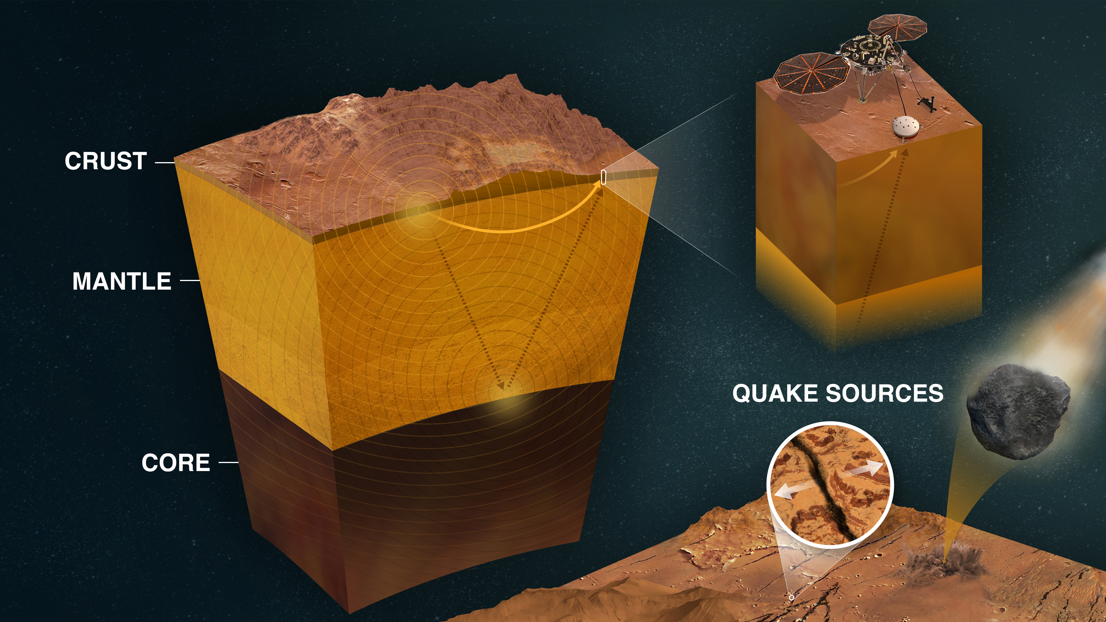
Skalven kan delas upp i två distinkta grupper: en grupp med seismiska händelser av liten magnitud och med hög frekvens som sprids genom Mars skorpa och en annan grupp med lågfrekventa skalv på en magnitud av 3-4 Mw som sker under planetens skorpa och sprids genom manteln.[3] Eftersom Mars - till skillnad från jorden - saknar tektoniska plattor kan inte skalven förklaras av rörelser i dessa. Troligen uppstår skalven av stora områden av stenmaterial som rör sig upp mot ytan från varma regioner djupt inom Mars och därmed skapar seismisk aktivitet.[4]
Det kraftigaste skalvet som uppmättes skedde den 4 maj 2022, då Insight registrerade ett skalv av magnituden 4,7, vilket var fem gånger starkare än det tidigare rekordet 4,2. Skalvet utmärkte sig även för att hålla på i sex timmar, jämfört med de flesta andra skalv som avtar inom en timme. Skalvet på 4,7 var tillräckligt starkt för att forskare först trodde att det hade orsakats av ett asteroidnedslag, något man dock inte fann bevis för och därför konstaterade att händelsen troligen orsakades av seismisk aktivitet.[5]
Se även
Referenser
- ^ S. V. T. Nyheter (24 april 2019). ”Sond kände av ett första Marsskalv – forskare: ”Vi är väldigt övertygade””. SVT Nyheter. https://www.svt.se/nyheter/vetenskap/sond-kande-av-ett-forsta-marsskalv-1. Läst 7 januari 2025.
- ^ Victor Blomdahl (28 oktober 2022). ””Marsbävning” förbryllade – nu är mysteriet löst”. Göteborgs-Posten. https://www.gp.se/nyheter/varlden/marsbavning-orsakades-av-meteorit-.a347b02e-a9f1-43a8-90e8-6aab832da5d6. Läst 7 januari 2025.
- ^ [a b] Giardini, D.; Lognonné, P.; Banerdt, W. B.; Pike, W. T.; Christensen, U.; Ceylan, S. (2020-03). ”The seismicity of Mars” (på engelska). Nature Geoscience 13 (3): sid. 205–212. doi:. ISSN 1752-0908. https://www.nature.com/articles/s41561-020-0539-8. Läst 7 januari 2025.
- ^ ”New study: Earth has earthquakes; Mars has ‘marsquakes’” (på engelska). science.vt.edu. https://www.science.vt.edu/research/around-the-college/marsquakes.html. Läst 7 januari 2025.
- ^ Sharmila Kuthunur published (17 oktober 2023). ”Mars was shaken by its strongest marsquake ever in 2022. Now we know what caused it” (på engelska). Space.com. https://www.space.com/mars-marsquake-strongest-ever-2022-cause. Läst 7 januari 2025.
| ||||||||||||||||||||||||||||||||||||||||||||||||||||||||
Media som används på denna webbplats

NASA's Hubble Space Telescope took the picture of Mars on June 26, 2001, when Mars was approximately 68 million kilometers (43 million miles) from Earth — the closest Mars has ever been to Earth since 1988. Hubble can see details as small as 16 kilometers (10 miles) across. The colors have been carefully balanced to give a realistic view of Mars' hues as they might appear through a telescope. Especially striking is the large amount of seasonal dust storm activity seen in this image. One large storm system is churning high above the northern polar cap (top of image), and a smaller dust storm cloud can be seen nearby. Another large dust storm is spilling out of the giant Hellas impact basin in the Southern Hemisphere (lower right).
PIA25282: How InSight Studies Mars' Inner Layers
https://photojournal.jpl.nasa.gov/catalog/PIA25282
click here for larger version of figure A for PIA25282 Figure A
click here for larger version of figure B for PIA25282 Figure B
click here for larger version of figure C for PIA25282 Figure C Click on images for larger versions
NASA's InSight Mars lander uses a seismometer to study the inner layers of Mars. Seismic signals from quakes change as they pass through different kinds of materials; seismologists can "read" the squiggles of a seismogram to study the properties of the planet's crust, mantle, and core.
This infographic shows those layers, and how InSight uses quakes to study them. It also shows a close-up of InSight and the major sources of marsquakes. Most quakes are created by heat and pressure inside the planet, which cause rock to fracture; another source is meteors striking the surface.
Figure A is a horizontal version of the infographic without a title but with some annotations added.
Figure B is a horizontal version of the infographic with a title and detailed annotations.
Figure C is a vertical version of the infographic with a title and detailed annotations.
JPL manages InSight for NASA's Science Mission Directorate. InSight is part of NASA's Discovery Program, managed by the agency's Marshall Space Flight Center in Huntsville, Alabama. Lockheed Martin Space in Denver built the InSight spacecraft, including its cruise stage and lander, and supports spacecraft operations for the mission.
A number of European partners, including France's Centre National d'Études Spatiales (CNES) and the German Aerospace Center (DLR), are supporting the InSight mission. CNES provided the Seismic Experiment for Interior Structure (SEIS) instrument to NASA, with the principal investigator at IPGP (Institut de Physique du Globe de Paris). Significant contributions for SEIS came from IPGP; the Max Planck Institute for Solar System Research (MPS) in Germany; the Swiss Federal Institute of Technology (ETH Zurich) in Switzerland; Imperial College London and Oxford University in the United Kingdom; and JPL. DLR provided the Heat Flow and Physical Properties Package (HP3) instrument, with significant contributions from the Space Research Center (CBK) of the Polish Academy of Sciences and Astronika in Poland. Spain's Centro de Astrobiología (CAB) supplied the temperature and wind sensors.
For more information about the mission, go to https://mars.nasa.gov/insight.