Marie Byrds land
Marie Byrds Land (engelska: Marie Byrd Land) är ett landområde i västra Antarktis. Här ligger Bentley Subglaciärgraven som med ett djup på ca 2 555 meter under havsytan är jordytans djupaste punkt och tillhör världens yttersta platser.
Geografi
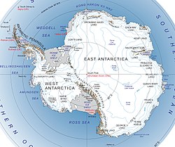
Marie Byrds Land ligger i Västantarktis mellan Ellsworth Land och Edward VII land. Området ligger direkt vid Amundsenhavet mellan George VI-shelfis och Sulzberger shelfis. Kusten är cirka 2 000 km lång och området sträcker sig mellan cirka 103° 24' V till 150° 50' V.
Området är kuperad med flera bergskedjor däribland Executive Committee Range nära kusten, den högsta toppen här är Mount Sidley med 4 285 m ö.h. Det finns även en rad glaciärer, de största är Haynes glaciären, Smith glaciären och Kohler glaciären. Området betraktas som den region på jorden som har mest vulkaner. Här finns 23 stora vulkaner där de högsta är Mount Takahe (3 460 m ö.h.) och Mount Murphy (2 705 m ö.h.).[1][2]
Marie Byrd Land omfattar
- delar av Walgreen Coast (103° 24' V till 114° 12' V)
- Bakutis Coast, mellan 114° 12' V till 127° 35' V
- Hobbs Coast, mellan 127° 35' V till 136° 50' V
- Rupert Coast, mellan 136° 50' V till 146° 31' V
- delar av Saunders Coast, (146° V till 155° V)
Det finns en övergiven forskningsstation i området, den ryska Russkaya Station (Русская, 74° 46' S / 136° 52' V) som ligger i Rupert Coast.
Området är det enda landområde på Antarktis som ingen nation gjort territoriella landanspråk på, dock hade USA planer på att göra anspråk på området.
Historia
Marie Byrds Lands kust upptäcktes i december 1929 av amerikanske Richard Evelyn Byrd under dennes första antarktiska flygexpedition åren 1928–1930, området namngavs då efter Byrds hustru Marie.
Området utforskades under Byrds andra flygexpedition åren 1933–1935 och United States Antarctic Programs expedition åren 1939–1941.
Walgreen Coast upptäcktes i februari 1940 och namngavs efter svenskättade Charles Rudolph Walgreen, en stor bidragsgivare till Byrds andra expedition.
1947 fastställdes det nuvarande namnet av amerikanska "Advisory Committee on Antarctic Names" (US-ACAN, en enhet inom United States Geological Survey).
Den sovjetiska forskningsstationen Russkaja invigdes den 9 mars 1980 och var bemannad till 1990.
Referenser
- ^ Geographic Names Information System (GNIS) (läst 30 november 2010)
- ^ Composite Gazetteer of Antarctica (SCAR) (läst 30 november 2010)
Externa länkar
Media som används på denna webbplats
Transantarctic Mountains, West Antarctica, East Antarctica
Pine Island Bay is tucked into a corner of the West Antarctic’s Walgreen Coast. The bay, which opens to the Amundsen Sea, is typically filled with sea ice at this time of year, but when this image was taken, the bay was largely ice-free. Acquired at the end of the Antarctic summer, the image is illuminated by fairly low-angled sunlight, which highlights raised and textured areas, including ice-covered peninsulas and the corrugated surface of iceberg B-22A. B-22A broke from the Mertz Glacier Tongue several thousand miles to the west; it may be grounded on a submarine shoal. Northwest of the iceberg is a combination of sea ice and grounded icebergs. This sea ice/iceberg feature has been larger in recent Antarctic summers than it appears in this image. The coast of Antarctica not only has sea ice that comes and goes from year to year, but also longer-lasting ice shelves (thick slabs of ice attached to the coastline that partially float on the ocean surface). Among the ice shelves on the Walgreen Coast is Dotson Ice Shelf. Although most of the surface appears smooth, several long cracks appear to trace the leading edge of the shelf, hinting that the margin may calve some long, narrow icebergs in coming summers. The presence or absence of sea ice affects both ocean surface waters and ice shelves. Thanks to its light colour, sea ice reflects much of the Sun’s energy back into space, keeping underlying ocean waters cool. Without a cover of sea ice, the surface waters of the ocean warm. The exposure to sunlight also makes it possible for phytoplankton to bloom. West of the line of grounded icebergs, the ice floating in the Amundsen Sea takes on a greenish colour; this may be due to phytoplankton or algae. When it comes to ice shelves, a sea-ice cap on the ocean surface dampens wave energy that might otherwise trigger ice-shelf retreat.


