Mare Tranquillitatis
| Mare Tranquillitatis | |
|---|---|
 | |
| Mare Tranquillitatis | |
| Plats | Månen |
| Typ | Hav |
| Månkoordinater | 8° N, 31° Ö |
| Diameter | 876 km km |

Mare Tranquillitatis, Stillhetens hav, är den plats där den första månexpeditionen, Apollo 11, landade. Det heter Stillhetens hav för att man förr i tiden trodde att de mörka fläckarna på månen var just hav. Månhavet är ungefärligen cirkelformat med en diameter av 800 kilometer och en ålder av 4,5 miljarder år och därmed ett av de äldsta månhaven.[1]
Geologi
Materialet i Mare Tranquillitatis bäcken består av basalt som formades under Yngre Imbrian. Den omgivande kransen av berg bedöms vara från Äldre Imbrian, men själva bäckenet är troligen ända från För-Nectarian. Bäckenet har oregelbundna kanter. Den oregelbundna topografin beror på att Stillhetens hav och Mare Nectaris, Mare Crisium, Mare Fecunditatis och Mare Serenitatis korsas av det allra största av månhaven, Oceanus Procellarum, "Stormarnas ocean". Palus Somni, "Sömnens träsk", som ligger vid Oceanus Procellarums nordöstra kant är fylld av basalt från Mare Tranquillitatis.
Mare Tranquillitatis har en svag blåtoning i förhållande till månens yta i övrigt och märks väl när färger processas på månfoton. Blåtoningen beror förmodligen på en högre metallhalt i marken.[2]
Till skillnad från många andra månhav finns den ingen masskoncentration (mascon) i centrum av Mare Tranquillitatis. Masskoncentrationerna upptäcktes i centrum av månhav, som till exempel Mare Serenitatis eller Mare Imbrium, via den Dopplerspårning som gjordes med de fem sonderna i Lunar Orbiter-programmet 1968.[3]
Månlandningar

20 februari 1965 kraschlandades Ranger 8 i Mare Tranquillitatis vid månkoordinaterna 2° 38′ 15,72″ N 24° 47′ 17,16″ O efter att ha skickat 7 137 närbilder under de sista 23 minuterna av dess uppdrag.[4][5]
Surveyor 5 landade i Mare Tranquillitatis den 11 september 1967 efter att ha skickat 19 118 bilder till Jorden. Farkosten var den femte månlandaren i det obemannade Surveyorprogrammet.[6]
Mare Tranquillitatis var också platsen för den första bemannade månlandningen, den 20 juli 1969. Det var astronauterna Neil Armstrong och Buzz Aldrin som mjuklandade Apollo 11s månlandare Eagle med orden:
| ” | Houston, Tranquility Base here. The Eagle has landed. | „ |
Landningen skedde vid månkoordinaterna 0,8° N 23,5° O som uppkallades till Tranquility Base, Statio Tranquillitatis. Tre mindre kratrar uppkallades senare efter astronauterna norr om basen, Aldrin, Collins och Armstrong i åminnelse av Apollo 11-uppdragets besättningsmedlemmar.[7]
Namngivning
Mare Tranquillitatis fick sitt namn 1651 av de italienska astronomerna Francesco Grimaldi och Giovanni Battista Riccioli i deras månkarta Almagestum novum.[8][9]
Bildgalleri
 Karta över månhavet som visar landningsplatserna för Apollo 11, Apollo 16, Apollo 17 och Surveyor 5. I sydöst Mare Fecunditatis, i nordost Mare Crisium, i nordväst Mare Serenitatis och i söder Mare Nectaris.
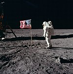 Buzz Aldrin hälsar USA:s flagga vid Mare Tranquillitatis under Apollo 11s uppdrag 1969.
 En vy uppifrån av Mare Tranquillitatis där soluppgången visar en månkrater med klippblock på en annars slät månyta. Bilden visar ett område på 400 meters bredd med norr uppåt på bilden.
Referenser
- ^ John Wilkinson (2010) (på engelska). The Moon in Close-up: A Next Generation Astronomer's Guide. The Patrick Moore Practical Astronomy Series. Springer Science & Business Media. sid. 193. ISBN 978-36-42148-05-7. https://books.google.se/books?id=T_8HX-6itOIC&pg=PA193&lpg=PA193&dq=Beskrivning+Mare+Tranquillitatis&source=bl&ots=dB1CI1UqWM&sig=ACfU3U1iB6Ji9U-TgNnZFbOSm_gEH9ZJLQ&hl=sv&sa=X&ved=2ahUKEwjm_sPej8XiAhVLwqYKHcszBN8Q6AEwDXoECAkQAQ#v=onepage&q=Beskrivning%20Mare%20Tranquillitatis&f=false. Läst 31 maj 2019
- ^ ”Capturing the Colors of the Moon” (på engelska). Sky and Telescope: sid. 120-122. juli 2005. Arkiverad från originalet den 20 oktober 2014. https://web.archive.org/web/20141020135311/https://www.sctxca.org/export/sites/default/clubs-groups/sites/photog/Workshops/Reference_Materials/Technical_Presentations/moon_article_tom_barry.pdf. Läst 29 maj 2019.
- ^ P. M. Muller, W. L. Sjogren (1968). ”Mascons: Lunar Mass Concentrations” (på engelska). Science 161 (3842): sid. 680–684. doi:. PMID 17801458.
- ^ Grayzeck, Ed (1 juli 2013). ”Ranger 8” (på engelska). National Space Data Centre. NASA. Arkiverad från originalet den 31 juli 2013. https://www.webcitation.org/6IX45kRRy?url=http://nssdc.gsfc.nasa.gov/nmc/masterCatalog.do?sc=1965-010A. Läst 29 maj 2019.
- ^ ”NASA - NSSDCA - Spacecraft - Details” (på engelska). nssdc.gsfc.nasa.gov. https://nssdc.gsfc.nasa.gov/nmc/spacecraft/display.action?id=1965-010A. Läst 29 maj 2019.
- ^ ”NASA - NSSDCA - Spacecraft – Details” (på engelska). nssdc.gsfc.nasa.gov. https://nssdc.gsfc.nasa.gov/nmc/spacecraft/display.action?id=1967-084A. Läst 29 maj 2019.
- ^ Gaherty, Geoff (19 april 2013). ”How to See Where Astronauts Walked on the Moon” (på engelska). Space.com. https://www.space.com/20739-apollo-moon-landing-sites-telescope.html. Läst 29 maj 2019.
- ^ (på engelska) The Face of the Moon. Linda Hall Library, Kansas City, MO. 1989. sid. 7. http://www.lindahall.org/events_exhib/exhibit/exhibits/moon/index.html. Läst 29 maj 2019 Arkiverad 6 januari 2012 hämtat från the Wayback Machine.
- ^ ”Mare Tranquillitatis naming origin” (på engelska). Lunar Planetary Institute. https://twitter.com/MyMoonLPI/status/164879359793037312. Läst 29 maj 2019.
Externa länkar
 Wikimedia Commons har media som rör Mare Tranquillitatis.
Media som används på denna webbplats

(c) Gregory H. Revera, CC BY-SA 3.0
Full Moon photograph taken 10-22-2010 from Madison, Alabama, USA. Photographed with a Celestron 9.25 Schmidt-Cassegrain telescope. Acquired with a Canon EOS Rebel T1i (EOS 500D), 20 images stacked to reduce noise. 200 ISO 1/640 sec.

Spectacular high Sun view of the Mare Tranquillitatis pit crater revealing boulders on an otherwise smooth floor. Image is 400 meters wide, north is up, NAC M126710873R.
When the Sun is well overhead, the floor of the Mare Tranquillitatis pit is illuminated. With an incidence angle of 26.5° and a shadow of 55 meters (180 feet), scientists can estimate the depth to be a bit over 100 meters (328 feet). That estimate is from the edge of the shadow, which begins a slightly downslope from the gradual margin of the pits. When measured from the level of the surrounding mare plain, the depth of the pit is even greater. Compare this depth to the width, which ranges from 100 to 115 meters (328 to 377 feet) across the sharp precipice. NASA's Goddard Space Flight Center built and manages the mission for the Exploration Systems Mission Directorate at NASA Headquarters in Washington. The Lunar Reconnaissance Orbiter Camera was designed to acquire data for landing site certification and to conduct polar illumination studies and global mapping. Operated by Arizona State University, LROC consists of a pair of narrow-angle cameras (NAC) and a single wide-angle camera (WAC). The mission is expected to return over 70 terabytes of image data.
- The description is copied from en:File:Mare Tranquillitatis pit crater.jpg.

Buzz Aldrin salutes the U.S flag on the Moon (mission time: 110:10:33). His fingertips are visible on the far side of his faceplate. Note the well-defined footprints in the foreground. Buzz is facing up-Sun. There is a reflection of the Sun in his visor. At the bottom of Buzz's faceplate, note the white 'rim' which is slightly separated from his neckring. This 'rim' is the bottom of his gold visor, which he has pulled down. We can see the LEC straps hanging down inside of the ladder strut. In the foreground, we can see the foot-grabbing loops in the TV cable. The double crater under Neil's LM window is just beyond the LM shadow.
Photo from Apollo 11 mission to the moon. AS11-37-5437.
en:Mare Tranquillitatis sits within the Tranquillitatis basin. The mare material within the basin consists of basalt in the intermediate to young age group of the Upper Imbrian epoch. The surrounding mountains are thought to be of the Lower Imbrian epoch, but the actual basin is probably Pre-Nectarian. The basin has irregular margins and lacks
a defined multiple-ringed structure. The irregular topography in and near this basin results from the intersection of the Tranquillitatis, Nectaris, Crisium, Fecunditatis, and Serenitatis basins with two throughgoing rings of hypothetical Procellarum basin. Mare Serenitatis is seen in the upper left of the photo below. Palus Somni, on the northeastern rim of the mare, is filled with the basalt that spilled over from Tranquillitatis. This mare also served as the landing
site for Apollo 11, the first manned landing on the Moon.