Mare Orientale
| Mare Orientale | |
|---|---|
 | |
| Lokaliseringsbild av Mare Orientale | |
| Plats | Månen |
| Typ | Hav |
| Månkoordinater | 20° S, 95° V |
| Diameter | 294 km |
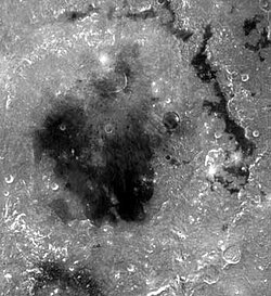
Mare Orientale (på svenska ungefär Östra havet, trots att det ligger på månens västra sida) är ett slättområde på månen belägen på gränsen mellan fram- och baksidan. Slättområdena bildades då stora meteoriter slog ned i månens ursprungliga skorpa och de kratrar som då bildades fylldes med flytande lava från månens inre. Mare Orientales diameter är ca 300 kilometer.
Mare Orientale omges av två ringformiga bergskedjor, en yttre som heter Montes Cordillera och en inre som heter Montes Rook.

Se även
- Lista över månens berg
- Lista över månens hav
- Lista över månens kratrar
Källor
- ”Mare Orientale” (på engelska). International Astronomical Union. 18 oktober 2010. https://planetarynames.wr.usgs.gov/Feature/3685. Läst 31 januari 2024.
Media som används på denna webbplats
en:Mare Orientale straddles both the near and far side. The basin has the most nearly complete concentric ring structure of any basin in the west. The surrounding basin material is of the Lower Imbrian epoch, with the mare material being of the Upper Imbrian epoch. The outermost conspicuous ring is Cordillera, bounded inwardly by steep scarp or gentle lip and topped by some ridgelike massifs. The mare-like material to the northeast is Lacus Autumni. You can also make out the crater Maunder among the northern region of the mare. Off to the southeast of Maunder is Kopff. Montes Rooks lines the eastern edge of the mare.
(c) Gregory H. Revera, CC BY-SA 3.0
Full Moon photograph taken 10-22-2010 from Madison, Alabama, USA. Photographed with a Celestron 9.25 Schmidt-Cassegrain telescope. Acquired with a Canon EOS Rebel T1i (EOS 500D), 20 images stacked to reduce noise. 200 ISO 1/640 sec.
Författare/Upphovsman: User:Silvercat, Licens: CC BY-SA 3.0
The Location of Mare Orientale, One of the Lunar Geographical Features.


