Marblehead, Ohio
| Marblehead | |
(c) User: (WT-shared) 2old at wts wikivoyage, CC BY-SA 4.0 | |
| Land | |
|---|---|
| Delstat | |
| County | Ottawa County |
| Höjdläge | 191 m ö.h. |
| Koordinater | 41°32′4″N 82°43′44″V / 41.53444°N 82.72889°V |
| Area | 11,14 km² (2010)[1] |
| Folkmängd | 865 (2020)[2] |
| Befolkningstäthet | 78 invånare/km² |
| Tidszon | EST (UTC-5) |
| - sommartid | EDT (UTC-4) |
| ZIP-kod | 43440 |
| GNIS-kod | 1065723 |
| Geonames | 5161869 |
Översiktskarta | |
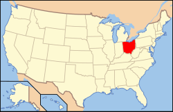
Ohios läge i USA | |
| Wikimedia Commons: Marblehead, Ohio | |
| Redigera Wikidata | |
Marblehead är en ort (village) i Ottawa County i Ohio.[3] Vid 2010 års folkräkning hade Marblehead 903 invånare.[4]
Källor
- ^ United States Census Bureau, 2010 U.S. Gazetteer Files, United States Census Bureau, 2010, läst: 9 juli 2020.[källa från Wikidata]
- ^ United States Census Bureau (red.), USA:s folkräkning 2020, läs online, läst: 1 januari 2022.[källa från Wikidata]
- ^ Marblehead, OH. Map Quest. Läst 25 oktober 2021.
- ^ Marblehead, Ohio. Roadside Thoughts. Läst 25 oktober 2021.
|
Media som används på denna webbplats
Författare/Upphovsman: Catbar på engelska Wikipedia, Licens: CC BY-SA 3.0
Map of Marblehead.
(c) User: (WT-shared) 2old at wts wikivoyage, CC BY-SA 4.0
Marblehead OH Lighthouse 05-28-07 By:Mike Sharp.
Författare/Upphovsman: This version: uploader
Base versions this one is derived from: originally created by en:User:Wapcaplet, Licens: CC BY 2.0
Map of USA with Ohio highlighted


