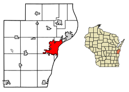
Manitowoc
| Manitowoc | |
| Stad (city) | |
| Land | |
|---|---|
| Delstat | |
| County | Manitowoc County |
| Höjdläge | 184 m ö.h.[1] |
| Koordinater | 44°5′57″N 87°40′52″V / 44.09917°N 87.68111°V |
| Area | 46,59 km² (2010)[3] |
| Folkmängd | 34 626 (2020)[4] |
| Befolkningstäthet | 743 invånare/km² |
| Borgmästare | Justin M. Nickels (2021–)[2] |
| Tidszon | CST (UTC-6) |
| - sommartid | CDT (UTC-5) |
| ZIP-kod | 54220 |
| Riktnummer | 608 |
| GNIS-kod | 1568942 |
| Geonames | 5261585 |
Översiktskarta | |
Wisconsins läge i USA | |
| Wikimedia Commons: Manitowoc, Wisconsin | |
| Webbplats: https://www.manitowoc.org/ | |
| Redigera Wikidata | |

Manitowoc är en stad i Manitowoc County, Wisconsin, USA. Staden ligger vid Lake Michigan utmed Manitowocfloden. Enligt folkräkningen år 2000 har staden en befolkning på 34,053. Manitowoc är administrativ huvudort (county seat) i Manitowoc County.
Bland företag i staden är The Manitowoc Company, Burger Boat Company, Bio-Blend Fuels och Orion Energy Systems.
Kända personer
- Steven Avery
- Henry Baetz
- Gerald W. Clusen
- E. H. Ellis, borgmästare
- Charles E. Estabrook
- Peter Fanta
- Doug Free
- Edgar A. Jonas
- Ardis Krainik
- Francis J. Lallensack
- Stoney McGlynn, MLB-spelare.[5]
Tvillingstad
- Kamogawa.
Referenser
- ^ Geographic Names Information System, läst: 7 april 2021.[källa från Wikidata]
- ^ läs online, www.manitowoc.org , läst: 4 september 2024.[källa från Wikidata]
- ^ United States Census Bureau, 2010 U.S. Gazetteer Files, United States Census Bureau, 2010, läst: 9 juli 2020.[källa från Wikidata]
- ^ United States Census Bureau (red.), USA:s folkräkning 2020, läs online, läst: 1 januari 2022.[källa från Wikidata]
- ^ ”Stoney McGlynn Statistics and History”. Baseball-Reference.com. http://www.baseball-reference.com/players/m/mcglyst01.shtml. Läst 6 augusti 2010.
Externa länkar
 Wikimedia Commons har media som rör Manitowoc.
- Manitowoc, Wisconsin
- Manitowoc-Two Rivers Area Chamber of Commerce
- Manitowoc Public Library
- Manitowoc Public School District
|
Media som används på denna webbplats
Författare/Upphovsman: Jonathunder, Licens: GFDL 1.2
Manitowoc River, near where it enters Lake Michigan, reflecting the skyline of downtown Manitowoc, Wisconsin, with the U.S. 10 highway bridge at left.
Författare/Upphovsman: This version: uploader
Base versions this one is derived from: originally created by en:User:Wapcaplet, Licens: CC BY 2.0
Map of USA with Wisconsin highlighted
Författare/Upphovsman: Chris Rand, Licens: CC BY-SA 4.0
The Manitowoc Rivers empties into Lake Michigan.
(c) DemocraticLuntz på engelska Wikipedia, CC BY-SA 4.0
Location of Manitowoc in Manitowoc County, Wisconsin.
FIPS code: 55-48500
Own work, based on concept by Arkyan, using Census Bureau Tiger GIS data and a custom fork of Kartography adapted for this purpose, available at


