Málmiesjávrrie
| Land | |
|---|---|
| Län | Norrbottens län |
| Kommun | Arvidsjaurs kommun |
| Landskap | Lappland |
| Socken | Arvidsjaurs socken |
| Koordinater | |
| WGS 84 | 65°54′39″N 19°13′50″Ö / 65.91087°N 19.23047°Ö |
| SWEREF 99 TM | 7316469, 692560 |
| Mått | |
| Areal | 13,7 km² [1] |
| Höjd | 334 m ö.h. [2] |
| Strandlinje | 35,9 km [2] |
| Flöden | |
| Huvudavrinningsområde | Piteälvens huvudavrinningsområde (13000) |
| Utflöde | Abmoälven |
| VattendragsID (VDRID) | 732379-166394 |
| GeoNames | 2692982 |
| Status[1] | |
| Ekologisk status | |
| Kemisk status (exkl. kvicksilver) | |
| Miljöproblem[2] | |
| Försurning | |
| Övergödning | |
| Miljögifter (exkl. kvicksilver) | |
| Främmande arter | |
| Flödesförändringar | |
| Kontinuitetsförändringar | |
| Morfologiska förändringar | |
| Källa | VISS (SE731467-166348) |
| Övrigt | |
| SjöID | 731467-166348 |
| ID vattenförekomst | SE731467-166348 |
| Vattenytans ID (VYID) | 731653-165602 |
| Vattendistrikt | Vattenmyndigheten Bottenviken (SE1) |
| Natura 2000 | Piteälven (SE0820434)[3] |
| Limnisk ekoregion | Norrlands inland, under trädgränsen över högsta kustlinjen |
| Delavrinningsområde | |
| Delavrinning ID (AROID) | 731586-165685 |
| Namn | Utloppet av Malmesjaure |
| Areal | 62,83 km² |
| Vattenytor | 13,86 km² |
| Sjöprocent | 22,06 % |
| Ackumulerad areal uppströms | 924,39 km² |
| Biflödesordning | 2 |
| Utflöde | Abmoälven |
| VattendragsID (VDRID) | 732379-166394 |
| Avstånd till havet | 152 km |
| Medelhöjd | 380 m ö.h. |
| Område nedströms | 731485-166487 |
| Källor | [4][5][6] |
Málmiesjávrrie är en sjö norr om Moskosel i Arvidsjaurs kommun i Lappland som ingår i Piteälvens huvudavrinningsområde. Sjön har en area på 13,7 kvadratkilometer och ligger 334 meter över havet. Málmiesjávrrie ligger i Piteälven Natura 2000-område.[3] Sjön avvattnas av vattendraget Abmoälven.
Sjön är egentligen en uppdämning av Abmoälven. Vid sjön anlades ett krigsflygbas under andra världskriget, en av många småbaser som skapades för att kunna ta emot flygplan under beredskapsåren och det kalla kriget.
Delavrinningsområde
Málmiesjávrrie ingår i delavrinningsområde (731586-165685) som SMHI kallar för Utloppet av Malmesjaure. Medelhöjden är 380 meter över havet och ytan är 62,83 kvadratkilometer. Räknas de 66 avrinningsområdena uppströms in blir den ackumulerade arean 924,39 kvadratkilometer. Abmoälven som avvattnar avrinningsområdet har biflödesordning 2, vilket innebär att vattnet flödar genom totalt 2 vattendrag innan det når havet efter 152 kilometer.[6] Avrinningsområdet består mestadels av skog (71 procent). Avrinningsområdet har 13,86 kvadratkilometer vattenytor vilket ger det en sjöprocent på 22,1 procent.[5]
Se även
Källor
- ^ ”Sjölyftet” (Microsoft Excel). SMHI. http://www.smhi.se/polopoly_fs/1.11384!Sjolista.xls. Läst 10 december 2012.
- ^ [a b] ”Ladda ner data från Svenskt vattenarkiv – Vattenytor (SVAR 2012)” (Esri Shape). SMHI. http://www.smhi.se/polopoly_fs/1.31148!/Menu/general/extGroup/attachmentColHold/mainCol1/file/Vy_y_2012_2c.zip. Läst 7 oktober 2012.
- ^ [a b] ”Naturvårdsverkets sammanställning av Natura 2000-områden” (Esri Shape). Naturvårdsverket. http://gis-services.metria.se/nvfeed/atom/annex1.xml. Läst 7 oktober 2012.
- ^ ”Ladda ner data från Svenskt vattenarkiv – Ackumulerade delavrinningsområden (SVAR 2010)” (Esri Shape). SMHI. http://www.smhi.se/polopoly_fs/1.22092!svaro_2010_2.zip. Läst 7 oktober 2012.
- ^ [a b] ”Ladda ner data från Svenskt vattenarkiv – delavrinningsområden (SVAR 2010)” (Esri Shape). SMHI. http://www.smhi.se/polopoly_fs/1.20768!/Menu/general/extGroup/attachmentColHold/mainCol1/file/aro_y_2010_2.zip. Läst 7 oktober 2012.
- ^ [a b] ”Ladda ner data från Svenskt vattenarkiv – Delavrinningsområden (SVAR 2012)” (Esri Shape). SMHI. http://www.smhi.se/polopoly_fs/1.24469!/Menu/general/extGroup/attachmentColHold/mainCol1/file/aro_y_2012_2.zip. Läst 7 oktober 2012.
Externa länkar
Media som används på denna webbplats
Författare/Upphovsman: Silverkey (Mickaël Delcey), Licens: CC BY-SA 4.0
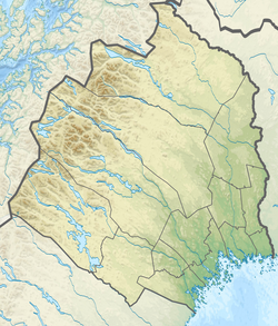
Topographic location map of Norrbotten county in Sweden
Equirectangular projection, N/S stretching 257 %. Geographic limits of the map:
- N: 69.10° N
- S: 64.90° N
- W: 15.10° E
- E: 24.30° E
Shiny red button/marker widget. Used to mark the location of something such as a tourist attraction.
Gul kvadrat (#FFF685)
Blå kvadrat (#52B4D0)
Grön kvadrat (#80B682)
Röd kvadrat (#F2716D)


