Mafeteng
| Mafeteng | |
| Distriktshuvudort | |
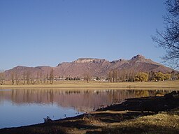
Utsikt mot Likhoele som är näst högsta berget i Mafeteng. | |
| Land | |
|---|---|
| Distrikt | Mafeteng District |
| Höjdläge | 1 669 m ö.h. |
| Koordinater | 29°49′21″S 27°14′20″Ö / 29.82250°S 27.23889°Ö |
| Folkmängd | 57 059från frwiki |
| Tidszon | CAT (UTC+2) |
| IATA-kod | MFC |
| Geonames | 932614 |
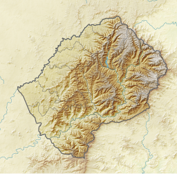
Läge i Lesotho | |
Mafeteng är en ort i Lesotho och huvudstad i Mafetengdistriktet. Orten ligger ungefär 76 km söder om huvudstaden Maseru och har cirka 60 000 invånare.
Terrängen runt Mafeteng är platt åt nordväst, men åt sydost är den kuperad.[1]
Källor
- ^ ”Viewfinder Panoramas Digital elevation Model”. http://www.viewfinderpanoramas.org/dem3.html. Läst 21 juni 2015.
Media som används på denna webbplats
Författare/Upphovsman:
- File:Lesotho location map.svg by Spischot
- derivative work by Htonl
Relief location map of Lesotho
Equirectangular projection. Geographic limits of the map:
- N: 28.33° S
- S: 30.89° S
- W: 26.74° E
- E: 29.62° E
Shiny red button/marker widget. Used to mark the location of something such as a tourist attraction.
(c) Eraserhead03 from en.wikipedia.org, CC BY-SA 3.0
A view of Likhoele (elevation 6,915 feet), Mafeteng's second highest mountain, from the reservoir by Kingsgate Primary School


