M1 (Storbritannien)
| Motorväg | |
 | |
| M1 | |
| Basfakta | |
|---|---|
| Land | Storbritannien |
| Del av | |
| Längd | 311,4 [1] km |
| Geografiska fakta | |
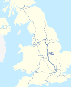
Nilfanion and Dr Greg. © OpenStreetMap contributors. Contains Ordnance Survey data © Crown copyright and database right 2010., CC BY-SA 4.0 | |
| Börjar i | London |
| Slutar i | Hook Moor (311,4 [1] km) |

M1 är en motorväg i Storbritannien som går mellan London och Wetherby i West Yorkshire. Från Wetherby leder A1 vidare norrut till Edinburgh. Den passerar St Albans, Luton, Milton Keynes, Leicester, Nottingham, Sheffield och Leeds. M1 var Storbritanniens första längre motorväg (den första motorvägen var den korta snutten som idag är M6 förbi Preston som öppnades 1958). M1 är även en av landets viktigaste motorvägar och är startpunkten för M6 som passerar genom bland annat Birmingham och Manchester.
Trafikplatser
| Nr | Skyltning | |
| 1 | 406 West End | |
| 2 | 1 City of London | |
| London Gateway (Scratchwood) | ||
| 4 | 41 Edgware | |
| 5 | 41 Watford, Harrow, Aylesbury | |
| 6 | 405 Watford, St Albans, Stansted, Dartford, Heathrow | |
| 6A | ||
| 7 | 414 St Albans, Hatfield | |
| 8 | 414 Hemel Hempstead | |
| 9 | 5 5183 Dunstable, Redbourn | |
| 10 | 1081 Luton, Luton Airport | |
| 11 | 505 Luton, Dunstable | |
| Toddington | ||
| 12 | 5120 Flitwick, Woburn, Houghton Regis | |
| 13 | 421 507 Milton Keynes, Bedford, Ampthill | |
| 14 | 509 Milton Keynes, Newport Pagnell | |
| Newport Pagnell | ||
| 15 | 45 Northampton | |
| 15A | 43 Northampton, Oxford | |
| Rothersthorpe | ||
| 16 | 45 4500 Northampton, Daventry | |
| 17 | ||
| 18 | 5 428 Daventry, Hinckley, Rugby | |
| 19 | ||
| 20 | 303 4304 Lutterworth, Market Harborough, Rugby | |
| 21 | ||
| Leicester Forest East | ||
| 21A | 46 Leicester, Newark-on-Trent | |
| 22 | 50 511 Ashby, Coalville, Leicester | |
| 23 | 512 Loughborough, Ashby, East Midlands Airport, Stoke, Derby | |
| 23A | 6 42 50 453 Sydvästra England, Tamworth, Birmingham | |
| Donington Park | ||
| 24 | 46 453 Nottingham, East Midlands Airport, Loughborough | |
| 24A | 50 Derby, Stoke | |
| 25 | 52 Nottingham, Derby, Ilkeston | |
| Trowell | ||
| 26 | 610 Nottingham, Ripley, Ilkeston | |
| 27 | 608 Mansfield, Heanor, Hucknall | |
| 28 | 38 Mansfield, Matlock, Derby | |
| Tibshelf | ||
| 29 | 617 Chesterfield, Mansfield, Matlock | |
| 29A | 6192 Markham Vale, Bolsover | |
| 30 | 616 6135 Sheffield, Worksop, Chesterfield, Newark | |
| Woodall | ||
| 31 | 57 Worksop | |
| 32 | ||
| 33 | 630 Sheffield, Rotherham | |
| 34 | 631 6109 6178 Sheffield, (Meadowhall) Rotherham | |
| 35 | 629 Rotherham | |
| 35A | 616 Manchester | |
| 36 | 61 Barnsley, Sheffield | |
| 37 | 628 Barnsley, Manchester | |
| 38 | 628 Huddersfield | |
| Woolley Edge | ||
| 39 | 636 Wakefield, Denby Dale | |
| 40 | 638 Dewsbury, Batley, Wakefield | |
| 41 | 650 Wakefield, Morley | |
| 42 | ||
| 43 | ||
| 44 | 639 Leeds | |
| 45 | 63 Leeds | |
| 46 | 63 6120 Leeds, Leeds Bradford Airport, Selby | |
| 47 | 642 656 Garforth, Castleford | |
| 48 | ||
| Vidare på |
Referenser
Se även
- Lista över motorvägar i Storbritannien
Externa länkar
| ||||||||
Media som används på denna webbplats
Gas station symbol
Motorway badge for the M621 motorway
Motorway badge for the M62 motorway
Motorway badge for the M25 motorway
Motorway badge for the M69 motorway
Författare/Upphovsman: Klaus with K, Licens: CC BY-SA 3.0
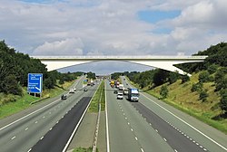
M1 in Yorkshire south of Leeds.
Motorway badge for the A1 (M) motorway
Motorway badge for the M45 motorway
Motorway badge for the M18 motorway
Nilfanion and Dr Greg. © OpenStreetMap contributors. Contains Ordnance Survey data © Crown copyright and database right 2010., CC BY-SA 4.0
The M1 motorway of Great Britain highlighted against the motorways of the United Kingdom in 2016. Equirectangular map projection on WGS 84 datum.
Motorway badge for the M1 motorway
Motorway badge for the M6 motorway


