Münchwilen, Aargau
| Münchwilen AG | ||
| tyska: Gemeinde Münchwilen | ||
| Kommun | ||
Münchwilen | ||
| ||
| Land | ||
|---|---|---|
| Kanton | Aargau | |
| Distrikt | Laufenburg | |
| Höjdläge | 342 m ö.h. | |
| Koordinater | 47°32′17″N 07°57′47″Ö / 47.53806°N 7.96306°Ö | |
| Yta | 2,46 km²[1] | |
| Folkmängd | 1 019 (2021-12-31)[2] | |
| Befolkningstäthet | 414 inv./km² | |
| Tidszon | CET (UTC+1) | |
| - sommartid | CEST (UTC+2) | |
| Postnummer | 4333 | |
| Kommunkod | 4172 | |
| Geonames | 7286586 | |
| Språk | Tyska | |
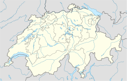
Münchwilens läge i Schweiz | ||
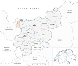
Detaljkarta | ||
| Webbplats: www.muenchwilen-ag.ch | ||
Münchwilen (schweizertyska: Münchwyle) är en ort och kommun i distriktet Laufenburg i kantonen Aargau, Schweiz. Kommunen har 1 019 invånare (2021).[2]
Referenser
- ^ ”Arealstatistik Standard - Gemeinden nach 4 Hauptbereichen” (på tyska/franska). Bundesamt für Statistik. 25 november 2021. https://dam-api.bfs.admin.ch/hub/api/dam/assets/19805706/master.
- ^ [a b] ”Bilanz der ständigen Wohnbevölkerung nach Bezirken und Gemeinden, 1991-2021” (på tyska/franska/italienska). Bundesamt für Statistik. 25 augusti 2022. https://dam-api.bfs.admin.ch/hub/api/dam/assets/23064893/master.
Externa länkar
 Wikimedia Commons har media som rör Münchwilen.
| |||||||||||
Media som används på denna webbplats
Författare/Upphovsman: NordNordWest, Licens: CC BY-SA 3.0
Location map of Switzerland
Shiny red button/marker widget. Used to mark the location of something such as a tourist attraction.
Författare/Upphovsman: Tschubby, Licens: CC BY-SA 3.0
Municipality Münchwilen
Författare/Upphovsman: Heitersberg, Licens: CC BY-SA 4.0
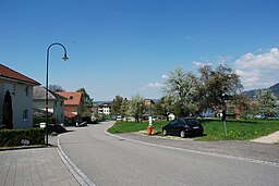
Münchwilen AG Blick Richtung Stein AG


