Münchringen
| Münchringen | ||
| Ort | ||
Münchringen | ||
| ||
| Land | ||
|---|---|---|
| Kanton | Bern | |
| Distrikt | Bern-Mittelland | |
| Kommun | Jegenstorf | |
| Höjdläge | 522 m ö.h. | |
| Koordinater | 47°2′39″N 7°31′18″Ö / 47.04417°N 7.52167°Ö | |
| Yta | 2,4 km²[1] | |
| Folkmängd | 587 (2009-12-31)[2] | |
| Befolkningstäthet | 245 inv./km² | |
| Tidszon | CET (UTC+1) | |
| - sommartid | CEST (UTC+2) | |
| Postnummer | 3303 | |
| Kommunkod | 0547 | |
| Geonames | 8533524 | |
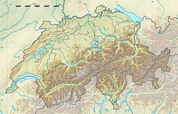
Münchringens läge i Schweiz | ||
Kommunindelning innan sammanslagningen | ||
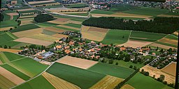
Münchringen är en ort i kommunen Jegenstorf i kantonen Bern, Schweiz.
Münchringen var tidigare en självständig kommun, men den 1 januari 2014 blev den en del av kommunen Jegenstorf.
Källor
- ^ ”Statistique de la superficie 2004/09 : Données communales” (på tyska & franska) (Excel). Office fédéral de la Statistique. Arkiverad från originalet den 14 maj 2011. https://web.archive.org/web/20110514110918/http://www.bfs.admin.ch/bfs/portal/fr/index/themen/02/03/blank/data/gemeindedaten.Document.87942.xls. Läst 23 september 2010.
- ^ ”Bilan de la population résidante permanente (total) selon les districts et les communes, en 2009” (på franska) (Excel). Office fédéral de la Statistique. Arkiverad från originalet den 6 augusti 2011. https://web.archive.org/web/20110806213408/http://www.bfs.admin.ch/bfs/portal/fr/index/themen/01/02/blank/data/01.Document.67224.xls. Läst 1 september 2010.
Media som används på denna webbplats
Författare/Upphovsman: Eric Gaba (Sting - fr:Sting) and NordNordWest, Licens: CC BY-SA 3.0
Blank physical map of Switzerland, for geo-location purpose. More maps: → Maps of Switzerland.
Shiny red button/marker widget. Used to mark the location of something such as a tourist attraction.
Författare/Upphovsman: Tschubby, Licens: CC BY-SA 3.0
Municipality Münchringen
Författare/Upphovsman: Aliman5040, Licens: CC BY-SA 3.0
coat of arms of the municipality of Münchringen (Switzerland)
Författare/Upphovsman:
Aerial photograph of Münchringen, 1997


