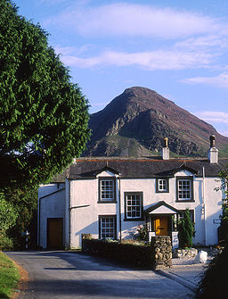
Loweswater (by)
| Loweswater | |
(c) Tom Richardson, CC BY-SA 2.0 Loweswater | |
| Land | |
|---|---|
| Riksdel | England |
| Region | Nordvästra England |
| Ceremoniellt grevskap | Cumbria |
| Enhetskommun | Cumberland |
| Koordinater | 54°34′34″N 3°19′47″V / 54.5761°N 3.3296°V |
| Tidszon | GMT (UTC+0) |
| Riktnummer | 01946 |
| Geonames | 2643489 7298892 |
Loweswater är en by och en civil parish i Cumbria i England. Orten har 209 invånare (2001).[1]
En kilometer väster om byn ligger sjön Loweswater.
Referenser
- ^ Neighbourhood statistics Arkiverad 17 december 2014 hämtat från the Wayback Machine.
Externa länkar
Media som används på denna webbplats
Författare/Upphovsman: Alexrk2, Licens: CC BY-SA 3.0
Location map of the United Kingdom
Shiny red button/marker widget. Used to mark the location of something such as a tourist attraction.
(c) Tom Richardson, CC BY-SA 2.0
The Kirkstile Inn, at Loweswater in the English county of Cumbria. Mellbreak can be seen towering above the hotel. For more information see the Wikipedia articles Loweswater, Cumbria and Mellbreak.


