Los Angeles County
| Los Angeles County | |||
| County | |||
| |||
| Land | |||
|---|---|---|---|
| Delstat | |||
| Huvudort | Los Angeles | ||
| Area | 12 305 km² (2010)[1] | ||
| - land | 10 510 km² (85%) | ||
| - vatten | 1 795 km² (15%) | ||
| Folkmängd | 9 818 605 (2010)[2] | ||
| Befolkningstäthet | 934 invånare/km² | ||
| Grundat | 18 februari 1850 | ||
| Tidszon | PST (UTC-8) | ||
| - sommartid | PDT (UTC-7) | ||
| FIPS-kod | 06037 | ||
| Geonames | 5368381 | ||
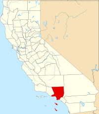
Läge i delstaten Kalifornien. | |||
Delstatens läge i USA. | |||
Los Angeles County är ett county i delstaten Kalifornien, USA. Den administrativa huvudorten (county seat) är Los Angeles.
Countyt omfattar de centrala delarna Los Angeles storstadsområde med drygt 10,2 miljoner invånare (den 1 januari 2006). Countyt består av 88 städer, till vilka de mest kända hör Los Angeles, Beverly Hills, Santa Monica, Inglewood, West Hollywood och Long Beach. Los Angeles County utgör numera endast en del av det storstadsområde som kallas Los Angeles. Angränsade countyn är Orange County, San Bernardino County, Riverside County, Kern County och Ventura County.
Geografi
Enligt United States Census Bureau så har countyt en total area på 12 308 km². 10 518 km² av den arean är land och 1 791 km² är vatten.
Angränsande countyn
- Ventura County, Kalifornien - väst
- Kern County, Kalifornien - nord
- San Bernardino County, Kalifornien - öst
- Orange County, Kalifornien - sydost
De största städerna i Los Angeles County

- Los Angeles 4 018 080
- Long Beach 492 912
- Glendale 207 157
- Santa Clarita 177 158
- Pomona 162 140
- Torrance 148 558
- Pasadena 147 262
- Palmdale 145 468
- Lancaster 143 818
- El Monte 126 282
- Inglewood 119 212
- Downey 113 587
- West Covina 112 953
- Norwalk 110 040
- Burbank 107 921
Den minsta staden i Los Angeles County
- Vernon 91
Förvaltning
Förvaltningen på county-nivå i Los Angeles County leds kollektivt av Los Angeles County Board of Supervisors.[3]
Befolkning
Av Los Angeles Countys befolkning beräknades 14,4% leva under fattigdomsgränsen (år 2007) jämfört med 13,1 % för hela USA och 13,3% för Kalifornien [1]
Se även
- Azusa
- Duarte, Kalifornien
- Los Angeles County Fire Department
- Los Angeles County Lifeguards
- Los Angeles County Sheriff's Department
- Metrolink (Kalifornien)
- Signal Hill, Kalifornien
Referenser
- ^ ”2010 Census U.S. Gazetteer Files for Counties”. U.S. Census Bureau. Arkiverad från originalet den 5 juli 2012. https://www.webcitation.org/68vYLbou5?url=http://www.census.gov/geo/www/gazetteer/files/Gaz_counties_national.txt. Läst 5 juli 2012.
- ^ ”State & County QuickFacts, Los Angeles County, Kalifornien” (på engelska). U.S. Census Bureau. Arkiverad från originalet den 14 juli 2011. https://www.webcitation.org/60AGlrP3B?url=http://quickfacts.census.gov/qfd/states/06/06037.html. Läst 6 juli 2011.
- ^ ”Responsibilities of the Board of Supervisors” (på engelska). Executive Office of the Board of Supervisors. https://file.lacounty.gov/SDSInter/lac/1031549_BoardResponsibilities.pdf. Läst 20 december 2021.
Externa länkar
| ||||||||||
Media som används på denna webbplats
Flag of California. This version is designed to accurately depict the standard print of the bear as well as adhere to the official flag code regarding the size, position and proportion of the bear, the colors of the flag, and the position and size of the star.
Författare/Upphovsman: Huebi, Licens: CC BY 2.0
Map of USA with California highlighted
This map shows the incorporated areas in Los Angeles County, California. Los Angeles is highlighted in red. I created it in Inkscape using data from the Los Angeles County Website (Los Angeles County Incorporated Area and District Map (PDF).
The flag of Los Angeles County — in Southern California. Used from 2004 to 2014 and from 2016 to the present.
- The current "Los Angeles County flag". It consists of the Los Angeles County seal on a rich blue background, with the words "COUNTY OF LOS ANGELES" on a green stripe across the bottom.
The current seal of Los Angeles County, California (used from 2004 to 2014 and 2016 to present), e.g. "L.A. County seal", adopted by the Los Angeles County Board of Supervisors in September 2004 and readopted in 2016. It replaced the L.A. County seal that was adopted in March 1957 and January 2014.
A locator map showing Los Angeles County — in Southern California.


