Livingstonön
| Livingstonön | |
| Livingston Island | |
| Ö | |
 Kartan markerar Livingstonön i Sydshetlandsöarna | |
| Land | |
|---|---|
| Arkipelag | Sydshetlandsöarna |
| Läge | Livingston Island |
| - koordinater | 62°36′0″S 60°30′0″V / 62.60000°S 60.50000°V |
| Längd | 73 km |
| Bredd | 34 km |
| Höjd | 1 700 m |
| Area | 798 km² |
| Geonames | 6620723 |
Livingstonön (engelska: Livingston Island), historiskt namn på ryska: Smolensk, är en ö i Antarktis, som ingår i Sydshetlandsöarna. Den upptäcktes 1819 av kapten William Smith[1], och när den första ryska antarktisexpeditionen passerade området i januari 1821, fann man en stor mängd amerikanska och brittiska sälfångstfartyg. Ryssarna kallade ön Smolensk, men namnet Livingston Island, vars ursprung är obekant, har blivit internationellt vedertaget.
På ön ligger två permanenta forskningsstationer, som båda upprättades 1988: spanska Juan Carlos I och bulgariska St. Kliment Ohridski.
De allra flesta kryssningar till Antarktis passerar Sydshetlandsöarna, och många turister vandrar på Hannah Point, en kustremsa på södra delen av ön.
Bildgalleri
 Mount Friesland når en höjd av 1700 m.
 Många turister besöker Hannah Point.
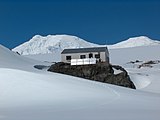 Den bulgariska forskningsstationen St. Kliment Ohridski
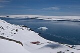 Den spanska forskningsstationen Juan Carlos I

Källor
- Den här artikeln är helt eller delvis baserad på material från engelskspråkiga Wikipedia, Livingston Island, 1 juli 2013.
Fotnoter
- ^ ”Introducing Livingston Island” (på engelska). Lonely Planet. https://www.lonelyplanet.com/livingston-island. Läst 1 januari 2016.
Externa länkar
 Wikimedia Commons har media som rör Livingstonön.
- Ivanov, L. General Geography and History of Livingston Island. In: Bulgarian Antarctic Research: A Synthesis. Eds. C. Pimpirev and N. Chipev. Sofia: St. Kliment Ohridski University Press, 2015. pp. 17–28. ISBN 978-954-07-3939-7
- Ivanov, L.L. Livingston Island: Tangra Mountains, Komini Peak, west slope new rock route; Lyaskovets Peak, first ascent; Zograf Peak, first ascent; Vidin Heights, Melnik Peak, Melnik Ridge, first ascent. The American Alpine Journal, 2005. pp. 312–315.
- Gildea, D. Mountaineering in Antarctica: complete guide: Travel guide. Primento and Editions Nevicata, 2015. ISBN 978-2-51103-136-0
Media som används på denna webbplats
.svg)
Flag of Antarctica.svg
Författare/Upphovsman: Tobias Jakobs (in the public domain)., Licens: CC0
One of several flag proposals for Antarctica.
Författare/Upphovsman: Tobias Jakobs (in the public domain)., Licens: CC0
One of several flag proposals for Antarctica.
Proposed flag of Antarctica (Graham Bartram).svg
Författare/Upphovsman: Tobias Jakobs (in the public domain)., Licens: CC0
One of several flag proposals for Antarctica.
Författare/Upphovsman: Tobias Jakobs (in the public domain)., Licens: CC0
One of several flag proposals for Antarctica.

Renier.jpg
Författare/Upphovsman: User:Apcbg, Licens: CC BY-SA 4.0
Renier Point, the east extremity of Burgas Peninsula and Livingston Island in the South Shetland Islands; photo taken from ROU Vanguardia
Författare/Upphovsman: User:Apcbg, Licens: CC BY-SA 4.0
Renier Point, the east extremity of Burgas Peninsula and Livingston Island in the South Shetland Islands; photo taken from ROU Vanguardia
- Viewpoint location: ROU Vanguardia, Uruguayan Navy in Bransfield Strait off Livingston Island, in the South Shetland Islands
- Viewpoint elevation: 5 meters
- Camera: HP PhotoSmart C945 (V01.54)
Livingston-Island-Map-2010-15.png
Författare/Upphovsman: Apcbg, Licens: CC BY-SA 4.0
L.L. Ivanov. Antarctica: Livingston Island and Smith Island. Scale 1:100000 topographic map. Manfred Wörner Foundation, 2017. ISBN 978-619-90008-3-0
Författare/Upphovsman: Apcbg, Licens: CC BY-SA 4.0
L.L. Ivanov. Antarctica: Livingston Island and Smith Island. Scale 1:100000 topographic map. Manfred Wörner Foundation, 2017. ISBN 978-619-90008-3-0

Ohridski-Livingston.jpg
Författare/Upphovsman: Lyubomir Ivanov, Licens: GPL
Bulgarian base St. Kliment Ohridski on Livingston Island, with Mount Friesland in the background.
Författare/Upphovsman: Lyubomir Ivanov, Licens: GPL
Bulgarian base St. Kliment Ohridski on Livingston Island, with Mount Friesland in the background.
- Viewpoint location: Swan Beach on Livingston Island, in the South Shetland Islands
- Viewpoint elevation: 3 meters
- View direction: east-southeast
- Camera: HP PhotoSmart C945 (V01.54)

Hannah-Point.jpg
Författare/Upphovsman: Lyubomir Ivanov, Licens: GPL
Liverpool Beach at Hannah Point on Livingston Island in the South Shetland Islands, one of the most popular tourist sites in Antarctica.
Författare/Upphovsman: Lyubomir Ivanov, Licens: GPL
Liverpool Beach at Hannah Point on Livingston Island in the South Shetland Islands, one of the most popular tourist sites in Antarctica.
- Viewpoint location: Hannah Point, the northwest side of the entrance to South Bay, Livingston Island in the South Shetland Islands
- Viewpoint elevation: 2 meters
- View direction: north
- Camera: HP PhotoSmart C945 (V01.54)

Juan Carlos I Antarctic Base, Hurd Peninsula, Livingston Island, Antarctica.jpg
Författare/Upphovsman: Polarguide., Licens: CC BY-SA 3.0
Juan Carlos I Antarctic Station, a seasonal scientific station operated by Spain on the Hurd Peninsula, on Livingston Island in the South Shetland Islands, Antarctica. In the background are South Bay and Ereby Point.
Författare/Upphovsman: Polarguide., Licens: CC BY-SA 3.0
Juan Carlos I Antarctic Station, a seasonal scientific station operated by Spain on the Hurd Peninsula, on Livingston Island in the South Shetland Islands, Antarctica. In the background are South Bay and Ereby Point.
Livingston-Island-location-map.png
Författare/Upphovsman: Apcbg, Licens: CC BY-SA 3.0
Location map of Livingston Island in the South Shetland Islands.
Författare/Upphovsman: Apcbg, Licens: CC BY-SA 3.0
Location map of Livingston Island in the South Shetland Islands.

Presian.jpg
Författare/Upphovsman: Lyubomir Ivanov alias User:Apcbg, Licens: CC BY-SA 4.0
The summit Mount Friesland (1700 m) in Tangra Mountains on Livingston Island in the South Shetland Islands, with Presian Ridge in the foreground, and the ‘Synagogue’ (a rock-cored ice form rising in the saddle between Mount Friesland and St. Boris Peak) in the background.
- Viewpoint location: West slopes of Lyaskovets Peak in Tangra Mountains on Livingston Island, in the South Shetland Islands
- Viewpoint elevation: 1380 meters
- Camera: HP PhotoSmart C945 (V01.54)