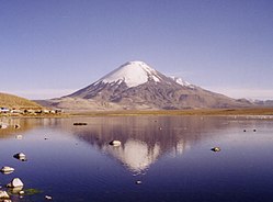
Lista över vulkaner i Bolivia

Illimani
Parinacota
Sajama

Detta är en lista över vulkaner i Bolivia.

NamnHöjd
(m ö.h.)
KoordinaterSenaste utbrott
Acotango605218°22′56″S 69°02′52″V / 18.38222°S 69.04778°V / -18.38222; -69.04778 (Acotango)Holocen
Anallajsi575017°55′37″S 68°54′33″V / 17.92694°S 68.90917°V / -17.92694; -68.90917 (Anallajsi)Holocen?
Capurata599018°24′54″S 69°02′45″V / 18.41500°S 69.04583°V / -18.41500; -69.04583 (Capurata)-
Chiar Kkollu405119°43′28″S 67°39′16″V / 19.72444°S 67.65444°V / -19.72444; -67.65444 (Chiar Kkollu)-
Colluma387618°30′00″S 68°05′11″V / 18.50000°S 68.08639°V / -18.50000; -68.08639 (Colluma)-
Escala400021°36′00″S 66°52′29″V / 21.60000°S 66.87472°V / -21.60000; -66.87472 (Escala)Holocen
Guayaques559822°53′51″S 67°33′59″V / 22.89750°S 67.56639°V / -22.89750; -67.56639 (Guayaques)-
Humarata571018°21′20″S 69°02′59″V / 18.35556°S 69.04972°V / -18.35556; -69.04972 (Humarata)-
Illimani645816°39′14″S 67°47′05″V / 16.65389°S 67.78472°V / -16.65389; -67.78472 (Illimani)Holocen
Irruputuncu516320°43′51″S 68°33′09″V / 20.73083°S 68.55250°V / -20.73083; -68.55250 (Irruputuncu)1995
Jayu Khota371619°27′55″S 67°25′34″V / 19.46528°S 67.42611°V / -19.46528; -67.42611 (Jayu Khota)Holocen?
Jorcada565022°01′34″S 67°45′52″V / 22.02611°S 67.76444°V / -22.02611; -67.76444 (Jorcada)-
Larancagua502018°13′50″S 68°32′22″V / 18.23056°S 68.53944°V / -18.23056; -68.53944 (Larancagua)Holocen?
Licancabur592022°50′01″S 67°52′58″V / 22.83361°S 67.88278°V / -22.83361; -67.88278 (Licancabur)Holocen
Lípez592921°56′35″S 66°51′41″V / 21.94306°S 66.86139°V / -21.94306; -66.86139 (Lípez)-
Minchincha524820°56′16″S 68°30′09″V / 20.93778°S 68.50250°V / -20.93778; -68.50250 (Michincha)Holocen
Moiro (eller: Cerro Negro)426921°41′03″S 67°28′01″V / 21.68417°S 67.46694°V / -21.68417; -67.46694 (Moiro)Holocen ?
Nuevo Mundo543819°46′27″S 66°28′42″V / 19.77417°S 66.47833°V / -19.77417; -66.47833 (Nuevo Mundo)Holocen
Olca535320°56′38″S 68°28′33″V / 20.94389°S 68.47583°V / -20.94389; -68.47583 (Olca)Holocen
Ollague586321°18′07″S 68°10′45″V / 21.30194°S 68.17917°V / -21.30194; -68.17917 (Ollague)Pleistocen
Pacuni540018°18′36″S 68°50′24″V / 18.31000°S 68.84000°V / -18.31000; -68.84000 (Pacuni)Holocen ?
Pampa Luxsar554320°50′55″S 68°11′54″V / 20.84861°S 68.19833°V / -20.84861; -68.19833 (Pampa Luxsar)Holocen
Parinacota634818°09′58″S 69°08′33″V / 18.16611°S 69.14250°V / -18.16611; -69.14250 (Parinacota)290 e.Kr. ± 300 år
Cerro Paruma542020°56′36″S 68°27′32″V / 20.94333°S 68.45889°V / -20.94333; -68.45889 (Cerro Paruma)Pleistocen
Volcán Paruma531020°56′36″S 68°27′32″V / 20.94333°S 68.45889°V / -20.94333; -68.45889 (Volcán Paruma)1867
Patilla Pata570018°02′29″S 69°04′30″V / 18.04139°S 69.07500°V / -18.04139; -69.07500 (Patilla Pata)Holocen
Pomerape628218°07′33″S 69°07′39″V / 18.12583°S 69.12750°V / -18.12583; -69.12750 (Pomerape)Pleistocen
Quetena573022°15′33″S 67°24′56″V / 22.25917°S 67.41556°V / -22.25917; -67.41556 (Quetena)Holocen ?
Sacabaya (eller:Quemado)430018°37′32″S 68°44′55″V / 18.62556°S 68.74861°V / -18.62556; -68.74861 (Sacabaya)Holocen ?
Sairecabur597122°43′06″S 67°53′26″V / 22.71833°S 67.89056°V / -22.71833; -67.89056 (Sairecabur)Holocen
Sajama654218°06′14″S 68°52′53″V / 18.10389°S 68.88139°V / -18.10389; -68.88139 (Sajama)Holocen
San Agustín435721°13′04″S 67°36′24″V / 21.21778°S 67.60667°V / -21.21778; -67.60667 (San Agustín)Holocen ?
Santa Isabel524021°38′26″S 66°31′40″V / 21.64056°S 66.52778°V / -21.64056; -66.52778 (Santa Isabel)Holocen
Tata Sabaya543019°07′58″S 68°31′31″V / 19.13278°S 68.52528°V / -19.13278; -68.52528 (Tata Sabaya)Holocen
Tocorpuri580822°25′33″S 67°54′38″V / 22.42583°S 67.91056°V / -22.42583; -67.91056 (Tocorpuri)Holocen
Tunupa543219°49′52″S 67°38′33″V / 19.83111°S 67.64250°V / -19.83111; -67.64250 (Tunupa)-
Uturuncu600822°15′07″S 67°11′12″V / 22.25194°S 67.18667°V / -22.25194; -67.18667 (Uturuncu)Holocen
Yumia435021°28′59″S 67°32′06″V / 21.48306°S 67.53500°V / -21.48306; -67.53500 (Yumia)Holocen
Zapaleri565322°48′30″S 67°10′40″V / 22.80833°S 67.17778°V / -22.80833; -67.17778 (Zapaleri)-

Media som används på denna webbplats

Question book-4.svg
Författare/Upphovsman: Tkgd2007, Licens: CC BY-SA 3.0
A new incarnation of Image:Question_book-3.svg, which was uploaded by user AzaToth. This file is available on the English version of Wikipedia under the filename en:Image:Question book-new.svg
Bolivia illimani.png
Författare/Upphovsman: Ingen maskinläsbar skapare angavs. Anakin~commonswiki antaget (baserat på upphovsrättsanspråk)., Licens: CC BY-SA 3.0
Photo prise par moi (user:Anakin) en Bolivie durant le mois d'août 2005.