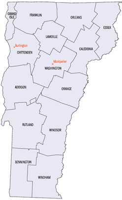
Lista över countyn i Vermont
Detta är en lista över de 14 countyn som finns i delstaten Vermont i USA.[1]
| County | Centralort (county seat) | Etablerat | Folkmängd (2000) | Yta |
|---|---|---|---|---|
| Addison County | Middlebury | 1785 | 35 974 | 2 093 km² |
| Bennington County | Manchester Bennington | 1779 | 36 994 | 1 755 km² |
| Caledonia County | St. Johnsbury | 1796 | 29 702 | 1 703 km² |
| Chittenden County | Burlington | 1787 | 146 571 | 1 605 km² |
| Essex County | Guildhall | 1792 | 6 459 | 1 745 km² |
| Franklin County | City of St. Albans | 1877 | 45 417 | 1 792 km² |
| Grand Isle County | North Hero | 1777 | 6 901 | 504 km² |
| Lamoille County | Hyde Park | 1835 | 23 233 | 1 201 km² |
| Orange County | Chelsea | 1781 | 28 226 | 1 792 km² |
| Orleans County | Newport | 1792 | 26 277 | 1 868 km² |
| Rutland County | Rutland | 1781 | 63 400 | 2 447 km² |
| Washington County | Montpelier | 1777 | 58 039 | 1 801 km² |
| Windham County | Newfane | 1779 | 44 216 | 2 067 km² |
| Windsor County | Woodstock | 1781 | 57 418 | 2 527 km² |
Referenser
- ^ National Association of Counties - Find a county Arkiverad 4 augusti 2010 hämtat från the Wayback Machine.
| ||||||||||
| |||||
Media som används på denna webbplats
Smaller version of Vermont county map (from PD image)


