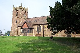
Lilleshall
| Lilleshall | |
| Civil parish | |
(c) Geoff Pick, CC BY-SA 2.0 | |
| Land | |
|---|---|
| Riksdel | England |
| Enhetskommun | Telford and Wrekin |
| Ceremoniellt grevskap | Shropshire |
| Koordinater | 52°44′18″N 2°23′54″V / 52.738237°N 2.398392°V |
| Area | 0,605 km² |
| Folkmängd | 1 028 (2016) |
| Grundad | 2015 |
| Datum | 1 april |
| Tidszon | UTC (UTC+0) |
| - sommartid | BST (UTC+1) |
| Geonames | 2644509 |
Läge i Storbritannien | |
Lilleshall är en by och en civil parish i Telford and Wrekin i Shropshire i England.[1][2] Orten har 1 028 invånare (2016).[3] Byn nämndes i Domedagsboken (Domesday Book) år 1086, och kallades då Linleshelle.[4] Skapad 1 april 2015 (CP).[5]
Referenser
- ”LILLESHALL”. GENUKI. http://www.genuki.org.uk/cgi-bin/maplink?CCC=SAL,GR=SJ732157,PLACE=LILLESHALL. Läst 16 juni 2016.
- ^ ”Ordnance Survey linked data”. Ordnance Survey. http://data.ordnancesurvey.co.uk/doc/7000000000009350. Läst 16 juni 2016.
- ^ ”Lilleshall”. MapIt. https://mapit.mysociety.org/area/145952.html. Läst 16 juni 2016.
- ^ ”Lilleshall”. City Population. https://www.citypopulation.de/php/uk-england-westmidlands.php?cityid=E34004156. Läst 28 december 2017.
- ^ The Domesday Book online. ”Shropshire E-L”. http://domesdaybook.co.uk/shropshire2.html#lilleshall. Läst 16 juni 2016.
- ^ The Borough of Telford & Wrekin (Reorganisation of Community Governance) Order No.2 of 2015
Media som används på denna webbplats
Författare/Upphovsman: Alexrk2, Licens: CC BY-SA 3.0
Location map of the United Kingdom
Shiny red button/marker widget. Used to mark the location of something such as a tourist attraction.
(c) Geoff Pick, CC BY-SA 2.0
St Michael and All Angels parish church, Lilleshall, Shropshire, seen from the south


