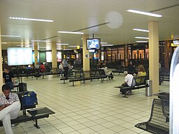
Librevilles internationella flygplats
| Librevilles internationella flygplats | |
| Flygplats | |
Väntsal på flygplatsen. | |
| Land | |
|---|---|
| Provins | Estuaire |
| Höjdläge | 12 m ö.h. |
| Koordinater | 0°27′31″N 9°24′44″Ö / 0.4586°N 9.41228°Ö |
| Tidszon | WAT (UTC+1) |
| Geonames | 6297072 |
Läge i Gabon | |
Librevilles internationella flygplats är en flygplats i Gabons huvudstad Libreville. Den ligger i provinsen Estuaire, i den nordvästra delen av landet, 9 km nordväst om Librevilles centrum. Librevilles internationella flygplats ligger 12 meter över havet.[1] IATA-koden är LBV och ICAO-koden FOOL.[2]
Källor
- ^ ”07AD2-FOOL-VLC” (på franska) (PDF). eAIP ASECNA. Agence pour la sécurité de la navigation aérienne en Afrique et à Madagascar. 27 januari 2022. https://aim.asecna.aero/html/eAIP/cartes/atlas/gabon/Libreville/07AD2-FOOL-VLC.pdf. Läst 8 mars 2022.
- ^ Ranter, Harro; Lujan, Fabian I. (5 november 2013). ”Libreville Airport profile” (på engelska). ASN Aviation Safety Database. Aviation Safety Network. https://aviation-safety.net/database/airport/airport.php?id=LBV. Läst 8 mars 2022.
Externa länkar
 Wikimedia Commons har media som rör Librevilles internationella flygplats.
Media som används på denna webbplats
Shiny red button/marker widget. Used to mark the location of something such as a tourist attraction.
Författare/Upphovsman: Dvermeirre, Licens: CC BY-SA 4.0
Departure lounge (airside) of LBV Libreville International, in the evening.
Författare/Upphovsman: Uwe Dedering, Licens: CC BY-SA 3.0
Relief location map of Gabon.
- Projection: Equirectangular projection, strechted by 100.0%.
- Geographic limits of the map:
- N: 2.5° N
- S: -4.0° N
- W: 8.0° E
- E: 15.0° E
- GMT projection: -JX20.32cd/18.86857142857143cd
- GMT region: -R8.0/-4.0/15.0/2.5r
- GMT region for grdcut: -R8.0/-4.0/15.0/2.5r
- Relief: SRTM30plus.
- Made with Natural Earth. Free vector and raster map data @ naturalearthdata.com.


