Lexington, Tennessee
| Lexington | |
| city | |
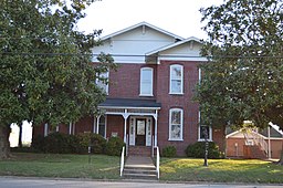
Thompsie Edwards House | |
| Land | |
|---|---|
| Delstat | Tennessee |
| County | Henderson County |
| Höjdläge | 159 m ö.h. |
| Koordinater | 35°39′3″N 88°23′36″V / 35.65083°N 88.39333°V |
| Yta | 30,3 km² (2010) |
| - land | 29,9 km² |
| - vatten | 0,4 km² |
| Folkmängd | 7 956 (2020)[1] |
| Befolkningstäthet | 266 invånare/km² |
| Tidszon | CST (UTC-6) |
| - sommartid | CDT (UTC-5) |
| ZIP-kod | 38351 |
| Riktnummer | 731 |
| FIPS | 4741980 |
| Geonames | 4636463 |
Ortens läge i Tennessee | |
Tennessees läge i USA | |
| Webbplats: lexingtontn.gov | |
Lexington är administrativ huvudort i Henderson County i Tennessee.[2][3][4] Vid 2020 års folkräkning hade Lexington 7 956 invånare.[1]
Källor
- ^ [a b] ”Lexington city, Tennessee 2020 Decennial Census” (på engelska). United States Census Bureau. https://data.census.gov/profile/Lexington_city,_Tennessee?g=1600000US4741980. Läst 15 december 2022.
- ^ Tennessee County Map with County Seat Cities. Geology.com Geoscience News and Information. Läst 18 juli 2017.
- ^ Lexington, TN. Map Quest. Läst 18 juli 2017.
- ^ Profile for Lexington, Tennessee Arkiverad 15 juni 2017 hämtat från the Wayback Machine.. ePodunk. Läst 18 juli 2017.
|
Media som används på denna webbplats
Författare/Upphovsman: Alexrk, Licens: CC BY 3.0
Den här Det karta skapades med GeoTools.
Shiny red button/marker widget. Used to mark the location of something such as a tourist attraction.
Författare/Upphovsman: Huebi, Licens: CC BY 2.0
Map of USA with Tennessee highlighted <large>
Front of the Thompsie Edwards House (now a law office), located at 113 S. Main Street in Lexington, Tennessee, United States. Built in 1894, it is listed on the National Register of Historic Places.


