Lexington, Michigan
| Lexington | |
| village | |
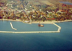
Flygbild över Lexington. | |
| Land | |
|---|---|
| Delstat | Michigan |
| County | Sanilac County |
| Höjdläge | 188 m ö.h. |
| Koordinater | 43°16′7″N 82°32′1″V / 43.26861°N 82.53361°V |
| Yta | 4 km² (2010) |
| - land | 4 km² |
| - vatten | 0 km² |
| Folkmängd | 1 178 (2010) |
| Befolkningstäthet | 295 invånare/km² |
| Tidszon | EST (UTC-5) |
| - sommartid | EDT (UTC-4) |
| ZIP-kod | 48450 |
| Riktnummer | 810 |
| FIPS | 2647280 |
| Geonames | 4999171 |
Ortens läge i Michigan | |
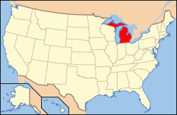
Michigans läge i USA | |
| Webbplats: www.lexingtonmichigan.org | |
Lexington är en ort (village) i Sanilac County i Michigan.[1] Vid 2010 års folkräkning hade Lexington 1 178 invånare.[2]
Källor
- ^ Lexington, MI. Map Quest. Läst 29 juni 2018.
- ^ 2010 Census Population of Lexington, Michigan Arkiverad 29 juni 2018 hämtat från the Wayback Machine.. Census Viewer. Läst 29 juni 2018.
|
Media som används på denna webbplats
Shiny red button/marker widget. Used to mark the location of something such as a tourist attraction.
Författare/Upphovsman: Alexrk2, Licens: CC BY 3.0
Den här Det karta skapades med GeoTools.
Aerial view of Lexington, Michigan, USA. The U.S. Army Corps of Engineers constructed the harbor and breakwater on Lake Huron.
Författare/Upphovsman:
| This media | uploader |
|---|---|
| Original work | en:User:Wapcaplet |
Map of USA with Michigan highlighted


