Leinster
| Den här artikeln behöver källhänvisningar för att kunna verifieras. (2019-10) Åtgärda genom att lägga till pålitliga källor (gärna som fotnoter). Uppgifter utan källhänvisning kan ifrågasättas och tas bort utan att det behöver diskuteras på diskussionssidan. |
| Leinster (Cúige Laighean) | ||
| Lagénîn | ||
| Provins | ||
| ||
| Land | ||
|---|---|---|
| Koordinater | 53°10′00″N 7°01′16″V / 53.16667°N 7.02121°V | |
| Tidszon | UTC (UTC+0) | |
| - sommartid | BST (UTC+1) | |
| ISO 3166-2-kod | IE-L | |
| Geonames | 7521314 | |
Läge i Irland | ||
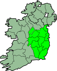
(c) Morwen, CC BY-SA 3.0 Karta över Irland med Leinster markerat | ||
Leinster (iriska: Laighin) är en av Irlands fyra historiska provinser. De övriga är Munster, Ulster och Connacht.
Leinster är den östligaste provinsen. Den består av grevskapen Carlow, Dublin, Kildare, Kilkenny, Laois, Longford, Louth, Meath, Offaly, Westmeath, Wexford och Wicklow.
| ||||||||||||||||
Media som används på denna webbplats
Författare/Upphovsman: Tkgd2007, Licens: CC BY-SA 3.0
A new incarnation of Image:Question_book-3.svg, which was uploaded by user AzaToth. This file is available on the English version of Wikipedia under the filename en:Image:Question book-new.svg
Författare/Upphovsman: Nilfanion, Licens: CC BY-SA 3.0
Relief location map of Ireland
Equirectangular map projection on WGS 84 datum, with N/S stretched 170%
Geographic limits:
- West: 11.0° W
- East: 5.0° W
- North: 55.6° N
- South: 51.2° N
Shiny red button/marker widget. Used to mark the location of something such as a tourist attraction.
Författare/Upphovsman:
- Island_of_Ireland_location_map.svg: Rannpháirtí anaithnid
- derivative work: NikNaks (talk)
Locator map of Leinster.
Författare/Upphovsman: Joe King,Inkey, Licens: CC BY-SA 3.0
The J. B. Malone memorial overlooking Lough Tay in the Wicklow Mountains National Park on the Wicklow Way walking trail, County Wicklow, Ireland


