Lawrence County, Alabama
| Lawrence County | |
| County | |
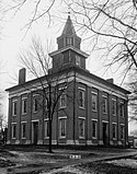
Gamla domstolsbyggnaden i Lawrence County. | |
| Land | |
|---|---|
| Delstat | |
| Huvudort | Moulton |
| Area | 1 858 km² (2010)[1] |
| - land | 1 789 km² (96%) |
| - vatten | 68,7 km² (4%) |
| Folkmängd | 34 339 (2010)[2] |
| Befolkningstäthet | 19 invånare/km² |
| Grundat | 1818 |
| Tidszon | CST (UTC-6) |
| - sommartid | CDT (UTC-5) |
| FIPS-kod | 01079 |
| Geonames | 4071959 |
Läge i delstaten Alabama. | |
Delstatens läge i USA. | |
Lawrence County är ett administrativt område i delstaten Alabama, USA, med 34 339 invånare. Den administrativa huvudorten (county seat) är Moulton.
Geografi
Enligt United States Census Bureau så har countyt en total area på 1 860 km². 1 795 km² av den arean är land och 65 km² är vatten.
Angränsande countyn
- Limestone County - nordöst
- Morgan County - öst
- Cullman County - sydöst
- Winston County - syd
- Franklin County - väst
- Colbert County - väst
- Lauderdale County - nordväst
Referenser
- ^ ”2010 Census U.S. Gazetteer Files for Counties”. U.S. Census Bureau. Arkiverad från originalet den 5 juli 2012. https://www.webcitation.org/68vYLbou5?url=http://www.census.gov/geo/www/gazetteer/files/Gaz_counties_national.txt. Läst 5 juli 2012.
- ^ ”State & County QuickFacts, Lawrence County, Alabama” (på engelska). U.S. Census Bureau. Arkiverad från originalet den 13 juli 2011. https://www.webcitation.org/609AKqpOM?url=http://quickfacts.census.gov/qfd/states/01/01079.html. Läst 6 juli 2011.
| ||||||||||
|
Media som används på denna webbplats
Författare/Upphovsman: Huebi, Licens: CC BY 2.0
Map of USA with Alabama highlighted
Lawrence County Courthouse, Courthouse Square bounded by Main Street, Lawrence Street, Market Street & Court Street, Moulton (Lawrence County, Alabama)
cropped
This was demolished about 1935 and is not the current courthouse
 |
This file comes from the Historic American Buildings Survey (HABS), Historic American Engineering Record (HAER) or Historic American Landscapes Survey (HALS). These are programs of the National Park Service established for the purpose of documenting historic places. Records consist of measured drawings, archival photographs, and written reports.
|
| This image or media file contains material based on a work of a National Park Service employee, created as part of that person's official duties. As a work of the U.S. federal government, such work is in the public domain in the United States. See the NPS website and NPS copyright policy for more information. |
 |
This is a locator map showing Lawrence County in Alabama. For more information, see Commons:United States county locator maps.


