Laois
| Den här artikeln behöver källhänvisningar för att kunna verifieras. (2024-12) Åtgärda genom att lägga till pålitliga källor (gärna som fotnoter). Uppgifter utan källhänvisning kan ifrågasättas och tas bort utan att det behöver diskuteras på diskussionssidan. |
| County Laois | ||
| Contae Laoise | ||
| Grevskap | ||
| ||
| Land | ||
|---|---|---|
| Provins | Leinster | |
| Huvudort | Portlaoise | |
| Area | 1 719 km² | |
| Folkmängd | 58 774 (2002) | |
| Befolkningstäthet | 34 invånare/km² | |
| Tidszon | WET (UTC±0) | |
| - sommartid | WEST (UTC+1) | |
| Geonames | 2963031 | |
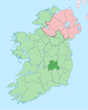
Karta med County Laois markerat | ||
Laois (ibland även stavat Laoighis eller Leix, iriska: Laois) är ett grevskap på Irland. Detta är det enda grevskapet som inte gränsar till något annat grevskap som i sin tur gränsar med havet, vilket alla andra grevskap på något sätt gör. Huvudort är Portlaoise.
Grevskapet upprättades av drottning Maria I av England år 1556 under namnet Queen's County.
Städer och samhällen
- Abbeyleix, Aghaboe
- Ballaghmore, Ballickmoyler, Ballinakill, Ballyfin, Ballylynan, Ballyroan, Borris-in-ossory
- Clonenagh
- Donaghmore, Durrow
- Emo
- Mountmellick, Mountrath
- Portarlington, Portlaoise
- Rathdowney, Rosenallis
- Stradbally
- Timahoe
- Vicarstown
| ||||||||||||||||
Media som används på denna webbplats
Författare/Upphovsman: Tkgd2007, Licens: CC BY-SA 3.0
A new incarnation of Image:Question_book-3.svg, which was uploaded by user AzaToth. This file is available on the English version of Wikipedia under the filename en:Image:Question book-new.svg
Författare/Upphovsman: Kanchelskis, free hand work., Licens: CC BY-SA 3.0
County Laois crest.
Toponomastica: L'attuale nome Laois (da pronunciare nella nostra lingua lish) è il nome gaelico di quella che una volta era la Queen's county ("contea della regina"), e significa letteralmente "chiesa nei pressi della quercia".
Da notare che anche le forme anglicizzate Laoighis e Leix sono corrette.
Araldica civica
Lo stemma del Laois è uno scudo dorato con un nastro contenente vari elementi distintivi.
- la V rossa capovolta (chevronels): rappresenta la catena montuosa delle Slieve Bloom Mountains e la Rock of Dunamaise, mentre i simboli bianchi in essa contenuti rappresentano le 7 tribù antiche locali principali.
- le due sfere ondulate (fountains): rappresentano i due fiumi principali della contea, il Nore e il Barrow e i due colori tradizionali e sportivi della contea (bianco-blu)
- il leone: l'animale su sfondo dorato era l'emblema degli antichi King of Laois, gli Ó Mordha.
Il nastro invece riporta il motto in gaelico "L bÁirt leis an bpobal" che significa "Insieme con il Popolo".
Bibliografia:
Författare/Upphovsman:
- Island_of_Ireland_location_map.svg: *Ireland_location_map.svg: NordNordWest
- Northern_Ireland_location_map.svg: NordNordWest
- Northern_Ireland_-_Counties.png: Maximilian Dörrbecker (Chumwa)
- derivative work: Rannpháirtí anaithnid (talk)
- derivative work: Mabuska (talk)
The island of Ireland, showing international border between Ireland and Northern Ireland, traditional provinces, traditional counties, and local authority areas in Ireland and Northern Ireland.


