Lakkíon
| Lakkíon | |
| Portolago, Temania, Port Laki, Lakkí | |
| Ort | |
Strandpromenaden i Lakkion | |
| Officiellt namn: Λακκίον | |
| Land | |
|---|---|
| Region | Sydegeiska öarna |
| Prefektur | Nomós Dodekanísou |
| Höjdläge | 6 m ö.h. |
| Koordinater | 37°08′00″N 26°51′00″Ö / 37.13333°N 26.85°Ö |
| Folkmängd | 1 956 (2012-01-18)[1] |
| Tidszon | EET (UTC+2) |
| - sommartid | EEST (UTC+3) |
| Geonames | 258672 |
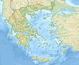
Läge i Grekland | |
Lakkíon, under den italienska ockupationen Portolago, är en tätort vid kusten på Leros i Grekland.[1]
Källor
Noter
- ^ [a b] Lakkíon hos Geonames.org (cc-by); post uppdaterad 2012-01-18; databasdump nerladdad 2015-05-23
Media som används på denna webbplats
Shiny red button/marker widget. Used to mark the location of something such as a tourist attraction.
Författare/Upphovsman:
- Greece_location_map.svg: Lencer / derivative work: Uwe Dedering (talk)
Location map of Greece
Lakki seafront. Lakki was the former Portolago, the 1930s new model town, built by the Italian authorities. It is one of the best examples of Italian Rationalist architecture.


