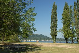
Lake Sammamish State Park
| Lake Sammamish State Park | |
| Nationalpark | |
| Land | |
|---|---|
| Läge | Issaquah, Washington |
| - koordinater | 47°33′36″N 122°03′36″V / 47.56000°N 122.06000°V |
| Area | 205 hektar |
| Inrättad | 1950 |
| Geonames | 5800306 |
Lake Sammamish State Parks läge i USA. | |
| Webbplats: Lake Sammamish State Park | |
Lake Sammamish State Park är en park vid Lake Sammamishs södra ände i King County i delstaten Washington i nordvästra USA. Parken inrättades 1950.
Seriemördaren Ted Bundy kidnappade två kvinnor vid Lake Sammamish State Park den 14 juli 1974: först 23-åriga Janice Ott[1] och fyra timmar senare 18-åriga Denise Naslund.[2] De båda kvinnornas kvarlevor påträffades i Issaquah två månader senare.[3]
Källor
Noter
- ^ Rule 2000, s. 83–84.
- ^ Rule 2000, s. 84–85.
- ^ ”Bones are remains of 2 missing women”. The Daily Chronicle. 11 september 1974. https://www.newspapers.com/clip/31113871/remains-of-janice-anne-ott-and-denise/. Läst 30 september 2020.
Webbkällor
- ”Feature Detail Report for: Lake Sammamish State Park”. Geographic Names Information System. United States Geological Survey. https://geonames.usgs.gov/apex/f?p=gnispq:3:::NO::P3_FID:1511547. Läst 30 september 2020.
Tryckta källor
- Rule, Ann (2000) (på engelska). The Stranger Beside Me: Ted Bundy: The Classic Case of Serial Murder. New York: W.W. Norton Company. ISBN 0-393-05029-7
Externa länkar
 Wikimedia Commons har media som rör Lake Sammamish State Park.
Media som används på denna webbplats
Shiny red button/marker widget. Used to mark the location of something such as a tourist attraction.
Författare/Upphovsman: TUBS
Location map of the USA (Hawaii and Alaska shown in sidemaps).
Main map: EquiDistantConicProjection : Central parallel :
* N: 37.0° N
Central meridian :
* E: 96.0° W
Standard parallels:
* 1: 32.0° N
* 2: 42.0° N
Made with Natural Earth. Free vector and raster map data @ naturalearthdata.com.
Formulas for x and y:
x = 50.0 + 124.03149777329222 * ((1.9694462586094064-({{{2}}}* pi / 180))
      * sin(0.6010514667026994 * ({{{3}}} + 96) * pi / 180))
y = 50.0 + 1.6155950752393982 * 124.03149777329222 * 0.02613325650382181
      - 1.6155950752393982  * 124.03149777329222 *
     (1.3236744353715044  - (1.9694462586094064-({{{2}}}* pi / 180))
      * cos(0.6010514667026994 * ({{{3}}} + 96) * pi / 180))
Hawaii side map: Equirectangular projection, N/S stretching 107 %. Geographic limits of the map:
- N: 22.4° N
- S: 18.7° N
- W: 160.7° W
- E: 154.6° W
Alaska side map: Equirectangular projection, N/S stretching 210.0 %. Geographic limits of the map:
- N: 72.0° N
- S: 51.0° N
- W: 172.0° E
- E: 129.0° W
Författare/Upphovsman: Mggkitsap, Licens: CC BY 3.0
Lake Sammamish State Park, Washington, USA located at the southeast end of the lake.


