Lake Louise, Alaska
| Lake Louise | |
| CDP | |
Bebyggd ö i sjön med samma namn som orten | |
| Land | |
|---|---|
| Delstat | |
| Borough | Matanuska-Susitna Borough |
| Höjdläge | 746 m ö.h. |
| Koordinater | 62°17′4″N 146°33′25″V / 62.28444°N 146.55694°V |
| Area | 193,2 km² (2010)[1] |
| - land | 126,85 km² (2010) |
| - vatten | 66,35 km² (2010) |
| Folkmängd | 15 (2020)[2] |
| Befolkningstäthet | 0 invånare/km² |
| Tidszon | AST (UTC-9) |
| - sommartid | ADT (UTC-8) |
| ZIP-kod | 99588 |
| Riktnummer | 907 |
| GNIS-kod | 1865556 |
| Geonames | 5867104 |
Lake Louise i Matanuska-Susitna Borough och Alaska | |
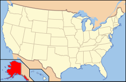
Alaskas läge i USA | |
| Wikimedia Commons: Lake Louise, Alaska | |
| Redigera Wikidata | |
Lake Louise (ahtna: Sasnuu’ Bene’) är en plats (CDP) i Matanuska-Susitna Borough i delstaten Alaska i USA. Platsen hade 46 invånare, på en yta av 193,20 km² (2010).[3]
Referenser
- ^ United States Census Bureau, 2010 U.S. Gazetteer Files, United States Census Bureau, 2010, läst: 9 juli 2020.[källa från Wikidata]
- ^ United States Census Bureau (red.), USA:s folkräkning 2020, läs online, läst: 1 januari 2022.[källa från Wikidata]
- ^ ”Gazetteer Files – 2010” (på amerikansk engelska). The United States Census Bureau. https://www.census.gov/geographies/reference-files/time-series/geo/gazetteer-files.2010.html. Läst 9 augusti 2021.
Externa länkar
 Wikimedia Commons har media som rör Lake Louise.
Media som används på denna webbplats
Författare/Upphovsman: Huebi, Licens: CC BY 2.0
Map of USA with Alaska highlighted
Författare/Upphovsman: Rcsprinter123, Licens: CC BY 3.0
Map showing the location this CDP within Matanuska-Susitna Borough, Alaska. Data source: 2010 U.S. census
(c) Beeblebrox på engelska Wikipedia, CC BY-SA 3.0
Lake Louise road, with the lake in the distance
(c) Beeblebrox på engelska Wikipedia, CC BY-SA 3.0
an island with a house on it, Lake Louise


