Laives, Sydtyrolen
| Laives | |||
| Leifers | |||
| Kommun | |||
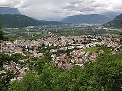
Vy över Laives | |||
| |||
| Officiellt namn: Comune di Laives Gemeinde Leifers | |||
| Land | |||
|---|---|---|---|
| Region | Trentino-Sydtyrolen | ||
| Provins | Sydtyrolen (BZ) | ||
| Höjdläge | 255 m ö.h. | ||
| Koordinater | 46°25′22″N 11°20′5″Ö / 46.42278°N 11.33472°Ö | ||
| Yta | 24,11 km²[1] | ||
| Folkmängd | 18 468 (2024-01-01)[2] | ||
| Befolkningstäthet | 766 invånare/km² | ||
| Tidszon | CET (UTC+1) | ||
| - sommartid | CEST (UTC+2) | ||
| Postnummer | 39055 | ||
| Riktnummer | 0471 | ||
| ISTAT-kod | 021040 | ||
| Geonames | 6535956 | ||
| Skyddspatron | Den helige Antonius | ||
| OSM-karta | 47187 | ||
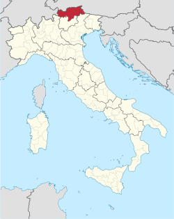
Läge i Italien | |||
Kommunens läge i provinsen Sydtyrolen | |||
| Webbplats: www.comune.laives.bz.it | |||
Laives (italienskt uttal: [ˈlaives], tyska: Leifers [ˈlaɪfɐs]) är en stad och kommun i provinsen Sydtyrolen i regionen Trentino-Sydtyrolen i norra Italien. Den är belägen cirka 8 kilometer söder om Bolzano. Kommunen har 18 468 invånare (2024),[2] på en yta av 24,11 km².[1] Enligt 2024 års folkräkning talar 74,47 % av befolkningen italienska, 25,16 % tyska och 0,36 % ladinska som modersmål.[3]
Orter
Orter (località) i kommunen Laives med fler än 20 invånare (inom parentes invånarantal 2021):[4]
- Laives/Leifers (11 111)
- Pineta/Steinmannwald (2 263)
- San Giacomo/St. Jakob (3 694)
Referenser
- ^ [a b] ”Caratteristiche del territorio – Superfici territoriali”. esploradati.istat.it. Istituto Nazionale di Statistica (ISTAT). https://esploradati.istat.it/databrowser/#/it/dw/categories/IT1,Z0930TER,1.0/DCCV_CARGEOMOR_ST_COM/IT1,DCCV_CARGEOMOR_ST_COM,1.0. Läst 25 januari 2025.
- ^ [a b] ”Popolazione e famiglie – Popolazione residente al 1° gennaio”. esploradati.istat.it. Istituto Nazionale di Statistica (ISTAT). https://esploradati.istat.it/databrowser/#/it/dw/categories/IT1,POP,1.0/POP_POPULATION/DCIS_POPRES1. Läst 25 januari 2025.
- ^ ”Ergebnisse Sprachgruppenzählung 2024 / Risultati Censimento linguistico 2024” (på tyska & italienska) (
 PDF). astat.provinz.bz.it. Landesinstitut für Statistik (ASTAT). 6 december 2024. https://astat.provinz.bz.it/de/aktuelles-publikationen-info.asp?news_action=300&news_image_id=1160209. Läst 26 januari 2025.
 - ^ ”Basi territoriali e variabili censuarie” (på italienska). www.istat.it. Istituto Nazionale di Statistica (ISTAT). 26 juli 2024. https://www.istat.it/notizia/basi-territoriali-e-variabili-censuarie/. Läst 26 januari 2025.
Externa länkar
 Wikimedia Commons har media som rör Laives.
- Officiell webbplats
Media som används på denna webbplats
Shiny red button/marker widget. Used to mark the location of something such as a tourist attraction.
Författare/Upphovsman: boboseiptu, Licens: CC BY-SA 4.0
Laives (in basso) e la valle dell'Adige fino a Bolzano
Författare/Upphovsman: Original: NordNordWest, from Italy Bolzano-Bozen location map.svg:
Härlett verk: Krepideia, Licens: CC BY-SA 3.0
Map of the municipality (comune) of Laives (Italy) (province of Bolzano, region Trentino-South Tyrol, Italien)
Författare/Upphovsman: TUBS
Location of the province South Tyrol in Italy.
Författare/Upphovsman: TUBS
Location of province XY (see filename) in Italy.
Författare/Upphovsman: Den här vektoriserade bilden innehåller hämtade eller omarbetade delar av den här filen:, Licens: CC BY-SA 4.0
Gonfalone di Laives, Italia


