La Louptière-Thénard
| La Louptière-Thénard | |
| Kommun | |
 | |
| Land | |
|---|---|
| Region | Grand Est |
| Departement | |
| Arrondissement | Nogent-sur-Seine |
| Kanton | Nogent-sur-Seine |
| Koordinater | 48°23′N 3°26′Ö / 48.383°N 3.433°Ö |
| Yta | 13,68 km²[1] |
| Folkmängd | 300 ()[2] |
| Befolkningstäthet | 22 invånare/km² |
| Tidszon | CET (UTC+1) |
| - sommartid | CEST (UTC+2) |
| Postnummer | 10400 |
| INSEE | 10208 |
| Geonames | 6455510 |
| OSM-karta | 1774046 |
 Kommunens läge i regionen Grand Est i Frankrike. | |

La Louptière-Thénard är en kommun i departementet Aube i regionen Grand Est (tidigare regionen Champagne-Ardenne) i nordöstra Frankrike. Kommunen ligger i kantonen Nogent-sur-Seine som ligger i arrondissementet Nogent-sur-Seine. År 2022 hade La Louptière-Thénard 300 invånare. Namnledet "Thénard" påminner om ortens store son Louis Jacques Thénard.
Befolkningsutveckling
Antalet invånare i kommunen La Louptière-Thénard
Referens: INSEE[3]
Galleri
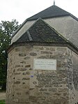
 Kyrkan
Se även
Källor
- ^ Répertoire géographique des communes, Institut national de l'information géographique et forestière, läst: 26 oktober 2015.[källa från Wikidata]
- ^ Populations légales 2022, Institut National de la Statistique et des Études Économiques, 19 december 2024.[källa från Wikidata]
- ^ Chiffres clés - Évolution et structure de la population Arkiverad 5 juli 2012 hämtat från the Wayback Machine.
Media som används på denna webbplats

Författare/Upphovsman: Eric Gaba (Sting - fr:Sting), Licens: CC BY-SA 4.0
Blank physical map of metropolitan France for geo-location purpose.
Scale : 1:14 816 000 (accuracy : about 3,7 km) for the bathymetry. More maps of France, view → Commons Atlas of France.

Shiny red button/marker widget. Used to mark the location of something such as a tourist attraction.
.jpg)
Författare/Upphovsman: Hg marigny, Licens: CC BY-SA 3.0
Eglise de la Louptière-Thénard
Författare/Upphovsman: Hg marigny, Licens: CC BY-SA 3.0
Maison natale de Louis Jacques Thénard
Författare/Upphovsman:
|
Map data (c) OpenStreetMap contributors, CC-BY-SA _French_municipality_map.svg) • Shape files infrastructure: railway, highways, water: all originally by OpenStreetMap contributors. Status december 2011 *note: shown commune boundaries are from OSM dump May 2012; at that time about 90% complete |
Map commune FR insee code 10208.png

.jpg)
Författare/Upphovsman: Hg marigny, Licens: CC BY-SA 3.0
La Louptière-Thénard
.jpg)
Författare/Upphovsman: Hg marigny, Licens: CC BY-SA 3.0
Maison natale du Baron Thénard