La Grave
| La Grave | ||
| Kommun | ||
 | ||
| ||
| Land | ||
|---|---|---|
| Region | ||
| Departement | ||
| Arrondissement | Briançon | |
| Kanton | La Grave | |
| Koordinater | 45°3′N 6°18′Ö / 45.050°N 6.300°Ö | |
| Yta | 126,91 km²[1] | |
| Folkmängd | 477 ()[2] | |
| Befolkningstäthet | 4 invånare/km² | |
| Tidszon | CET (UTC+1) | |
| - sommartid | CEST (UTC+2) | |
| Postnummer | 05320 | |
| INSEE | 05063 | |
| Geonames | 6618135 | |
| OSM-karta | 114007 | |
 Kommunens läge i regionen Provence-Alpes-Côte d'Azur i Frankrike | ||
| Webbplats: https://lagrave-lameije.fr | ||

La Grave är en kommun i departementet Hautes-Alpes i regionen Provence-Alpes-Côte d'Azur i nordöstra Frankrike. Kommunen ligger i kantonen La Grave som tillhör arrondissementet Briançon. År 2021 hade La Grave 477 invånare.
La Grave ligger i de franska alperna och är känd för sin fina off-pistskidåkning.
Befolkningsutveckling
Antalet invånare i kommunen La Grave
 Referens: INSEE[3] |
Galleri
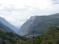 La Graves läge i botten på La Gravedalen
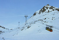 Skidanläggningen
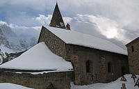 Kyrkan
 Glaciären Girose
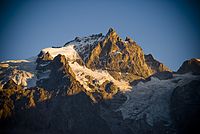 Nordsidan av La Gravedalen
Se även
Källor
- ^ Répertoire géographique des communes, Institut national de l'information géographique et forestière, läst: 26 oktober 2015.[källa från Wikidata]
- ^ Populations légales 2021, Institut National de la Statistique et des Études Économiques, 28 december 2023.[källa från Wikidata]
- ^ Chiffres clés - Évolution et structure de la population hämtat från the Wayback Machine (arkiverat 4 maj 2012).
Media som används på denna webbplats

Författare/Upphovsman: Eric Gaba (Sting - fr:Sting), Licens: CC BY-SA 4.0
Blank physical map of metropolitan France for geo-location purpose.
Scale : 1:14 816 000 (accuracy : about 3,7 km) for the bathymetry. More maps of France, view → Commons Atlas of France.

Shiny red button/marker widget. Used to mark the location of something such as a tourist attraction.

parti, en 1 de gueules à la croix cléchée, vidée et pommetée de douze pièces d’or et en 2 d’or au dauphin d’azur crêté, barbé, loré, peautré et oreillé de gueules; au chef d’azur semé de fleurs de lys d’or

Författare/Upphovsman: Gerdami, Belgium, Licens: CC BY-SA 3.0
La Grave - Glacier de la Girose

Författare/Upphovsman: da'ba from Oslo, Licens: CC BY 2.0
View of the North Face from Les Terasses, La Grave valley.

Kirche von La Grave

Författare/Upphovsman: Michiel1972, Licens: CC BY-SA 3.0
Population - Municipality code 05063.svg
Population Census 1962-2008Författare/Upphovsman:
|
Map data (c) OpenStreetMap contributors, CC-BY-SA _French_municipality_map.svg) • Shape files infrastructure: railway, highways, water: all originally by OpenStreetMap contributors. Status december 2011 *note: shown commune boundaries are from OSM dump May 2012; at that time about 90% complete |
Map commune FR insee code 05063.png

Författare/Upphovsman: Éclusette, Licens: CC BY 3.0
Massif de la Meije, Hautes-Alpes, France.


Författare/Upphovsman: Rémih, Licens: CC BY-SA 3.0
La Grave (down), les Terrasses (up) and Romanche valley seen from Villar d'Arêne, Oisan mountains, Hautes-Alpes, France