Lærdals kommun
| Lærdals kommun | |||
| Lærdal kommune | |||
| Kommun | |||
| |||
| Land | |||
|---|---|---|---|
| Fylke | Vestland fylke | ||
| Koordinater | 61°3′4″N 7°35′52″Ö / 61.05111°N 7.59778°Ö | ||
| Centralort | Lærdalsøyri | ||
| Högsta punkt | Høgeloft[1] | ||
| - höjdläge | 1 921,206 m ö.h. | ||
| - koordinater | 61°3′14″N 8°12′49″Ö / 61.05389°N 8.21361°Ö | ||
| Area | 1 406,31 km² (2020)[6] | ||
| - land | 1 275,86 km² (2020) | ||
| - vatten | 130,46 km² | ||
| Folkmängd | 2 129 (2023)[7] | ||
| Befolkningstäthet | 2 invånare/km² | ||
| Politik | |||
| - Kommunstyrelsens ordförande | Audun Mo (2019–) (Ap)[5] | ||
| Tidszon | CET (UTC+1) | ||
| - sommartid | CEST (UTC+2) | ||
| Kommunkod | 4642 (2020–) 1422 (–2019) | ||
| Geonames | 3148572 | ||
| Målform | nynorska | ||
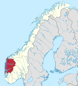
 Lærdals kommun i Vestland fylke. | |||
(c) Karte: NordNordWest, Lizenz: Creative Commons by-sa-3.0 de Vestland fylke i Norge. | |||
| Wikimedia Commons: Lærdal | |||
| Webbplats: https://www.laerdal.kommune.no/ | |||
| Redigera Wikidata | |||
Lærdals kommun (norska: Lærdal kommune) är en kommun i landskapet Sogn i Vestland fylke i västra Norge. Kommunens centralort är tätorten Lærdalsøyri. I byn Borgund finns Borgunds stavkyrka.
Tidigare har kommunen tillhört dåvarande Sogn og Fjordane fylke.
Administrativ historik
Lærdals kommun upprättades den 1 januari 1838 (som Leirdal formannskapsdistrikt) när Formannskapslovene från 1837 trädde i kraft. Kommunen omfattade då större delen av nuvarande Lærdals kommun samt hela nuvarande Årdals kommun.
1863 och 1864 bröts Årdals kommun respektive Borgunds kommun ut ur kommunen. Den återstående delen omfattade i stora drag den västra delen av nuvarande Lærdals kommun och hade 2 777 invånare efter de båda delningarna.[8]
Den 1 januari 1964 gick Borgunds kommun samt en del av Årdals kommun (gårdarna Muggeteigen med husmansplatserna Luggenes och Bergmål på Aspevikstranda) upp i Lærdals kommun. Kommunen ökade då från 1 755 invånare före sammanslagningen till 2 258 invånare efter.[8]
Den 1 januari 1992 överfördes ett bebott område (grundkrets 0205 Frønning med 32 invånare) från Leikangers kommun till Lærdals kommun.[8]
Tätorter
I Lærdals kommun finns en tätort:[9]
- Lærdalsøyri (centralort)
Socknar
Inom Norska kyrkan motsvaras Lærdals kommun av Lærdals socken i Sogns prosteri i Bjørgvins stift.[10]
Bilder
- Fodnes vid Sognefjorden.
- Älven Lærdalselvi i Lærdalen.
Källor
- ^ läs online, kartverket.no , läst: 12 mars 2021.[källa från Wikidata]
- ^ [a b] Dag Juvkam, Historisk oversikt over endringer i kommune- og fylkesinndelingen, Statistisk sentralbyrå, maj 1999, s. 53, ISBN 82-537-4684-9, läs online.[källa från Wikidata]
- ^ Dag Juvkam, Historisk oversikt over endringer i kommune- og fylkesinndelingen, Statistisk sentralbyrå, maj 1999, s. 55, ISBN 82-537-4684-9, läs online.[källa från Wikidata]
- ^ Dag Juvkam, Historisk oversikt over endringer i kommune- og fylkesinndelingen, Statistisk sentralbyrå, maj 1999, s. 56, ISBN 82-537-4684-9, läs online.[källa från Wikidata]
- ^ läs online, www.laerdal.kommune.no , läst: 12 mars 2021.[källa från Wikidata]
- ^ Statens kartverk, Arealstatistikk for Norge 2020, Statens kartverk, 20 december 2019, läs online.[källa från Wikidata]
- ^ 07459: Alders- og kjønnsfordeling i kommuner, fylker og hele landets befolkning (K) 1986 - 2023 (på norskt bokmål), Statistisk sentralbyrå, 21 februari 2023, läs online.[källa från Wikidata]
- ^ [a b c] ”Historisk oversikt over endringer i kommune- og fylkesinndelingen” (PDF). Statistisk sentralbyrå. Maj 1999. https://www.ssb.no/a/publikasjoner/pdf/rapp_9913/rapp_9913.pdf.
- ^ ”Tettsteders befolkning og areal”. Statistisk sentralbyrå. 12 december 2023. https://www.ssb.no/befolkning/folketall/statistikk/tettsteders-befolkning-og-areal.
- ^ Store norske leksikon
Externa länkar
- Officiell webbplats
 Wikimedia Commons har media som rör Lærdals kommun.
| |||||||
| ||||||||||
Media som används på denna webbplats
Författare/Upphovsman: Gutten på Hemsen, Licens: CC0
Flag of Norway with colors from the previous version on Commons. This file is used to discuss the colors of the Norwegian flag.
(c) Karte: NordNordWest, Lizenz: Creative Commons by-sa-3.0 de
Location of county Vestland in Norway (2024)
Författare/Upphovsman: Jay1279, Licens: CC0
Map of Lærdal municipality in Vestland county, Norway
Författare/Upphovsman: Anna Anichkova, Licens: CC BY-SA 3.0
i databasen för Direktoratet för kulturminnesförvaltning.
Coat of arms for Vestland county, Norway
Författare/Upphovsman: Krg, Licens: CC BY-SA 4.0
Valley Lærdal by Jutlamannen
Coat of arms for Sogn og Fjordane county (fylke), Norway.The coat of arms were granted on 23 September 1983. The arms show the geographical layout of the county: three large fjords protruding into the land. The three fjords are the Nordfjord, Sunnfjord and Sognefjord. As nearly all villages and towns are situated on one of these fjords and the name of the county is based on the fjords.
Coat of arms for the Norwegian municipality of Lærdal.
Författare/Upphovsman: Foto: Frode Inge Helland. 2006.05.14, Licens: CC BY 2.5
Laerdalsoeyri, Sognefjord. 1700-houses
Flag of Lærdal municipality


