Korolev (Marskrater)
| Korolev | |
 Korolev fotograferat av Mars Express i december 2018 | |
| Himlakropp | Mars |
|---|---|
| Koordinater | 72°46′N 164°35′Ö / 72.77°N 164.58°Ö |
| Diameter | 81.37 km |
| Uppkallad efter | Sergej Koroljov[1] |
Korolev är en isfylld nedslagskrater på planeten Mars, på 73° norra latituden och 165° östra longituden. Den är 81,4 kilometer i diameter och innehåller ungefär 2 200 kubikkilometer av vattenis, ungefär lika mycket som det finns i Stora Björnsjön i norra Kanada.[2] Kratern är uppkallad efter Sergej Koroljov (1907–1966), chefsingenjören i Sovjets raketprogram under rymdkapplöpningen på 1950- och 1960-talet.
Allmänt
Mars Korolevkrater ligger på Planum Boreum, den norra polarslätten som omger den norra polarisen, nära Olympia Undae. Kraterkanten reser sig cirka 2 kilometer över den omgivande slätten. Kraterns botten är c:a 2 kilometer nedanför kanten och är täckt av ett c:a 1,8 kilometer permanent islager upp till 60 kilometer i diameter.
Isformation
Isen är permanent tack vare att kratern bildar en naturlig köldfälla. Den tunna Marsluften ovanför kratern är kallare än luften utanför kratern, och eftersom den kalla luften är tyngre sjunker den och bildar ett skyddande lager vilket hindrar den att smälta eller avdunsta.[3]
- Plan vy av Korolevkratern från ESA:s Mars Express
- Karta av Mare Boreum med stora kratrar och formationer utmärkta
Se även
Källor
- ^ ”Korolev on Mars” (på engelska). International Astronomical Union. 1 oktober 2006. https://planetarynames.wr.usgs.gov/Feature/3091. Läst 10 januari 2023.
- ^ ”A winter wonderland in red and white – Korolev Crater on Mars”. German Aerospace Center (DLR). 21 december 2018. Arkiverad från originalet den 13 maj 2020. https://web.archive.org/web/20200513090947/https://www.dlr.de/EN/Service/about-relaunch/explanation.html?cms_url=https%3A%2F%2Fwww.dlr.de%2Fdlr%2Fen%2Fdesktopdefault.aspx%2Ftabid-10081%2F151_read-31614%2F#/gallery/33106.
- ^ ”Mars Express beams back images of ice-filled Korolev crater” (på engelska). The Guardian. 21 december 2018. https://www.theguardian.com/science/2018/dec/21/mars-express-beams-back-images-of-ice-filled-korolev-crater.
| ||||||||||||||||||||||||||||||||||||||||||||||||||||||||
Media som används på denna webbplats
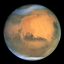
NASA's Hubble Space Telescope took the picture of Mars on June 26, 2001, when Mars was approximately 68 million kilometers (43 million miles) from Earth — the closest Mars has ever been to Earth since 1988. Hubble can see details as small as 16 kilometers (10 miles) across. The colors have been carefully balanced to give a realistic view of Mars' hues as they might appear through a telescope. Especially striking is the large amount of seasonal dust storm activity seen in this image. One large storm system is churning high above the northern polar cap (top of image), and a smaller dust storm cloud can be seen nearby. Another large dust storm is spilling out of the giant Hellas impact basin in the Southern Hemisphere (lower right).
Författare/Upphovsman: ESA/DLR/FU Berlin, Licens: CC BY-SA 3.0
This image from ESA’s Mars Express shows Korolev crater, an 82-kilometre-across feature found in the northern lowlands of Mars.
This plan mosaic comprises five different observational strips that have been combined to form a single image, gathered over orbits 18042 (captured on 4 April 2018), 5726, 5692, 5654, and 1412. It covers a region centred at 165° E, 73° N, and has aresolution of approximately 21 metres per pixel.
This image was created using data from the nadir and colour channels of the High Resolution Stereo Camera (HRSC). The nadir channel is aligned perpendicular to the surface of Mars, as if looking straight down at the surface.Map of Mare Boreum Mars quadrangle. The small, colored rectangles represent image footprints for the narrow angle camera on the Mars Global Surveyor. Some are about 1 mile wide, the otheers are about 2 miles wide.
Författare/Upphovsman: ESA/DLR/FU Berlin, Licens: CC BY-SA 3.0 igo
This image from ESA’s Mars Express shows Korolev crater, an 82-kilometre-across feature found in the northern lowlands of Mars.
This oblique perspective view was generated using a digital terrain model and Mars Express data gathered over orbits 18042 (captured on 4 April 2018), 5726, 5692, 5654, and 1412. The crater itself is centred at 165° E, 73° N on the martian surface. The image has a resolution of roughly 21 metres per pixel.
This image was created using data from the nadir and colour channels of the High Resolution Stereo Camera (HRSC). The nadir channel is aligned perpendicular to the surface of Mars, as if looking straight down at the surface.


