Koreabukten
| Koreabukten (Sŏjosŏn-man) | |
| Nishi-chōsen-wan, Sŏhan-man, Sŏtaehan-man | |
| Vik | |
Koreabuktens (Korea Bay) läge | |
| Land | |
|---|---|
| Koordinater | 39°N 125°Ö / 39°N 125°Ö |
| Tidszon | JST (UTC+9) |
| Geonames | 1869987 |
Läge i Nordkorea | |
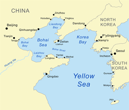
Koreabukten, även kallad Västkoreabukten, är en bukt belägen i norra delen av Gula havet mellan Kina och Nordkorea. Koreabukten är separerad från Bohai av halvön Liaodong vars sydligaste punkt är Dalian.
Media som används på denna webbplats
Shiny red button/marker widget. Used to mark the location of something such as a tourist attraction.
Författare/Upphovsman: Kmusser, Licens: CC BY-SA 2.5
Map of the Bohai Sea and surrounding bays. For a more general map of the same area see Image:Bohai Sea map.png
Författare/Upphovsman: User:Urutseg, Licens: CC0
Stretched version of North Korea physical map.svg in order to be compatible with File:North Korea location map.svg


