Korallhavsöarna
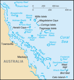
Korallhavsöarna (engelska Coral Sea Islands eller Coral Sea Islands Territory) är en ögrupp i Stilla havet som tillhör Australien.
Historia
Korallhavsöarna utforskades och kartlades 1803 och ansågs då tillhöra Queensland. Territoriet Korallhavsöarna skapades 1969 och förvaltningen överfördes till dåvarande Territories section of the Department of Transport and Regional Services i Canberra, nuvarande Department of Infrastructure, Regional Development and Cities. Territoriet utökades 1997 med Middleton och Elizabeth Reef. 1982 instiftades nationalparken Lihou Reef National Nature Reserve (yta om cirka 8 440 km²) och Coringa-Herald National Nature Reserve (yta om cirka 8 860 km²).
Geografi
Korallhavsöarna ligger i Korallhavet öster om Stora barriärrevet cirka 450 km utanför nordöstra Queenslands kust.
Öarna är en grupp obebodda (förutom Willis Island där några meteorologer bor på en permanent väderstation) låga korallöar och har en area om cirka 3 km² men täcker ett cirka 800 000 km² stort område. Det finns omkring 30 rev- och atollområden, varav 12 ligger under havsytan eller bara syns vid ebb.
Området är uppdelad på tre grupper
- Norra Regionen, som inte tillhör det externa territoriet Korallhavsöarna, med de största reven
- Ashmore Reef (tillhör Queensland)
- Eastern Fields (tillhör Papua Nya Guinea)
- Portlock Reefs (tillhör Papua Nya Guinea)
- samt en rad mindre revområden
- Mellersta Regionen med de flesta reven där de största är
- Abington Reef
- Bougainville Reef
- Coringa Islets, del i "Coringa-Herald National Nature Reserve"
- Dart Reef
- Diane Bank
- Flinders Reefs
- Flora Reef
- Herald Cays, del i "Coringa-Herald National Nature Reserve"
- Heralds Surprise
- Holmes Reef
- Lihou Reefs, den största revområdet i Korallhavsöarna med en yta på cirka 2 500 km²
- Magdelaine Cays, del i "Coringa-Herald National Nature Reserve"
- Malay Reef
- Moore Reef
- Osprey Reef, längst norrut
- Saumarez Reefs, längst söderut
- Tregosse Reefs & Diamond Islets
- Willis Islets
- samt en rad mindre revområden
- Sydöstra Regionen med de största reven
- Cato Reef
- Frederick Reefs
- Kenn Reef
- Mellish Reef
- Wreck Reefs
- samt en rad mindre revområden
- Middleton Reef och Elizabeth Reef tillhör territoriet men ligger längre söderut
Externa länkar
- Karta över territoriet Korallhavsöarna
- Om Korallhavsöarna
- Australiens förvaltning om Korallhavsöarna
- Om nationalparken Lihou reef
- Om nationalparken Coringa-Herald
| |||||||||||
Media som används på denna webbplats
State flag and government ensign (internal waters only) of Victoria.
Flago de la Kokosinsuloj, uzo ne oficiala
State flag and government ensign (internal waters only) of Queensland.
FIAV 110010.svg:
Författare/Upphovsman: user:Dbenbenn, Licens: CC0
The flag of the Australian Capital Territory
It is from openclipart.org, specifically australia_capital_territory.svg by Caleb Moore
Map of the Coral Sea Islands Territory
The flag of the Northern Territory (adopted on July 1, 1978 on the first day of self-government) was designed by the Australian artist Robert Ingpen, of Drysdale Victoria, after consultation with members of the community at the invitation of the Northern Territory Government. The flag incorporates the three official Territorian colours of black, white and ochre and is divided into two panels, black at the hoist side taking up one third the length of the flag while the remainder is equal to two third the length of the flag in ochre. The black panel display the five white stars that form the constellation of the Southern Cross, using the Victorian configuration of the Southern Cross with stars having between five to eight points. The flag also features the official Northern Territory floral emblem on the red ochre panel, a stylisation of the Sturt's Desert Rose, which uses seven petals encircling a seven-pointed black star of the federation in the centre. The seven petals symbolises the six Australian states plus the Northern Territory. The Northern Territory Flag was the first official flag that did not contain the Union Jack.
