Kokosöarna
| Kokosöarna Cocos Islands Keeling Islands | ||||||
|---|---|---|---|---|---|---|
| ||||||
| Valspråk: Maju Pulu Kita | ||||||
| Nationalsång: Advance Australia Fair | ||||||
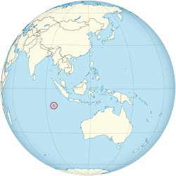
 Kokosöarnas läge | ||||||
| Huvudstad | West Island | |||||
| Största stad | Bantam | |||||
| Officiellt språk | Inget Nationellt språk: Kokosmalajiska, Engelska | |||||
| Statsskick | Australiskt avhängigt territorium | |||||
| - | Regent | Charles III | ||||
| - | Generalguvernör | Peter Cosgrove | ||||
| Självständighet | Australiskt territorium | |||||
| Area | ||||||
| - | Totalt | 14 km² | ||||
| - | Vatten (%) | 0 | ||||
| Befolkning | ||||||
| - | 2014 års uppskattning | 596[1] (236:e) | ||||
| - | Befolkningstäthet | 42,6 inv./km² | ||||
| Valuta | Australisk dollar (AUD) | |||||
| Tidszon | UTC + 6.30 | |||||
| Kör på | Vänster | |||||
| Landskod | CCK, CC | |||||
| Toppdomän | .cc | |||||
| Landsnummer | 61 891 | |||||

Kokosöarna alternativt Cocosöarna, Cocos Islands[2], Keeling Islands, är en australisk ögrupp i Indiska Oceanen. Den är belägen väster om Julön, sydväst om Indonesien. År 2014 beräknades det att det bodde 596 personer på öarna.[1] Huvudorten är West Island och största ort är Bantam Village på Home Island.
Geografi
Kokosöarna består av två låga korallatoller, 14 km² stora. Högsta höjden är fem meter över havet. Klimatet är varmt med sydostliga vindar under nio månader om året. De enda naturresurserna är fisk och kokos och på ön råder det brist på färskvatten. Den norra atollen består av en enda obebodd ö North Keeling Island. Den södra atollen, South Keeling Islands, består av 24 öar varav endast West Island och Home Island är bebodda. De två största obebodda öarna är Horsburgh Island och South Island.
Näringsliv
Det finns en mindre turistindustri som baseras på sol, bad och natur. Det finns en flygplats på West Island med flyg till Australien. En del kokosodling och fiske finns också.
Historia
Ögruppen upptäcktes av kapten William Keeling 1609 men den var obebodd fram till den 6 december 1825 då kapten John Clunies-Ross började röja mark. Han och hans efterföljande blev rika genom att skörda kokos. 1857 blev den en del av Brittiska samväldet. Den 23 november 1955 överfördes ansvaret till Australien. 1978 köpte Australien marken från Clunies-Ross. Den 4 april 1984 röstade invånarna för att ögruppen skulle tillhöra Australien.
Jordbävningen i Indiska oceanen 2004 orsakade inte några dödsfall på Kokosöarna.
Referenser
- ^ [a b] ”The World Factbook — Central Intelligence Agency” (på engelska). www.cia.gov. Arkiverad från originalet den 12 september 2009. https://web.archive.org/web/20090912042550/https://www.cia.gov/library/publications/the-world-factbook/geos/ck.html. Läst 6 oktober 2017.
- ^ Territory of Cocos (Keeling) Islands at GeoNames.Org (cc-by); post uppdaterad 2012-11-27; databasdump nerladdad 2015-12-29
Externa länkar
 Wikimedia Commons har media som rör Kokosöarna.
| |||||||||||
| ||||||||
Media som används på denna webbplats
State flag and government ensign (internal waters only) of Victoria.
Författare/Upphovsman: TUBS
Location of XY (see filename) on the globe.
Flago de la Kokosinsuloj, uzo ne oficiala
State flag and government ensign (internal waters only) of Queensland.
FIAV 110010.svg:
Författare/Upphovsman: user:Dbenbenn, Licens: CC0
The flag of the Australian Capital Territory
It is from openclipart.org, specifically australia_capital_territory.svg by Caleb Moore
Författare/Upphovsman: Spedona, Licens: CC BY-SA 3.0
The coat of arms of the Clunies-Ross family, the former owners of the Cocos (Keeling) Islands. The arms have no official status in the territory.
The flag of the Northern Territory (adopted on July 1, 1978 on the first day of self-government) was designed by the Australian artist Robert Ingpen, of Drysdale Victoria, after consultation with members of the community at the invitation of the Northern Territory Government. The flag incorporates the three official Territorian colours of black, white and ochre and is divided into two panels, black at the hoist side taking up one third the length of the flag while the remainder is equal to two third the length of the flag in ochre. The black panel display the five white stars that form the constellation of the Southern Cross, using the Victorian configuration of the Southern Cross with stars having between five to eight points. The flag also features the official Northern Territory floral emblem on the red ochre panel, a stylisation of the Sturt's Desert Rose, which uses seven petals encircling a seven-pointed black star of the federation in the centre. The seven petals symbolises the six Australian states plus the Northern Territory. The Northern Territory Flag was the first official flag that did not contain the Union Jack.
A map of Cocos (Keeling) Islands.


