Kirtland
| Kirtland | |
| City | |
Kirtland Temple, det första mormontemplet, uppfört 1836. | |
| Officiellt namn: City of Kirtland | |
| Etymologi: Uppkallad efter Turhand Kirtland, veteran från Amerikanska frihetskriget och domare i Trumbull County, den första administrativa enhet i Ohio där Kirtland med omland ingick.[1] | |
| Motto: A City of Faith and Beauty[1] | |
| Land | |
|---|---|
| Delstat | |
| County | Lake County |
| Koordinater | 41°36′9″N 81°20′41″V / 41.60250°N 81.34472°V |
| Högsta punkt | Daniel’s Mountain |
| - höjdläge | 380 m ö.h. |
| Area | 43,52 km² (2019)[2] |
| - land | 43,18 km² (99%)[2] |
| - vatten | 0,34 km² (1%)[2] |
| Folkmängd | 6 812 (2019)[3] |
| Befolkningstäthet | 158 invånare/km² |
| Grundad | 1810-talet |
| - Stadsprivilegier | 1 februari 1971[1] |
| Borgmästare | Kevin F. Potter (ej partival)[4] |
| Tidszon | EST (UTC-5) |
| - sommartid | EDT (UTC-4) |
| Postort | Kirtland |
| Postnummer | 44094 |
| Riktnummer | 440 |
| FIPS-kod | 39-40642 [5] |
| GNIS-kod | 1064951 [6] |
| Geonames | 5159809 |
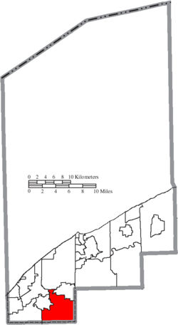
 Kirtlands läge i Lake County. | |
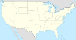
 Ohios läge i USA. | |
| Webbplats: Officiell webbplats. | |
Kirtland är en amerikansk stad i Lake County, Ohio. Befolkningen uppskattades till 6 812 personer (2019).
Staden är främst känd för att Sista dagars heliga-rörelsen hade sitt högkvarter här från 1831 till 1837, i väntan på att kunna bygga en religiös fristad längre västerut. Här byggdes också det första mormontemplet, Kirtland Temple, uppfört 1836. Bland annat ska Joseph Smith fått de uppenbarelser som lett till 46 av de 138 kapitlen i kyrkans heliga skrift, ’’Läran och Förbunden’’, i Kirtland mellan februari 1831 och juli 1837. [7] En av dessa uppenbarelser är det så kallade Visdomsordet, som har en framträdande roll i kyrkans doktrin.
I Kirtland finns även Holden Arboretum, ett av USA:s största arboretum och botaniska trädgårdar, med en yta på mer än 1 500 hektar.
Referenser
- ^ [a b c] ”History of the City of Kirtland”. Kirtland City. https://www.kirtlandohio.com/community-information/organizations/history-of-the-city-of-kirtland/. Läst 4 januari 2021.
- ^ [a b c] ”US Gazetteer Öppen Data för 2019”. United States Census Bureau. https://www2.census.gov/geo/docs/maps-data/data/gazetteer/2019_Gazetteer/2019_gaz_place_39.txt. Läst 4 januari 2021.
- ^ ”US Census Bureau Quickfacts, Kirtland City”. United States Census Bureau. https://www.census.gov/quickfacts/kirtlandcityohio. Läst 4 januari 2021.
- ^ ”Mayor Kevin F. Potter”. Kirtland City. https://www.kirtlandohio.com/departments/mayors-office/mayor-douglas-e-davidson/. Läst 4 januari 2021.
- ^ ”US Census Bureau 2018 års FIPS Codes”. United States Census Bureau. https://www.census.gov/geographies/reference-files/2018/demo/popest/2018-fips.html. Läst 4 januari 2021.
- ^ ”US Board on Geographic Names”. United States Geological Survey. https://www.usgs.gov/core-science-systems/ngp/board-on-geographic-names/download-gnis-data. Läst 4 januari 2021.
- ^ (pdf) Mormons bok - Ännu ett Jesu Kristi testamente; Läran och förbunden i Jesu Kristi kyrka av sista dagars heliga; Den kostbara pärlan. Salt Lake City, USA: Jesu Kristi Kyrka av Sista Dagars Heliga. april 2008 [1830]. ISBN 978-1-59297-627-0. https://www.churchofjesuschrist.org/bc/content/shared/content/swedish/pdf/language-materials/34404_swe.pdf. Läst 4 januari 2021
Media som används på denna webbplats
Shiny red button/marker widget. Used to mark the location of something such as a tourist attraction.
Författare/Upphovsman: Ruhrfisch and Nyttend, Licens: CC BY-SA 3.0
Map of the municipal and township boundaries of Lake County, Ohio, United States, as of the 2000 census, with the location of the city of Kirtland highlighted. Township borders are shown only in unincorporated areas in order to differentiate incorporated and unincorporated areas more clearly.
(c) John Hamer at the English Wikipedia, CC BY-SA 3.0
The Kirtland Temple in Kirtland, Ohio
Författare/Upphovsman: NordNordWest, Licens: CC BY-SA 3.0
Location map of the United States ("lower 48")


