Kern County
| Kern County | ||
| County | ||
| ||
| Land | ||
|---|---|---|
| Delstat | ||
| Huvudort | Bakersfield | |
| Area | 21 141 km² (2010)[1] | |
| - land | 21 062 km² (100%) | |
| - vatten | 79,6 km² (0%) | |
| Folkmängd | 839 631 (2010)[2] | |
| Befolkningstäthet | 40 invånare/km² | |
| Grundat | 1866 | |
| Tidszon | PST (UTC-8) | |
| - sommartid | PDT (UTC-7) | |
| FIPS-kod | 06029 | |
| Geonames | 5362932 | |
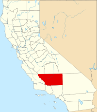
Läge i delstaten Kalifornien. | ||
Delstatens läge i USA. | ||
Kern County är ett administrativt område i delstaten Kalifornien, USA. Den administrativa huvudorten (county seat) är Bakersfield. År 2010 hade Kern County 839 631 invånare.
Geografi
Enligt United States Census Bureau så har countyt en total area på 21 138 km². 21 085 km² av den arean är land och 53 km² är vatten.
Angränsande countyn
- Los Angeles County, Kalifornien - syd
- Ventura County, Kalifornien - syd
- Santa Barbara County, Kalifornien - sydväst
- San Luis Obispo County, Kalifornien - väst
- Monterey County, Kalifornien - nordväst
- Kings County, Kalifornien - nordväst
- Tulare County, Kalifornien - nord
- Inyo County, Kalifornien - nordost
- San Bernardino County, Kalifornien - öst
Källor
- ^ ”2010 Census U.S. Gazetteer Files for Counties”. U.S. Census Bureau. Arkiverad från originalet den 5 juli 2012. https://www.webcitation.org/68vYLbou5?url=http://www.census.gov/geo/www/gazetteer/files/Gaz_counties_national.txt. Läst 5 juli 2012.
- ^ ”State & County QuickFacts, Kern County, Kalifornien” (på engelska). U.S. Census Bureau. Arkiverad från originalet den 13 juli 2011. https://www.webcitation.org/608guDYW3?url=http://quickfacts.census.gov/qfd/states/06/06029.html. Läst 6 juli 2011.
| ||||||||||
|
Media som används på denna webbplats
Författare/Upphovsman: Huebi, Licens: CC BY 2.0
Map of USA with California highlighted
Locator map showing Kern County — in central and southern California.
Flag of California. This version is designed to accurately depict the standard print of the bear as well as adhere to the official flag code regarding the size, position and proportion of the bear, the colors of the flag, and the position and size of the star.
The seal shows the sun and windmills to represent renewable energy. The Tehachapi Mountains and Red Rock Canyon represent tourism. Two planes depict China Lake and Edwards Air Force Base. There's an oil rig and the top five agricultural crops ( Oranges, Almonds, Pistachios, Carrots, and Grapes)


