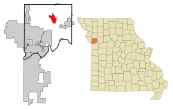
Kearney, Missouri
| Kearney | |
| Stad (city) | |
| Land | |
|---|---|
| Delstat | |
| County | Clay County |
| Höjdläge | 261 m ö.h. |
| Koordinater | 39°21′57″N 94°21′37″V / 39.36583°N 94.36028°V |
| Area | 33,46 km² (2010)[2] |
| Folkmängd | 10 404 (2020)[3] |
| Befolkningstäthet | 311 invånare/km² |
| Grundad | 1856[1] |
| Tidszon | CST (UTC-6) |
| - sommartid | CDT (UTC-5) |
| ZIP-kod | 64060 |
| Riktnummer | 816 |
| GNIS-kod | 730123 |
| Geonames | 4393269 |
Översiktskarta | |
Missouris läge i USA | |
| Webbplats: http://www.ci.kearney.mo.us | |
| Redigera Wikidata | |
Kearney är en ort i Clay County i delstaten Missouri, USA.
Referenser
- ^ hämtat från: franskspråkiga Wikipedia.[källa från Wikidata]
- ^ United States Census Bureau, 2010 U.S. Gazetteer Files, United States Census Bureau, 2010, läst: 9 juli 2020.[källa från Wikidata]
- ^ United States Census Bureau (red.), USA:s folkräkning 2020, läs online, läst: 1 januari 2022.[källa från Wikidata]
Media som används på denna webbplats
Författare/Upphovsman: Americasroof, Licens: CC BY-SA 3.0
Jesse James' farm in Kearney, Missouri
Författare/Upphovsman: Arkyan, Licens: CC BY-SA 3.0
This map shows the incorporated and unincorporated areas in Clay County, Missouri, highlighting Kearney in red. It was created with a custom script with US Census Bureau data and modified with Inkscape.
Författare/Upphovsman: This version: uploader
Base versions this one is derived from: originally created by en:User:Wapcaplet, Licens: CC BY 2.0
Map of USA with Missouri highlighted


