Kastellorizo
| Den här artikeln behöver källhänvisningar för att kunna verifieras. (2023-07) Åtgärda genom att lägga till pålitliga källor (gärna som fotnoter). Uppgifter utan källhänvisning kan ifrågasättas och tas bort utan att det behöver diskuteras på diskussionssidan. |
| Nísos Megísti (Kastelorizo) | |
| Cisthene, Nísos Meyísti, Kastelorrizon, Meis Adası, Castellórizo, Megiste, Megísti, Castelrosso | |
| Ö | |
| Land | |
|---|---|
| Region | Sydegeiska öarna |
| Prefektur | Nomós Dodekanísou |
| Kommun | Dimos Kastellorizo |
| Koordinater | 36°08′32″N 29°34′53″Ö / 36.14222°N 29.58139°Ö |
| Area | 10,04 km² |
| Tidszon | EET (UTC+2) |
| - sommartid | EEST (UTC+3) |
| Geonames | 257079 |
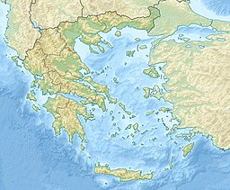
Läge i Grekland | |
Kastellórizo (grekiska: Καστελλόριζο) eller Megísti (grekiska: Μεγίστη) är en mycket liten ö belägen cirka 125 km öst om Rhodos, nästan halvvägs mellan Rhodos och Antalya, 570 km sydöst om Aten, 280 km nordväst om Cypern. Ön hör till den grekiska prefekturen Dodekanisos, och är den östligaste ön både i prefekturen och i Grekland. Ön ligger bara 2,7 kilometer från den turkiska kusten vid Kaş. Antalet invånare är cirka 240. Det finns en liten flygplats, Kastellorizos flygplats, på ön.

Externa länkar
 Wikimedia Commons har media som rör Kastellorizo.
Media som används på denna webbplats
Författare/Upphovsman: Tkgd2007, Licens: CC BY-SA 3.0
A new incarnation of Image:Question_book-3.svg, which was uploaded by user AzaToth. This file is available on the English version of Wikipedia under the filename en:Image:Question book-new.svg
Shiny red button/marker widget. Used to mark the location of something such as a tourist attraction.
Författare/Upphovsman:
- Greece_location_map.svg: Lencer / derivative work: Uwe Dedering (talk)
Location map of Greece
Författare/Upphovsman: Papoutsis Travel, Licens: CC BY-SA 3.0
Kastelorizo Island, Panoramic View, Greece


