Kap York (Grönland)

Kap York
Kap York på kartan över Grönland.
Kap York (grönländska: Innaanganeq) är en udde på nordvästra Grönland, vid den norra delen av Baffinbukten. Udden besöktes i slutet på 1800-talet av Robert Peary som i uddens omgivningar upptäckte tre av Kap York-meteoriterna 1894, bland dem Ahnighito som är världens tredje största hittills funna järnmeteorit. Det finns ett monument i form av en obelisk till minne av Peary på en bergstopp på udden.
Bilder
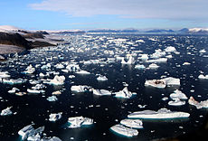 Isberg utanför Kap York
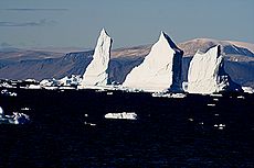 Kap York i september
 Minnesmärket över Peary fotograferat från helikopter (på toppen av det rundade berget i bildens mitt)
 Isberg vid Kap York
 Minnesmärket över Peary
Källor
- Den här artikeln är helt eller delvis baserad på material från Engelskspråkiga Wikipedia, Cape York, 14 juni 2009.
Media som används på denna webbplats

Red pog.svg
Shiny red button/marker widget. Used to mark the location of something such as a tourist attraction.
Shiny red button/marker widget. Used to mark the location of something such as a tourist attraction.

CapeYorkGreenland.jpg
Författare/Upphovsman: Ingen maskinläsbar skapare angavs. Mbz1 antaget (baserat på upphovsrättsanspråk)., Licens: CC BY-SA 3.0
[[w:en:Cape_York,_Greenland|Cape York Greenland]] Photograped by Brocken Inaglory in September of 2005
Författare/Upphovsman: Ingen maskinläsbar skapare angavs. Mbz1 antaget (baserat på upphovsrättsanspråk)., Licens: CC BY-SA 3.0
[[w:en:Cape_York,_Greenland|Cape York Greenland]] Photograped by Brocken Inaglory in September of 2005

Robert Peary monument at Cape York, Greenland.jpg
Författare/Upphovsman: Henrik thomsen, Licens: CC BY-SA 3.0
Robert Peary monument at Cape York Greenland Picture taken April 1993 while repairing VHF Telephone relay station seen in the background
Författare/Upphovsman: Henrik thomsen, Licens: CC BY-SA 3.0
Robert Peary monument at Cape York Greenland Picture taken April 1993 while repairing VHF Telephone relay station seen in the background
Greenland edcp relief location map.jpg
Författare/Upphovsman: Uwe Dedering, Licens: CC BY-SA 3.0
Relief location map of Greenland.
Författare/Upphovsman: Uwe Dedering, Licens: CC BY-SA 3.0
Relief location map of Greenland.
- Projection: EquiDistantConicProjection.
- Area of interest:
- N: 85.0° N
- S: 59.0° N
- W: -75.0° E
- E: -10.0° E
- Projection center:
- NS: 72.0° N
- WE: -42.5° E
- Standard parallels:
- 1: 64.0° N
- 2: 80.0° N
- GMT projection: -JD-42.5/72/64/80/20c
- GMT region: -R-60.16/57.61/24.5/79.91r
- GMT region for grdcut: -R-120.24/57.61/24.5/85.78r
- Relief: SRTM30plus.
- Made with Natural Earth. Free vector and raster map data @ naturalearthdata.com.

Cape York monument.JPG
Författare/Upphovsman: Brocken Inaglory, Licens: CC BY-SA 3.0
Monument to Robert Peary is clearly seen at Cape York, Greenland. The picture was taken from a helicopter.
Författare/Upphovsman: Brocken Inaglory, Licens: CC BY-SA 3.0
Monument to Robert Peary is clearly seen at Cape York, Greenland. The picture was taken from a helicopter.

Iceberg with hole around Cape York, Greenland edit.jpg
Författare/Upphovsman: This image was edited byUser:CillanXC, Licens: CC BY-SA 3.0
Icebergs around Cape York,Greenland. The icebergs are beautiful and display many interesting shapes. You could see the iceberg with a hole at the image. The hole was caused by weathering effects - erosion by waves, wind and melting.

Glaciers and Icebergs at Cape York.jpg
Författare/Upphovsman: Brocken Inaglory, Licens: CC BY-SA 3.0
Icebergs are breaking off glaciers at Cape York, Greenland. The picture was taken from a helicopter.
Författare/Upphovsman: Brocken Inaglory, Licens: CC BY-SA 3.0
Icebergs are breaking off glaciers at Cape York, Greenland. The picture was taken from a helicopter.