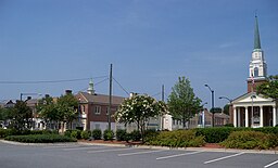
Kannapolis
| Kannapolis | |
| city | |
| Land | |
|---|---|
| Delstat | North Carolina |
| County | Cabarrus County Rowan County |
| Höjdläge | 238 m ö.h. |
| Koordinater | 35°29′14″N 80°37′18″V / 35.48722°N 80.62167°V |
| Yta | 84,3 km² (2010) |
| - land | 82,7 km² |
| - vatten | 1,6 km² |
| Folkmängd | 42 625 (2010) |
| Befolkningstäthet | 515 invånare/km² |
| Tidszon | EST (UTC-5) |
| - sommartid | EDT (UTC-4) |
| ZIP-kod | 28081, 28082, 28083 |
| FIPS | 3735200 |
| Geonames | 4474040 |
Ortens läge i North Carolina | |
North Carolinas läge i USA | |
| Webbplats: http://www.kannapolisnc.gov/ | |
Kannapolis är en stad i North Carolina, USA, nordväst om Concord och nordost om Charlotte. Enligt folkräkningen 2010 bor 42,625 i orten, vilket gör staden till den 20:e största i North Carolina.
Kända personer
- Ralph Earnhardt
- Dale Earnhardt
- Dale Earnhardt Jr.
- George Clinton
- Ethan Horton
- Britt Nicole, sångare
- George Shinn
Vidare läsning
- Minchin, Timothy J., “‘It Knocked This City to Its Knees’: The Closure of Pillowtex Mills in Kannapolis, North Carolina, and the Decline of the U.S. Textile Industry,” Labor History 50 (Aug. 2009), 287–311
Externa länkar
Referenser
Media som används på denna webbplats
Shiny red button/marker widget. Used to mark the location of something such as a tourist attraction.
Författare/Upphovsman: Alexrk2, Licens: CC BY 3.0
Den här Det karta skapades med GeoTools.
Författare/Upphovsman: This version: uploader
Base versions this one is derived from: originally created by en:User:Wapcaplet, Licens: CC BY 2.0
Map of USA with North Carolina highlighted
Författare/Upphovsman: Jon Platek, Licens: CC BY-SA 3.0
Buildings in Kannapolis, North Carolina, USA.


