Jordbävningen i Qayen 1997
| Jordbävningen i Qayen 1997 | |
 | |
| Datum | 10 maj 1997 |
|---|---|
| Drabbade områden | |
| Magnitud | 7,2 Mw |
| Djup | 10 kilometer |
| Skador | |
| Döda | 1 728 |
| Skadade | 5 059 |
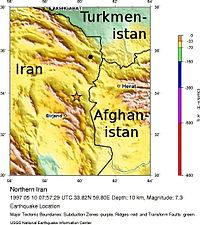
Den 10 maj 1997 drabbades östra Iran av den kraftigaste jordbävningen man haft i området sedan 1990. Den mätte 7,2 på momentmagnitudskalan,[1][2] och hade sitt epicentrum omkring 53 mil söder om Mashhad,[3] vid byn Ardakul i Zirkuh, som vid den tiden var ett distrikt inom delprovinsen Qaenat, även kallad Qaen eller Qayen.
I jordbävningen omkom 1 728 människor, 5 059 skadades och omkring 60 000 blev hemlösa.[3]
Referenser
- ^ M. Berberian et al. The 1997 May 10 Zirkuh (Qa’enat) earthquake (Mw 7.2): faulting along the Sistan suture zone of eastern Iran. Geophysical Journal International, 136(3): 671-694, 1999. Läst 16 mars 2023.
- ^ M. Nemati. Insights into the Aftershocks and Inter-Seismicity for Some Large Persian Earthquakes, Journal of Sciences, Islamic Republic of Iran, 26(1): 35-48, 2015. University of Teheran. Läst 16 mars 2023.
- ^ [a b] Iran: Earthquake, appeal no. 10/97, situation report no. 7 (final). International Federation of Red Cross and Red Crescent Societies (IFRC), 6 januari 1998. Tillgänglig på ReliefWeb. Läst 16 mars 2023.
Media som används på denna webbplats
Flag of Iran. The tricolor flag was introduced in 1906, but after the Islamic Revolution of 1979 the Arabic words 'Allahu akbar' ('God is great'), written in the Kufic script of the Qur'an and repeated 22 times, were added to the red and green strips where they border the white central strip and in the middle is the emblem of Iran (which is a stylized Persian alphabet of the Arabic word Allah ("God")).
The official ISIRI standard (translation at FotW) gives two slightly different methods of construction for the flag: a compass-and-straightedge construction used for File:Flag of Iran (official).svg, and a "simplified" construction sheet with rational numbers used for this file.

