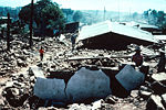
Jordbävningen i Guatemala 1976
| Jordbävningen i Guatemala 1976 | |
| Datum | 4 februari 1976 |
|---|---|
| Tidpunkt | 09:01:43 UTC 03:01:43 lokal tid |
| Drabbade områden | |
| Magnitud | 7,5 |
| Epicentrum | Los Amates |
| Efterskalv | Flera tusen |
| Skador | |
| Döda | 22 870 |
| Skadade | 76 504 |
Jordbävningen i Guatemala 1976 var en jordbävning som inträffade den 4 februari 1976 klockan 03:01:43 lokal tid (09:01:43 UTC-6) med 7,5 Mw. Den var centrerad till Motagua-förkastningen cirka 160 kilometer nordöst om Guatemala City, Guatemala. Hypocentrum låg vid en sänka cirka 5 kilometer vid sidan av staden Los Amates i departementet Izabal.[1].
Städer runtom i Guatemala skadades, och de flesta lerstenhusen runt Guatemala City förstördes helt. Jordbävningen inträffade tidigt på morgonen (runt klockan 03:01 lokal tid) då de flesta fortfarande låg och sov. Detta bidrog till den höga dödssiffran på 22 870 personer. Uppskattningsvis sårades 76 504, och tusentals blev hemlösa. Många områden blev utan elektricitet och kommunikationer i flera dagar.
Huvudskalvet följdes av tusentals efterskalv, där vissa av de större orsakade ytterligare skador och förluster av människoliv.[2]
Seismiska data
Epicentrum låg nära Los Amates, där Nordamerikanska plattan och Karibiska plattan möts.[1] Skakningarna i marken kändes i uppskattningsvis 39 sekunder, och orsakade synliga sprickor på en sträcka av 230 kilometer, under efterskalven uppskattningsvis 300 kilometer. Den genomsnittliga horisontella förskjutningen var 10 centimeter, med ett maximum på 326 centimeter.[1]
Maximal seismisk intensitet (MM IX) rådde i Mixco-området, visa delar av Guatemala City och i Gualán. En seismisk intensitet på MM VI täckte ett område på 33 000 km².[1].
Efterskalv på mellan 5,2 och 5,8 Mw orsakade, förutom extra skador, även försvårande av hjälpinsatser.
| Datum | Originaltid | Koordinater | Plats | Djup | Magnitud |
| 4 februari 1976 | 09.30.28.3 | 14°42′N 90°36′V / 14.7°N 90.6°V | 7 kilometer nord-nordost om Mixco | 5 kilometer | 5,8 Mw |
| 6 februari 1976 | 04.11.03.3 | 14°36′N 91°06′V / 14.6°N 91.1°V | 6 kilometer syd-sydost om San Lucas Tolimán | 5 kilometer | 4,8 Mw |
| 6 februari 1976 | 18.11.59.2 | 14°18′N 90°12′V / 14.3°N 90.2°V | 11 kilometer ost-nordost om Cuilapa | 5 kilometer | 5,2 Mw |
| 6 februari 1976 | 18.19.17.7 | 14°42′N 90°36′V / 14.7°N 90.6°V | 5 kilometer ost-nordost om San Pedro Sacatepéquez | 5 kilometer | 5,8 Mw |
| 8 februari 1976 | 08.13.51.9 | 15°42′N 88°30′V / 15.7°N 88.5°V | 13 kilometer sydöst om Puerto Barrios | 5 kilometer | 5,7 Mw |
| 9 februari 1976 | 11.44.46.7 | 15°18′N 89°06′V / 15.3°N 89.1°V | 30 kilometer väst-sydväst om Morales | 5 kilometer | 5,1 Mw |
| 10 februari 1976 | 06.17.43.0 | 15°00′N 89°42′V / 15.0°N 89.7°V | 18 kilometer väst-nordväst om Zacapa | 5 kilometer | 4,7 Mw |
| 7 mars 1976 | 02.54.05.4 | 14°54′N 90°54′V / 14.9°N 90.9°V | 14.5 kilometer sydväst om Joyabaj | 5 kilometer | 4,8 Mw |
| 7 mars 1976 | 03.15.40.3 | 14°42′N 90°30′V / 14.7°N 90.5°V | Chinautla (9 kilometer nor om Guatemala City) | 5 kilometer | 4,9 Mw |
Offer och skador
Det mest drabbade området täckte ungefär 30 000 kilometer², med en befolkning på 2,5 miljoner. Ungefär 23 000 personer rapporterades ha dödats, och 77 000 skadats. Uppskattningsvis 258 000 hus förstördes, och 1,2 miljoner personer lämnades hemlösa. 40% av sjukhusen förstördes, liksom många andra vårdinrättningar.[3]
I populärkultur
I Take It to the Limit , sista avsnittet av den amerikanska TV-serien Swingtown, Take It to the Limit , informeras Laurie och Doug av en flicka om jordbävningen som om den just inträffat, men ingen hittar något i nyheterna. Avsnittet utspelar sig i september 1976, sju månader efter jordbävningen.
Se även
- Lista över jordbävningar i Guatemala
Bildgalleri
- 1976 Guatemala earthquake
- Krökta järnvägsspår i Gualán
- Hotel Terminal
- Jordskred i Guatemala City
- Motaguaförkastningen i Gualán
- Patzicía helt förstört
- Guatemala Citys centrum
Externa länkar
 Wikimedia Commons har media som rör Jordbävningen i Guatemala 1976.
- USGS Map
- Guatemala Earthquake 1976 - photos by Barbara V.C. DuFlon
Källor
Fotnoter
- ^ [a b c d] NOAA database
- ^ Historic Earthquakes Arkiverad 10 april 2007 hämtat från the Wayback Machine.
- ^ Olcese (e.a.), 1977
- Bates, F.L. (1979). Emergency Food Programmes following the 1976 Guatemalan Earthquake: An Evaluation: Final Report. Washington: USAID. http://pdf.usaid.gov/pdf_docs/PNAAQ014.pdf.
- Bucknam, R.C. (1 mars 1978). ”Fault movement (afterslip) following the Guatemala earthquake of February 4, 1976”. Geology "6" (3): ss. 170–173. doi:. http://geology.gsapubs.org/content/6/3/170.abstract.
- Langer, C.V.. ”Secondary faulting near the terminus of a seismogenic strike-slip fault: aftershocks of the 1976 Guatemala earthquake”. Bulletin of the Seismological Society of America "69" (2): ss. 427–444.
- Matumoto, Tosimatu. ”Aftershocks of the Guatemalan earthquake of February 4, 1976”. Geophysical Research Letters "3" (10): ss. 599–602. doi:.
- Olcese, Orlando (July 1977) (pdf). The Guatemala Earthquake Disaster of 1976: A Review of its Effects and of the contribution of the United Nations family. UNDP, Guatemala. Arkiverad från originalet den 24 juli 2011. https://web.archive.org/web/20110724143304/http://desastres.unanleon.edu.ni/pdf2/2005/septiembre-octubre/parte1/pdf/eng/doc4146/doc4146-1.pdf. Arkiverad 24 juli 2011 hämtat från the Wayback Machine.
- Olson, Robert A. (9 september 1977). ”The Guatemala earthquake of 4 February 1976: Social science observations and research suggestions”. Mass Emergencies (2): ss. 69–81. Arkiverad från originalet den 27 juli 2011. https://web.archive.org/web/20110727070618/http://www.massemergencies.org/v2n2/Olson_v2n2.pdf.
- Plafker, G. (9 september 1976). ”Tectonic aspects of the Guatemala earthquake of 4 February 1976”. Science "193" (4259): ss. 1201–1208. doi:. PMID 17837005.
- Plafker, G.. "Geologic effects in the Guatemala Earthquake of February 4, 1976, a preliminary Report. Professional Paper 1002". USGS.
- USGS (May-June 1976). ”Guatemalan Quake Culprit Fault Identified”. Earthquake Information Bulletin (USGS) "8" (3).
- Young, Christopher J. (1 juni 1989). ”Rupture of the 4 February 1976 Guatemalan earthquake”. Bulletin of the Seismological Society of America "79" (3): ss. 670–689.
- Den här artikeln är helt eller delvis baserad på material från engelskspråkiga Wikipedia.
Media som används på denna webbplats
"Guatemala Earthquake 1976. Typical street view in Patzicia, showing adobe block rubble which is all that remains of the houses that formerly lined this street. The adobe block buildings had very little resistance to horizontal forces and most of them were completely destroyed. Collapse of the heavy adobe walls, roof tiles and beams caused most of the casualties. Many of the adobe blocks are still intact but the mortar between the blocks failed during the seismic shaking. 1976. Slide 43, U.S. Geological Survey Open-File Report 77-165."
- Note: this was from the earthquake of 4 February, 1976.
"Guatemala Earthquake 1976. Collapse of the Hotel Terminal in Guatemala City, caused by the failure of reinforced concrete columns in its third story. 1976. Figure 55, U.S. Geological Survey Professional paper 1002."
- Note: this was from the earthquake of 4 February, 1976.
"Guatemala Earthquake 1976. Foundation failure due to a landslide beneath structures built along the edge of a steep walled valley in Guatemala City. An estimated 5,000 dwellings in this city were made uninhabitable or were threatened by sliding. February 4, 1976."
- Note: this was from the earthquake of 4 February, 1976.
"Guatemala Earthquake 1976. Along Motagua fault trace where it crosses the Gualan soccer field. Note that "mole track" which is best developed in hard packed, brittle surface materials. 1976. Slide 14, U.S. Geological Survey Open-File Report 77-165."
- Note: this was from the earthquake of 4 February, 1976.
"Guatemala Earthquake 1976. Rails bent in Gualan. 1976. Figure 42-A, U.S. Geological Survey Professional paper 1002."
- Note: this was from the earthquake of 4 February, 1976.
"Guatemala Earthquake 1976. Large scale destruction of adobe houses in Guatemala City, Calle 2 and Avenida 9A. 1976. Figure 69-B, U.S. Geological Survey Professional paper 1002."
- Note: this was from the earthquake of 4 February, 1976.


