Jordbävningen i Turkiet och Syrien 2023
| Jordbävningen i Turkiet och Syrien 2023 | |
 | |
| Datum | 6 februari 2023 |
|---|---|
| Drabbade områden | |
| Magnitud | 7,8 |
| Skador | |
| Döda | ≥ 59.259 [1][2][3] |
| Skadade | ≥ 122.007 |
_1.png)


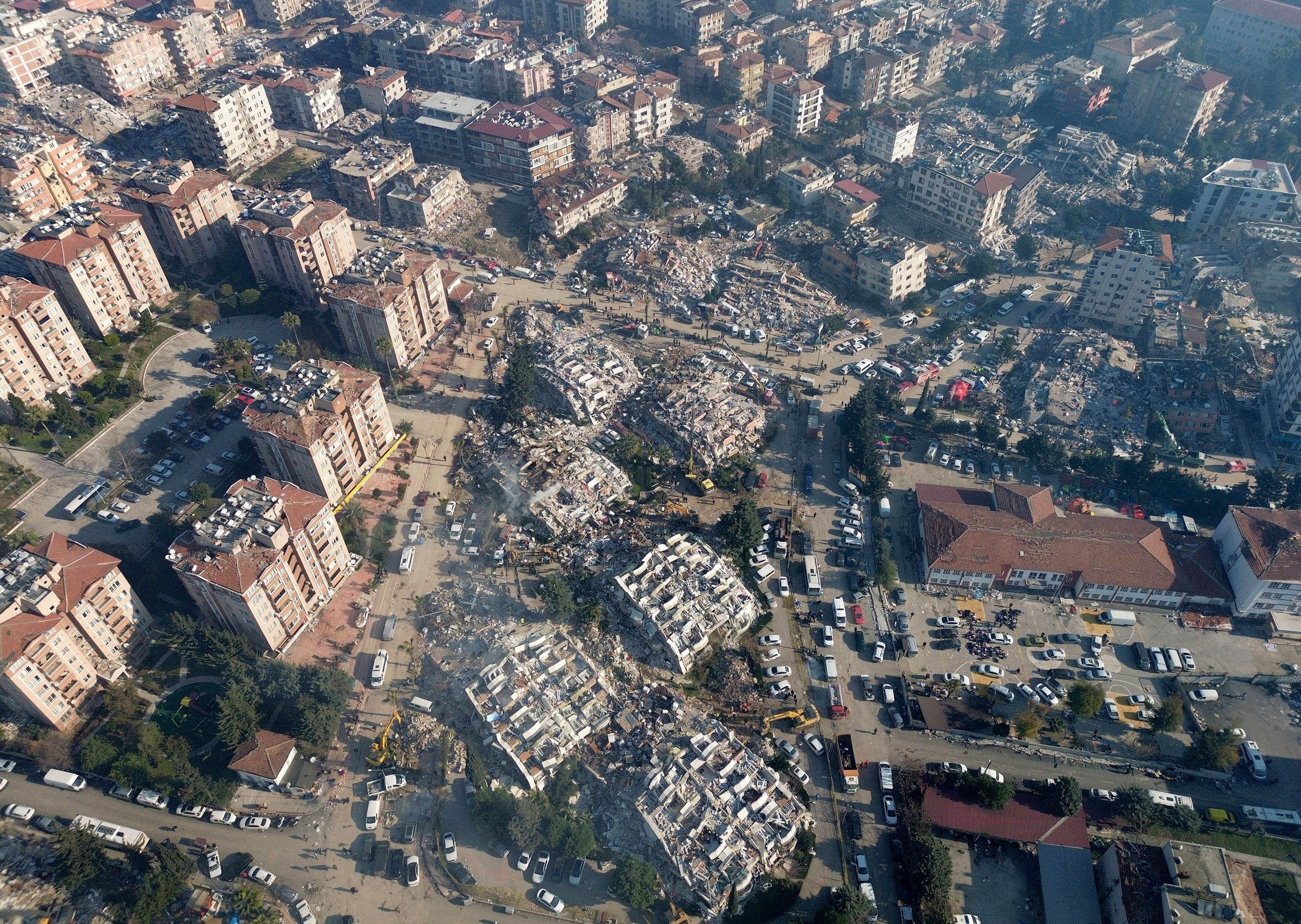
Jordbävningen i Turkiet och Syrien 2023 (turkiska: 2023 Türkiye-Suriye depremleri; arabiska: زلزالا تركيا وسوريا 2023) var en serie jordskalv den 6 februari 2023 som drabbade staden Gaziantep och omgivande områden i södra Turkiet samt delar av norra Syrien.[4]
Jordbävningen uppmättes till 7,8 på momentmagnitudskalan[5] och är den kraftigaste jordbävningen som uppmätts i Turkiet sedan jordbävningen i Erzincan 1939[6] och jordbävningen i İzmit 1999. Den uppges vara den dödligaste jordbävningen i världen sedan jordbävningen i Haiti 2010.
Efterskalv
| Datum | Tid (UTC) | M | Djup (km) | Not |
|---|---|---|---|---|
| 6 februari | 01:17 | 7,8–8,0 | 17,9 | |
| 6 februari | 01:26 | 5,6 | 17,0 | [7] |
| 6 februari | 01:28 | 6,7 | 14,5 | |
| 6 februari | 01:36 | 5,6 | 10,0 | [8] |
| 6 februari | 01:58 | 5,1 | 10,0 | [9] |
| 6 februari | 02:01 | 4,8 | 10,4 | [10] |
| 6 februari | 02:03 | 5,5 | 10,0 | [11] |
| 6 februari | 02:17 | 4,8 | 10,0 | [12] |
| 6 februari | 02:23 | 5,2 | 11,4 | [13] |
| 6 februari | 02:54 | 4,6 | 10,0 | [14] |
| 6 februari | 03:04 | 4,7 | 17,9 | [15] |
| 6 februari | 03:12 | 4,5 | 12,6 | [16] |
| 6 februari | 03:28 | 4,4 | 16,0 | [17] |
| 6 februari | 03:45 | 4,8 | 15,4 | [18] |
| 6 februari | 04:04 | 4,3 | 14,1 | [19] |
| 6 februari | 04:14 | 4,4 | 16,7 | [20] |
| 6 februari | 04:16 | 4,5 | 13,2 | [21] |
| 6 februari | 04:18 | 5,0 | 14,5 | [22] |
| 6 februari | 04:39 | 4,3 | 14,9 | [23] |
| 6 februari | 04:47 | 4,4 | 10,0 | [24] |
| 6 februari | 05:01 | 4,6 | 20,2 | [25] |
| 6 februari | 05:36 | 4,6 | 10,6 | [26] |
| 6 februari | 05:55 | 4,5 | 16,5 | [27] |
| 6 februari | 06:26 | 5,0 | 10,0 | [28] |
| 6 februari | 06:54 | 4,8 | 10,0 | [29] |
| 6 februari | 07:08 | 4,6 | 13,4 | [30] |
| 6 februari | 08:01 | 4,5 | 10,0 | [31] |
| 6 februari | 08:52 | 4,8 | 10,0 | [32] |
| 6 februari | 09:23 | 4,6 | 10,0 | [33] |
| 6 februari | 09:36 | 4,3 | 10,0 | [34] |
| 6 februari | 10:24 | 7,5–7,7 | 10,0 | |
| 6 februari | 10:35 | 5,8 | 10,0 | [35] |
| 6 februari | 10:51 | 5,7 | 10,0 | [36] |
| 6 februari | 11:01 | 5,0 | 10,0 | [37] |
| 6 februari | 11:05 | 5,2 | 10,0 | [38] |
| 6 februari | 11:11 | 4,9 | 18,0 | [39] |
| 6 februari | 12:02 | 6,0 | 10,0 | [40] |
| 6 februari} | 12:13 | 4,8 | 10,0 | [41] |
| 6 februari | 12:34 | 4,9 | 13,0 | [42] |
| 6 februari | 12:36 | 4,7 | 10,0 | [43] |
| 6 februari | 13:00 | 4,5 | 10,0 | [44] |
| 6 februari | 13:07 | 5,0 | 17,1 | [45] |
| 6 februari | 13:17 | 4,5 | 10,0 | [46] |
| 6 februari | 13:39 | 5,1 | 10,0 | [47] |
| 6 februari | 13:44 | 5,0 | 10,0 | [48] |
| 6 februari | 15:14 | 5,3 | 10,0 | [49] |
| 6 februari | 15:33 | 5,2 | 8,8 | [50] |
| 6 februari | 16:26 | 4,8 | 10,0 | [51] |
Källor
Fotnoter
- ^ ”Kraftig jordbävning i Turkiet: Över 3 000 döda”. Expressen. 6 februari 2023. https://www.expressen.se/nyheter/kraftig-jordbavning-i-turkiet/. Läst 6 februari 2023.
- ^ Radlovacki, Natalie; Wikén, Erik (6 februari 2023). ”Turkiet drabbat av kraftiga jordbävningar”. SVT Nyheter. https://www.svt.se/nyheter/utrikes/turkiet-drabbat-av-kraftig-jordbavning. Läst 6 februari 2023.
- ^ ”Live updates: Over 3,000 dead after two massive earthquakes strike Turkey and Syria” (på engelska). NBC News. https://www.nbcnews.com/news/world/live-blog/turkey-syria-earthquake-live-updates-rcna69266. Läst 6 februari 2023.
- ^ ”5000 döda i jordbävningen. Sydsvenska Dagbladet, läst 7 feb 2023.”. https://www.sydsvenskan.se/2023-02-07/over-5-000-doda--sjukhus-overfulla-efter-skalv.
- ^ ”A magnitude 7.8 earthquake struck overnight near Nurdağı, Turkey on February 6 at 01:17 UTC.”. USGS - U.S. Geological Survey. 6 februari 2023. https://www.usgs.gov/news/featured-story/magnitude-78-earthquake-nurdagi-turkey. Läst 7 februari 2023.
- ^ Majlard, Jan (6 februari 2023). ”Expert: 0,2 mer på skalan blir dubbla kraften”. Svenska Dagbladet. ISSN 1101-2412. https://www.svd.se/a/P4j787/jordskalvet-i-turkiet-sa-fungerar-richterskalan. Läst 6 februari 2023.
- ^ ”M 5.6 – 23 km NE of Musabeyli, Turkey”. M 5.6 – 23 km NE of Musabeyli, Turkey. United States Geological Survey. https://earthquake.usgs.gov/earthquakes/eventpage/us6000jlnn/executive.
- ^ ”M 5.6 – 16 km S of Nurdağı, Turkey”. M 5.6 – 16 km S of Nurdağı, Turkey. United States Geological Survey. https://earthquake.usgs.gov/earthquakes/eventpage/us6000jlm9/.
- ^ ”M 5.1 – 6 km ESE of Hasanbeyli, Turkey”. M 5.1 – 6 km ESE of Hasanbeyli, Turkey. United States Geological Survey. https://earthquake.usgs.gov/earthquakes/eventpage/us6000jlmf/.
- ^ ”M 4.8 – 23 km SW of Pazarcık, Turkey”. M 4.8 – 23 km SW of Pazarcık, Turkey. United States Geological Survey. https://earthquake.usgs.gov/earthquakes/eventpage/us6000jlmy/.
- ^ ”M 5.5 – 2 km S of Tut, Turkey”. M 5.5 – 2 km S of Tut, Turkey. United States Geological Survey. https://earthquake.usgs.gov/earthquakes/eventpage/us6000jlmh/.
- ^ ”M 4.8 – 10 km SSW of Nurdağı, Turkey”. M 4.8 – 10 km SSW of Nurdağı, Turkey. United States Geological Survey. https://earthquake.usgs.gov/earthquakes/eventpage/us6000jlmm/.
- ^ ”M 5.2 – 21 km E of Nurdağı, Turkey”. M 5.2 – 21 km E of Nurdağı, Turkey. United States Geological Survey. https://earthquake.usgs.gov/earthquakes/eventpage/us6000jlmn/.
- ^ ”M 4.6 – 15 km E of Denizciler, Turkey”. M 4.6 – 15 km E of Denizciler, Turkey. United States Geological Survey. https://earthquake.usgs.gov/earthquakes/eventpage/us6000jlmv/.
- ^ ”M 4.7 – eastern Turkey”. earthquake.usgs.gov. https://earthquake.usgs.gov/earthquakes/eventpage/us6000jln0/.
- ^ ”M 4.5 – central Turkey”. M 4.5 – central Turkey. United States Geological Survey. https://earthquake.usgs.gov/earthquakes/eventpage/us6000jln3/.
- ^ ”M 4.4 – 6 km NW of Sincik, Turkey”. M 4.4 – 6 km NW of Sincik, Turkey. United States Geological Survey. https://earthquake.usgs.gov/earthquakes/eventpage/us6000jln5/.
- ^ ”M 4.8 – 18 km N of Sincik, Turkey”. M 4.8 – 18 km N of Sincik, Turkey. United States Geological Survey. https://earthquake.usgs.gov/earthquakes/eventpage/us6000jln9/.
- ^ ”M 4.3 – Central Turkey”. M 4.3 – Central Turkey. United States Geological Survey. https://earthquake.usgs.gov/earthquakes/eventpage/us6000jlnc/.
- ^ ”M 4.4 – eastern Turkey”. M 4.4 – eastern Turkey. United States Geological Survey. https://earthquake.usgs.gov/earthquakes/eventpage/us6000jlne/.
- ^ ”M 4.5 – 3 km ENE of Pazarcık, Turkey”. M 4.5 – 3 km ENE of Pazarcık, Turkey. United States Geological Survey. https://earthquake.usgs.gov/earthquakes/eventpage/us6000jlnd/.
- ^ ”M 5.0 – eastern Turkey”. M 5.0 – eastern Turkey. United States Geological Survey. https://earthquake.usgs.gov/earthquakes/eventpage/us6000jlnf/.
- ^ ”M 4.3 – 14 km W of Gölbaşı, Turkey”. M 4.3 – 14 km W of Gölbaşı, Turkey. United States Geological Survey. https://earthquake.usgs.gov/earthquakes/eventpage/us6000jlnq/.
- ^ ”M 4.4 – 8 km SW of Hassa, Turkey”. M 4.4 – 8 km SW of Hassa, Turkey. United States Geological Survey. https://earthquake.usgs.gov/earthquakes/eventpage/us6000jlns/.
- ^ ”M 4.6 – central Turkey”. M 4.6 – central Turkey. United States Geological Survey. https://earthquake.usgs.gov/earthquakes/eventpage/us6000jlnv/.
- ^ ”M 4.6 – 3 km E of Anayazı, Turkey”. M 4.6 – 3 km E of Anayazı, Turkey. United States Geological Survey. https://earthquake.usgs.gov/earthquakes/eventpage/us6000jlp0/.
- ^ ”M 4.5 – 16 km WSW of Sincik, Turkey”. M 4.5 – 16 km WSW of Sincik, Turkey. United States Geological Survey. https://earthquake.usgs.gov/earthquakes/eventpage/us6000jlp1/.
- ^ ”M 5.0 – 12 km NW of İskenderun, Turkey”. M 5.0 – 12 km NW of İskenderun, Turkey. United States Geological Survey. https://earthquake.usgs.gov/earthquakes/eventpage/us6000jlp5/.
- ^ ”M 4.8 – 14 km SE of Çağlayancerit, Turkey”. M 4.8 – 14 km SE of Çağlayancerit, Turkey. United States Geological Survey. https://earthquake.usgs.gov/earthquakes/eventpage/us6000jlp9/.
- ^ ”M 4.6 – 12 km SE of Aşağı Karafakılı, Turkey”. M 4.6 – 12 km SE of Aşağı Karafakılı, Turkey. United States Geological Survey. https://earthquake.usgs.gov/earthquakes/eventpage/us6000jlpb/.
- ^ ”M 4.5 - 14 km SSW of Aşağı Karafakılı, Turkey”. M 4.5 - 14 km SSW of Aşağı Karafakılı, Turkey. United States Geological Survey. https://earthquake.usgs.gov/earthquakes/map/?currentFeatureId=us6000jlpp&extent=33.02709,28.07007&extent=40.80549,45.64819&listOnlyShown=true.
- ^ ”M 4.8 - 7 km SW of Pazarcık, Turkey”. M 4.8 - 7 km SW of Pazarcık, Turkey. United States Geological Survey. https://earthquake.usgs.gov/earthquakes/eventpage/us6000jlpv/.
- ^ ”M 4.6 - Turkey-Syria border region”. M 4.6 - Turkey-Syria border region. United States Geological Survey. https://earthquake.usgs.gov/earthquakes/eventpage/us6000jlq1/.
- ^ ”M 4.3 - Central Turkey”. M 4.3 - Central Turkey. United States Geological Survey. https://earthquake.usgs.gov/earthquakes/map/?currentFeatureId=us6000jlq5&extent=33.02709,28.07007&extent=40.80549,45.64819&listOnlyShown=true.
- ^ ”M 5.8 - 13 km SW of Doğanşehir, Turkey”. M 5.8 - 13 km SW of Doğanşehir, Turkey. United States Geological Survey. https://earthquake.usgs.gov/earthquakes/map/?currentFeatureId=us6000jlqe&extent=33.02709,28.07007&extent=40.80549,45.64819&listOnlyShown=true.
- ^ ”M 5.7 - eastern Turkey”. M 5.7 - eastern Turkey. United States Geological Survey. https://earthquake.usgs.gov/earthquakes/map/?currentFeatureId=us6000jlql&extent=33.02709,28.07007&extent=40.80549,45.64819&listOnlyShown=true.
- ^ ”M 5.0 - 6 km W of Pazarcık, Turkey”. M 5.0 - 6 km W of Pazarcık, Turkey. United States Geological Survey. https://earthquake.usgs.gov/earthquakes/eventpage/us6000jlqy/.
- ^ ”M 5.2 - 20 km ESE of Göksun, Turkey”. M 5.2 - 20 km ESE of Göksun, Turkey. United States Geological Survey. https://earthquake.usgs.gov/earthquakes/map/?currentFeatureId=us6000jlqr&extent=33.02709,28.07007&extent=40.80549,45.64819&listOnlyShown=true.
- ^ ”M 4.9 - 8 km N of Çağlayancerit, Turkey”. M 4.9 - 8 km N of Çağlayancerit, Turkey. United States Geological Survey. https://earthquake.usgs.gov/earthquakes/eventpage/us6000jlqx/.
- ^ ”M 6.0 - 5 km NE of Göksun, Turkey”. M 6.0 - 5 km NE of Göksun, Turkey. United States Geological Survey. https://earthquake.usgs.gov/earthquakes/eventpage/us6000jlqa/.
- ^ ”M 4.8 - 7 km SSW of Nurhak, Turkey”. M 4.8 - 7 km SSW of Nurhak, Turkey. United States Geological Survey. https://earthquake.usgs.gov/earthquakes/eventpage/us6000jlrg/.
- ^ ”M 4.9 - 9 km N of Çelikhan, Turkey”. M 4.9 - 9 km N of Çelikhan, Turkey. United States Geological Survey. https://earthquake.usgs.gov/earthquakes/eventpage/us6000jlrj/.
- ^ ”M 4.7 - 8 km N of Çelikhan, Turkey”. M 4.7 - 8 km N of Çelikhan, Turkey. United States Geological Survey. https://earthquake.usgs.gov/earthquakes/eventpage/us6000jlrk/.
- ^ ”M 4.5 - 13 km WSW of Darende, Turkey”. M 4.5 - 13 km WSW of Darende, Turkey. United States Geological Survey. https://earthquake.usgs.gov/earthquakes/eventpage/us6000jlrt/.
- ^ ”M 5.0 - 3 km NNW of Nurhak, Turkey”. M 5.0 - 3 km NNW of Nurhak, Turkey. United States Geological Survey. https://earthquake.usgs.gov/earthquakes/eventpage/us6000jlrv/.
- ^ ”M 4.9 - 20 km SW of Göksun, Turkey”. M 4.9 - 20 km SW of Göksun, Turkey. United States Geological Survey. https://earthquake.usgs.gov/earthquakes/eventpage/us6000jls0/.
- ^ ”M 5.1 - 3 km ENE of Kahramanmaraş, Turkey”. M 5.1 - 3 km ENE of Kahramanmaraş, Turkey. United States Geological Survey. https://earthquake.usgs.gov/earthquakes/eventpage/us6000jls3/.
- ^ ”M 5.0 - 7 km SE of Nurhak, Turkey”. M 5.0 - 7 km SE of Nurhak, Turkey. United States Geological Survey. https://earthquake.usgs.gov/earthquakes/eventpage/us6000jls6/.
- ^ ”M 5.3 - 12 km NE of Gölbaşı, Turkey”. M 5.3 - 12 km NE of Gölbaşı, Turkey. United States Geological Survey. https://earthquake.usgs.gov/earthquakes/eventpage/us6000jlsq/.
- ^ ”M 5.2 - 15 km NNW of Çelikhan, Turkey”. M 5.2 - 15 km NNW of Çelikhan, Turkey. United States Geological Survey. https://earthquake.usgs.gov/earthquakes/eventpage/us6000jlsu/.
- ^ ”M 4.8 - 10 km E of Göksun, Turkey”. M 4.8 - 10 km E of Göksun, Turkey. United States Geological Survey. https://earthquake.usgs.gov/earthquakes/eventpage/us6000jlt1.
Externa länkar
Media som används på denna webbplats

Författare/Upphovsman: James St. John, Licens: CC BY 2.0
This seismogram is from the Ankara seismic station in Turkey. The noise is from a magnitude 7.8 earthquake that hit southern Turkey at 3:17 AM, local time, on 6 February 2023. The epicenter was just east of the town of Atalar and northwest of Bayatli in southern Turkey. The hypocenter was between 15 and 20 kilometers deep. Shaking resulted from strike-slip movement along a northeast-southwest trending fault zone or a northwest-southeast trending fault zone. This is the fourth magnitude 7+ earthquake of 2023. The quake occurred during a Moon-Earth-Sun alignment.
Info. at: earthquake.usgs.gov/earthquakes/eventpage/us6000jllz/exec... [An event-specific summary is at the bottom of that page.]
An earthquake is a natural shaking or vibrating of the Earth caused by sudden fault movement and a rapid release of energy. Earthquake activity is called "seismicity". The study of earthquakes is called "seismology". The actual underground location of an earthquake is the hypocenter, or focus. The site at the Earth's surface, directly above the hypocenter, is the epicenter. Minor earthquakes may occur before a major event - such small quakes are called foreshocks. Minor to major quakes after a major event are aftershocks.
Most earthquakes occur at or near tectonic plate boundaries, such as subduction zones, mid-ocean ridges, collision zones, and transform plate boundaries. They also occur at hotspots - large subsurface mantle plumes (Examples: Hawaii, Yellowstone, Iceland, Afar).
Earthquakes generate four types of shock waves: P-waves, S-waves, Love waves, and Rayleigh waves. P-waves and S-waves are body waves - they travel through solid rocks. Love waves and Rayleigh waves travel only at the surface - they are surface waves. P-waves are push-pull waves that travel quickly and cause little damage. S-waves are up-and-down waves (like flicking a rope) that travel slowly and cause significant damage. Love waves are side-to-side surface waves, like a slithering snake. Rayleigh waves are rotational surface waves, somewhat like ripples from tossing a pebble into a pond.
Earthquakes are associated with many specific hazards, such as ground shaking, ground rupturing, subsidence (sinking), uplift (rising), tsunamis, landslides, fires, and liquefaction.
Some famous major earthquakes in history include: Shensi, China in 1556; Lisbon, Portugal in 1755; New Madrid, Missouri in 1811-1812; San Francisco, California in 1906; Anchorage, Alaska in 1964; and Loma Prieta, California in 1989.The wreckage of a collapsed building, Diyarbakır, Turkey.
Författare/Upphovsman: Adem, Licens: CC BY-SA 4.0
2023 Turkey–Syria earthquake
Författare/Upphovsman: Kurmanbek, Licens: CC BY-SA 4.0
Aid collected in Eyüpsultan, Istanbul for the 2023 Gaziantep-Kahramanmaraş earthquakes
%2c_Flag_of_Syria_(1980%e2%80%932024).svg)
Det är enkelt att lägga till en ram runt den här bilden