Jicarilla, New Mexico
| Jicarilla, New Mexico | |
| Ort | |
Skolhuset i Jicarilla. | |
| Land | |
|---|---|
| Delstat | |
| Koordinater | 33°52′8″N 105°39′47″V / 33.86889°N 105.66306°V |
| Tidszon | MST (UTC-7) |
| - sommartid | MDT (UTC-6) |
| GNIS-kod | 907360 |
Ortens läge i delstaten | |
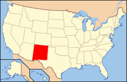
New Mexicos läge i USA | |
| Redigera Wikidata | |
Jicarilla är sedan 1942 en spökstad[1] i Lincoln County som ligger i delstaten New Mexico i USA.[2]
Historia
Redan 1850 började de första guldsökarna komma till Jicarilla Mountains, men det skulle ta tid innan de första gruvorna etablerades.
År 1892 började staden att byggas då en större guldfyndighet hittades i Jicarilla Mountains.
Staden uppkallades efter indianerna som bodde i berg, Jicarillaapacher.[3]
1892 fick staden postkontor.[4]
Under den ekonomiska lågkonjunkturen på 1930-talet stängdes gruvorna. Folk flyttade från staden, då arbetstillfällena försvann.
Källor
- ^ ”Jicarilla - New Mexico Ghost Town”. www.ghosttowns.com. http://www.ghosttowns.com/states/nm/jicarilla.html.
- ^ US Geological Survey Geographic Names Information System: Jicarilla, New Mexico
- ^ Harris, Linda G. (2003). Ghost Towns Alive: Trips to New Mexico's Past. UNM Press. sid. 134. ISBN 978-0-8263-2908-0. http://books.google.com/books?id=SRwANLebiBcC&pg=PA134
- ^ US Geological Survey Geographic Names Information System: Jicarilla Post Office (historical)
| ||||||||||||||
Media som används på denna webbplats
Författare/Upphovsman: Alexrk2, Licens: CC BY 3.0
Den här Det karta skapades med GeoTools.
Shiny red button/marker widget. Used to mark the location of something such as a tourist attraction.
Författare/Upphovsman: This version: uploader
Base versions this one is derived from: originally created by en:User:Wapcaplet, Licens: CC BY 2.0
Map of USA with New Mexico highlighted
Författare/Upphovsman: Elyn Clarke, Licens: CC BY-SA 3.0
Jicarilla Schoolhouse


