Jervis Bay Territory
| Jervis Bay Territory | |
| Territorium | |
Gränsen mot Jervis Bay Territory | |
| Land | |
|---|---|
| Area | 67,8 km² |
| Folkmängd | 391 (2016)[1] |
| Befolkningstäthet | 6 invånare/km² |
| Grundad | 12 maj 1989 |
| Tidszon | AEST (UTC+10) |
| - sommartid | AEDT (UTC+11) |
| Postnummer | 2540 |
| Geonames | 8335033 |
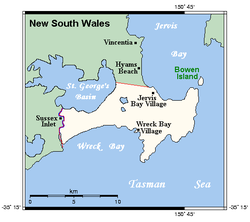
Jervis Bay Territory, territorium i Australien. Fram till 11 maj 1989[2] var det en del av Australian Capital Territory, och det använder fortfarande i huvudsak dess lagar, och räknas in i underlaget för dess representation i representanthuset. Området inköptes 1915 av det Australiska samväldet från New South Wales för att ge huvudstaden en hamn.
Territoriet hade 391 invånare vid folkräkningen 2016[1], de flesta anställda vid flottbasen HMAS Creswell.
I territoriet finns nationalparken Booderee National Park.
Källor
Fotnoter
- ^ [a b] ”Jervis Bay” (på engelska). 2016 Census QuickStats. Australian Bureau of Statistics. Arkiverad från originalet den 7 november 2017. https://web.archive.org/web/20171107015920/http://www.censusdata.abs.gov.au/census_services/getproduct/census/2016/quickstat/SSC90003?opendocument. Läst 6 november 2017.
- ^ ”States of Australia” (på engelska). World Statesmen. http://www.worldstatesmen.org/Australian_States.html#Jervis. Läst 29 december 2012.
Externa länkar
 Wikimedia Commons har media som rör Jervis Bay Territory.
| |||||||||||
|
Media som används på denna webbplats
Författare/Upphovsman: NordNordWest, Licens: CC BY-SA 3.0
Location map of Australia
Shiny red button/marker widget. Used to mark the location of something such as a tourist attraction.
State flag and government ensign (internal waters only) of Queensland.
FIAV 110010.svg:
State flag and government ensign (internal waters only) of Victoria.
Flago de la Kokosinsuloj, uzo ne oficiala
Författare/Upphovsman: Rufusferret, Licens: CC BY-SA 3.0
Border at Jervis Bay Territory and NSW
Författare/Upphovsman: Kelisi, Licens: CC BY-SA 3.0
Carte de la baie de Jervis
Författare/Upphovsman: user:Dbenbenn, Licens: CC0
The flag of the Australian Capital Territory
It is from openclipart.org, specifically australia_capital_territory.svg by Caleb Moore
The flag of the Northern Territory (adopted on July 1, 1978 on the first day of self-government) was designed by the Australian artist Robert Ingpen, of Drysdale Victoria, after consultation with members of the community at the invitation of the Northern Territory Government. The flag incorporates the three official Territorian colours of black, white and ochre and is divided into two panels, black at the hoist side taking up one third the length of the flag while the remainder is equal to two third the length of the flag in ochre. The black panel display the five white stars that form the constellation of the Southern Cross, using the Victorian configuration of the Southern Cross with stars having between five to eight points. The flag also features the official Northern Territory floral emblem on the red ochre panel, a stylisation of the Sturt's Desert Rose, which uses seven petals encircling a seven-pointed black star of the federation in the centre. The seven petals symbolises the six Australian states plus the Northern Territory. The Northern Territory Flag was the first official flag that did not contain the Union Jack.


