Interstate 95
| Interstate 95 | |
| Interstate 95 | |
 | |
 | |
| Längd | 3 101 km |
|---|---|
| Byggd | 1957 |
| Södra änden | |
| Huvudavfarter | |
| Norra änden | |
Interstate 95 eller I-95 är en del av Interstate Highway System och är en av USA:s viktigaste vägar. Den går längs den folkrika östkusten och passerar städer som Miami, Washington, D.C., Baltimore, Philadelphia, New York och Boston.
I-95 är en av de mest trafikerade vägarna i USA och är ett välkänt begrepp bland befolkningen.[1]
Delstater och orter som vägen passerar (från norr till söder)
- Maine (487,95 km)
- New Hampshire (25,93 km)
- Massachusetts (147,98 km)
- Rhode Island (68,17 km)
- Connecticut (179,55 km)
- New York (37,82 km)
- New Jersey (143,22 km)
- Pennsylvania (71,21 km)
- Delaware (37,71 km)
- Maryland (177,04 km)
- District of Columbia (0,18 km)
- Virginia (287,64 km)
- North Carolina (291,87 km)
- South Carolina (319.87 km)
- Georgia (180,25 km)
- Florida (615,01 km)
Galleri
 (c) Wallace Parry, CC BY-SA 3.0Vägens slutpunkt i norr vid gränsen till Kanada.
 På George Washington Bridge går I-95 över Hudsonfloden och gränsen mellan delstaterna New York och New Jersey. Vy från New Jersey-sidan.
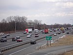 Interstate 95 sydväst om Philadelphia.
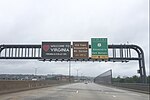
 Interstate 95 i nordlig riktning med avfart till Interstate 16 vid Savannah, Georgia.
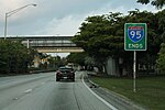 Vägens slutpunkt i söder i Miami.
Se även
Referenser
- Den här artikeln är helt eller delvis baserad på material från engelskspråkiga Wikipedia, Interstate 95, 2 september 2021.
Noter
- ^ Posner, Stan; Sandra Philips (2010). Drive I-95: Exit by Exit Info, Maps, History and Trivia 5th Edition. Travelsmart. ISBN 1894979397
Externa länkar
- I-95 Live Traffic
 Wikimedia Commons har media som rör Interstate 95.
| |||||||
Media som används på denna webbplats

I-80.svg
600 mm by 600 mm (24 in by 24 in) Interstate shield, made to the specifications of the 2004 edition of Standard Highway Signs (sign M1-1). Uses the Roadgeek 2005 fonts. (United States law does not permit the copyrighting of typeface designs, and the fonts are meant to be copies of a U.S. Government-produced work anyway.) Colors are from [1] (Pantone Red 187 and Blue 294), converted to RGB by [2]. The outside border has a width of 1 (1 mm) and a color of black so it shows up; in reality, signs have no outside border.
600 mm by 600 mm (24 in by 24 in) Interstate shield, made to the specifications of the 2004 edition of Standard Highway Signs (sign M1-1). Uses the Roadgeek 2005 fonts. (United States law does not permit the copyrighting of typeface designs, and the fonts are meant to be copies of a U.S. Government-produced work anyway.) Colors are from [1] (Pantone Red 187 and Blue 294), converted to RGB by [2]. The outside border has a width of 1 (1 mm) and a color of black so it shows up; in reality, signs have no outside border.

I-blank.svg
Uses the Roadgeek 2005 fonts. (United States law does not permit the copyrighting of typeface designs, and the fonts are meant to be copies of a U.S. Government-produced work anyway.) Colors are from [1] (Pantone Red 187 and Blue 294), converted to RGB by [2]. The outside border has a width of 1 (1 mm) and a color of black so it shows up; in reality, signs have no outside border.
Uses the Roadgeek 2005 fonts. (United States law does not permit the copyrighting of typeface designs, and the fonts are meant to be copies of a U.S. Government-produced work anyway.) Colors are from [1] (Pantone Red 187 and Blue 294), converted to RGB by [2]. The outside border has a width of 1 (1 mm) and a color of black so it shows up; in reality, signs have no outside border.
.jpg)
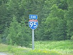
I-95 Ends (33999702361).jpg
Författare/Upphovsman: formulanone from Huntsville, United States, Licens: CC BY-SA 2.0
South end of Interstate 95 in Miami, at US Route 1. These signs went up in the mid-2000s.
Författare/Upphovsman: formulanone from Huntsville, United States, Licens: CC BY-SA 2.0
South end of Interstate 95 in Miami, at US Route 1. These signs went up in the mid-2000s.


95-junction-16.JPG
Författare/Upphovsman: User:MPD01605, Licens: CC BY-SA 3.0
Interstate Highway Signs
Författare/Upphovsman: User:MPD01605, Licens: CC BY-SA 3.0
Interstate Highway Signs


US 1.svg
600 mm × 600 mm (24 in × 24 in) U.S. Highway shield, made to the specifications of the 2004 edition of Standard Highway Signs. (Note that there is a missing "J" label on the left side of the diagram.) Uses the Roadgeek 2005 fonts. (United States law does not permit the copyrighting of typeface designs, and the fonts are meant to be copies of a U.S. Government-produced work anyway.)
600 mm × 600 mm (24 in × 24 in) U.S. Highway shield, made to the specifications of the 2004 edition of Standard Highway Signs. (Note that there is a missing "J" label on the left side of the diagram.) Uses the Roadgeek 2005 fonts. (United States law does not permit the copyrighting of typeface designs, and the fonts are meant to be copies of a U.S. Government-produced work anyway.)
_towards_the_eastbound_George_Washington_Bridge_from_the_overpass_for_NJ_Route_445_(Palisades_Parkway)_in_Fort_Lee%2c_Bergen_County%2c_New_Jersey_2.jpg)
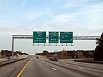
2021-06-06 10 31 05 View north along I-95, US 1 and US 9 and east along US 46 (Bergen-Passaic Expressway) towards the eastbound George Washington Bridge from the overpass for NJ Route 445 (Palisades Parkway) in Fort Lee, Bergen County, New Jersey 2.jpg
Författare/Upphovsman: Famartin, Licens: CC BY-SA 4.0
View north along Interstate 95, U.S. Route 1 and U.S. Route 9 and east along U.S. Route 46 (Bergen-Passaic Expressway) towards the eastbound George Washington Bridge from the overpass for New Jersey State Route 445 (Palisades Interstate Parkway) in Fort Lee, Bergen County, New Jersey
_as_it_crosses_the_Potomac_River_on_the_Woodrow_Wilson_Bridge_in_Alexandria%2c_Virginia.jpg)
2016-07-04 15 36 52 Welcome to Virginia sign along southbound Interstate 95 and the westbound inner loop of the Capital Beltway (Interstate 495) as it crosses the Potomac River on the Woodrow Wilson Bridge in Alexandria, Virginia.jpg
Författare/Upphovsman: Famartin, Licens: CC BY-SA 4.0
Welcome to Virginia sign 1 mile before Exit 177 (U.S. Route 1, Alexandria, Fort Belvoir) along southbound Interstate 95 and the westbound inner loop of the Capital Beltway (Interstate 495) as it crosses the Potomac River on the Woodrow Wilson Bridge in Alexandria, Virginia


NB 95.png
Shield of the New Brunswick Highway 95.
Shield of the New Brunswick Highway 95.
_Exit_9B.JPG)
I-95 (PA) Exit 9B.JPG
Författare/Upphovsman: User:Krimpet, Licens: CC BY-SA 3.0
I-95 south of Philadelphia, from the Exit 9 cloverleaf
Författare/Upphovsman: User:Krimpet, Licens: CC BY-SA 3.0
I-95 south of Philadelphia, from the Exit 9 cloverleaf